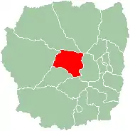
Miarinarivo | |
|---|---|
 Miarinarivo | |
 Miarinarivo Location in Madagascar | |
| Coordinates: 18°57′39″S 46°54′00″E / 18.96083°S 46.90000°E | |
| Country | |
| Region | Itasy |
| District | Miarinarivo |
| Area | |
| • Land | 17.9 km2 (6.9 sq mi) |
| Population (2018)census | |
| • Total | 13,109 |
| • Ethnicities | Merina |
| Time zone | UTC3 (EAT) |
| Postal code | 117 |
Miarinarivo is a city (commune urbaine) in Itasy Region, in the Central Highlands of Madagascar.
Miarinarivo is located at 100 km (62 mi) of Antananarivo and is the capital of Itasy Region as well as of its district. It is crossed by the National Road 1 that leads from Antananarivo to Tsiroanomandidy.[1]
Education
In Miarinarivo are situated:[2]
- 6 primary schools with 2000 pupils
- 4 secondary schools with 1400 pupils
- 4 Lycée with 900 students
Sports
Football/Soccer
The local club CNaPS Sport is the best football club in the city. The club has been 7 times Malagasy champions, 3 times Malagasy cup champions and Malagasy super-cup champions once.
Religion
- FJKM - Fiangonan'i Jesoa Kristy eto Madagasikara (Church of Jesus Christ in Madagascar)
- FLM - Fiangonana Loterana Malagasy (Malagasy Lutheran Church)
- Roman Catholic Church (Katedraly Kristy Mpanjaka (Cathedral of Christ the King)).[3]
References
- ↑ Roads in Itasy
- ↑ ny-hary.de
- ↑ (in French)Portail de l'eglise catholique à Madagascar Archived 2013-04-20 at the Wayback Machine
This article is issued from Wikipedia. The text is licensed under Creative Commons - Attribution - Sharealike. Additional terms may apply for the media files.
