Meclov | |
|---|---|
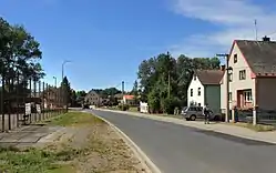 Main road in Meclov | |
 Flag  Coat of arms | |
 Meclov Location in the Czech Republic | |
| Coordinates: 49°30′29″N 12°52′40″E / 49.50806°N 12.87778°E | |
| Country | |
| Region | Plzeň |
| District | Domažlice |
| First mentioned | 1115 |
| Area | |
| • Total | 31.98 km2 (12.35 sq mi) |
| Elevation | 396 m (1,299 ft) |
| Population (2023-01-01)[1] | |
| • Total | 1,208 |
| • Density | 38/km2 (98/sq mi) |
| Time zone | UTC+1 (CET) |
| • Summer (DST) | UTC+2 (CEST) |
| Postal codes | 345 21, 346 01 |
| Website | www |
Meclov (German: Metzling) is a municipality and village in Domažlice District in the Plzeň Region of the Czech Republic. It has about 1,200 inhabitants.
Meclov lies approximately 9 kilometres (6 mi) north-west of Domažlice, 45 km (28 mi) south-west of Plzeň, and 129 km (80 mi) south-west of Prague.
Administrative parts
Villages of Bozdíš, Březí, Jeníkovice, Mašovice, Mračnice, Mrchojedy, Němčice and Třebnice are administrative parts of Meclov.
References
Wikimedia Commons has media related to Meclov.
This article is issued from Wikipedia. The text is licensed under Creative Commons - Attribution - Sharealike. Additional terms may apply for the media files.