Mayadin District
منطقة الميادين | |
|---|---|
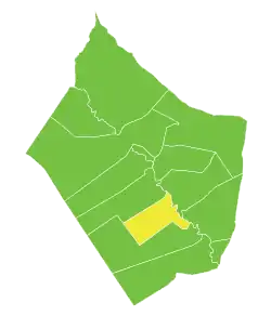
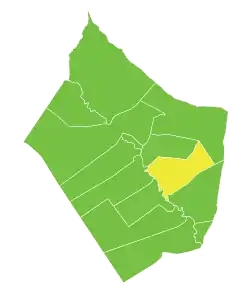
 Map of Mayadin District within Deir ez-Zor Governorate shown in Yellow color | |
| Coordinates (Mayadin): 35°01′N 40°27′E / 35.017°N 40.450°E | |
| Country | |
| Governorate | Deir ez-Zor |
| Seat | Mayadin |
| Subdistricts | 3 nawāḥī |
| Area | |
| • Total | 3,954.98 km2 (1,527.03 sq mi) |
| Population (2004)[1] | |
| • Total | 247,171 |
| • Density | 62/km2 (160/sq mi) |
| Geocode | SY0902 |
Mayadin District (Arabic: منطقة الميادين) is a district (mantiqah) administratively belonging to Deir ez-Zor Governorate, Syria. At the 2004 official census, the district had a population of 247,171.[2] Its administrative centre is the city of Mayadin.
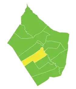
The administrative center of Mayadin Subdistrict shown above is the city of Mayadin.
The administrative center of Al-Asharah Subdistrict shown above is the city of Al-Asharah.
The administrative center of Diban Subdistrict shown above is the city of Diban.
Subdistricts
The district of Mayadin is divided into three subdistricts or Nāḥiyas (population according to 2004 official census):
- Mayadin Subdistrict (ناحية الميادين): population 86,091.[3]
- Diban Subdistrict (ناحية ذيبان): population 65,079.[4]
- Al-Asharah Subdistrict (ناحية عشارة): population 96,001.[5]
References
- ↑ "2004 Census Data". UN OCHA. Retrieved 15 October 2015.
- ↑ 2004 official census Archived 2013-03-10 at the Wayback Machine
- ↑ "Mayadin nahiyah population". Cbssyr.org. Archived from the original on September 25, 2020. Retrieved 2012-06-18.
- ↑ "Dhiban nahiyah population". Cbssyr.org. Archived from the original on September 25, 2020. Retrieved 2012-06-18.
- ↑ "Esharah nahiyah population". Cbssyr.org. Archived from the original on 2020-01-10. Retrieved 2012-06-18.
This article is issued from Wikipedia. The text is licensed under Creative Commons - Attribution - Sharealike. Additional terms may apply for the media files.