Masasi Town Council
| |
|---|---|
| Wilaya na Halmashauri ya Masasi Mjini, Mkoa wa Mtwara | |
| Nickname: "Cashew town" | |
 Masasi Town District of Mtwara Region | |
| Coordinates: 10°44′5.64″S 38°48′15.84″E / 10.7349000°S 38.8044000°E | |
| Country | |
| Region | Mtwara Region |
| District | Masasi Town Council District |
| Area | |
| • District | 753.3 km2 (290.9 sq mi) |
| Elevation | 433 m (1,421 ft) |
| Population (2022 census)[1] | |
| • District | 136,585 |
| • Density | 180/km2 (470/sq mi) |
| • Urban | 89,700 |
| Demonym | Masasi Towner |
| Tanzanian Postal Code | 635** |
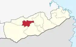
Masasi Town District Council is one of eight regional councils of the Mtwara Region in Tanzania. It is bordered to the north and south by the Masasi District, to the east by the Newala District and to the west by the Nanyumbu District. According to the 2012 census, the district has a total population of 102,969.[2]
Geography
The district covers an area of 753.3 km2 (290.9 sq mi),[3] and has an average elevation of 433 m (1,421 ft).[4]
Administrative subdivisions
Wards
The Masasi Town Council administratively has 14 wards.[5]
References
- ↑ Citypopulation.de Population of Masasi Town
- ↑ "2012 Population and Housing Census General Report" (PDF). Government of Tanzania. Retrieved 2022-02-24.
- ↑ "Tanzania: Coastal Tanzania (Districts and Wards) – Population Statistics, Charts and Map".
- ↑ "Masasi Town Council District Elevation".
- ↑ "Masasi Town Council Divisions".
This article is issued from Wikipedia. The text is licensed under Creative Commons - Attribution - Sharealike. Additional terms may apply for the media files.