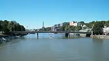
Martinsilta (St. Martin's Bridge) (Swedish: Martinsbron) is a beam bridge spanning the Aurajoki river in Turku, Finland. It was built in 1940, although a proposed bridge appeared on its present location already in the city plan that Carl Ludvig Engel created after the Great Fire of Turku of 1827.[1] The bridge is 104.5 metres (343 ft) in length.
The bridge is a one-way bridge crossing from Linnankatu to Itäinen Rantakatu in a south-southeast direction. The nearby Myllysilta bridge carries one-way traffic in the opposite direction. In 2010, due to the collapse of the Myllysilta bridge, Martinsilta was temporarily turned into a two-way bridge until Myllysilta was rebuilt and opened to traffic.[2]
References
- ↑ Iso tietosanakirja, 14.ofsa (Troopillinen-Wasenius), art. Turku, s. 301, Otava 1938 in an old dictionary in Finnish
- ↑ "City of Turku bulletin regarding Myllysilta Bridge ̣– updated March 7, 2010". Archived from the original on July 16, 2011. Retrieved March 9, 2010.
External links
 Media related to Martinsilta at Wikimedia Commons
60°26′40.3″N 022°15′19.7″E / 60.444528°N 22.255472°E