Martin Brod
Мартин Брод | |
|---|---|
Village | |
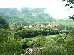 View at Martin Brod | |
 Martin Brod | |
| Coordinates: 44°29′19.8″N 16°08′30.7″E / 44.488833°N 16.141861°E | |
| Country | |
| Entity | Federation of Bosnia and Herzegovina |
| Canton | |
| Municipality | |
| Area | |
| • Total | 1.49 sq mi (3.85 km2) |
| Elevation | 1,080 ft (330 m) |
| Population (2013) | |
| • Total | 124 |
| • Density | 83/sq mi (32/km2) |
| Time zone | UTC+1 (CET) |
| • Summer (DST) | UTC+2 (CEST) |
Martin Brod (Serbian Cyrillic: Мартин Брод) is a village in the municipality of Bihać, Bosnia and Herzegovina. It is mostly known for its proximity to Una National Park, which is Bosnia and Herzegovina's largest national park.[1]
Demographics
According to the 2013 census, its population was 124.[2]
| Ethnicity | Number | Percentage |
|---|---|---|
| Serbs | 120 | 97.5% |
| Bosniaks | 1 | 0.2% |
| other/undeclared | 3 | 2.3% |
| Total | 124 | 100% |
Gallery
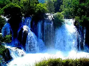 Waterfall on Una river in the Martin Brod
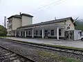 Railway station
References
- ↑ Official results from the book: Ethnic composition of Bosnia-Herzegovina population, by municipalities and settlements, 1991. census, Zavod za statistiku Bosne i Hercegovine - Bilten no.234, Sarajevo 1991.
- ↑ "Naseljena Mjesta 1991/2013" (in Bosnian). Statistical Office of Bosnia and Herzegovina. Retrieved August 7, 2021.
Wikimedia Commons has media related to Martin Brod.
This article is issued from Wikipedia. The text is licensed under Creative Commons - Attribution - Sharealike. Additional terms may apply for the media files.