| Marree Mosque | |
|---|---|
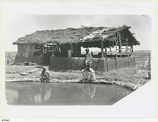
 The Mosque at Hergott Springs. The pool in the foreground was used by worshippers for washing their feet before entering the Mosque. | |
| Religion | |
| Affiliation | Islam (former) |
| Ecclesiastical or organizational status | Mosque (former) |
| Status | Active |
| Location | |
| Location | Marree, South Australia, Australia |
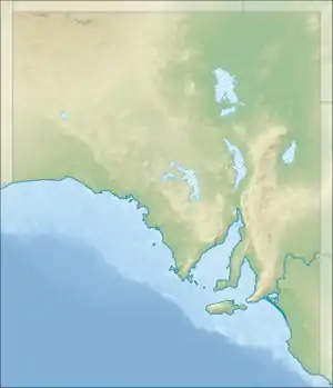
 Location in South Australia | |
| Geographic coordinates | 29°39′05″S 138°03′47″E / 29.651346°S 138.063082°E |
| Architecture | |
| Founder | Abdul Kadir |
| Completed | c. 1882 |
| Part of a series on |
| Islam in Australia |
|---|
 |
| History |
|
| Mosques |
| Organisations |
| Islamic organisations in Australia |
| Groups |
| Events |
| National Mosque Open Day |
| People |
|
The Marree Mosque is a former mosque located in Marree, South Australia, Australia.
History
The mosque was completed in c. 1882 (some sources indicate as early as 1861[1]), by members of the South Australian Afghan community.[2] These "Afghans" were generally Muslims from then-British India, although some came from Afghanistan and the Middle East. They worked as cameldrivers and breeders in the region.[3] Figures indicate an approximation that 3,000 "Ghans" were involved in this type of work until it was overtaken by the car and train in the 1930s.[2][3]
The mosque was constructed by camel breeder Abdul Kadir, owner of Wangamanna Station.[4] Another cameleer, Mullah Assim Khan, became imam of the Marree mosque in the early 20th century. The town had two mosques for some time, before the northern one was abandoned around 1910.[5] Another report indicates that a mosque was deliberately demolished in 1956 by its elderly caretaker, Syed Goolamdeen, who could no longer maintain it.[6]
As of 2003, it was reported in one source that the descendants of the Afghans in Marree have rebuilt the mosque.[2] However, a heritage survey funded by the Australian and South Australian governments and which was conducted from April 2001 to June 2002 reveals that the mosque no longer exists apart from an area of prepared ground and post stubs, and the nearby remains of an enclosure for camels. The report of the heritage survey which was published in 2002 reports that a "replica mosque" had been built within the Marree township.[7]: 263, 267 & 534 A tourist map published in 2018 shows a mosque within a park called the "Afghan Camellier Park" (sic) located within the alignment of the former Central Australia Railway which passed through the town.[8]
See also
References
- ↑ Australia. Parliament. Senate. Parliamentary debates (Hansard).: Senate. Commomwealth Govt. Printer. Retrieved 9 September 2012.
- 1 2 3 Adler, Leonore Loeb; Gielen, Uwe P. (2003). Migration: Immigration and Emigration in International Perspective. Greenwood Publishing Group. pp. 278–. ISBN 978-0-275-97666-8. Retrieved 9 September 2012.
- 1 2 Adler, Leonore Loeb & Gielen, Uwe P. (2003). Migration: Immigration and Emigration in International Perspective. Greenwood Publishing Group. ISBN 9780275976668. Retrieved 15 March 2015.
- ↑ Wilson, Pip (30 October 2006). Faces in the Street. Lulu.com. pp. 546–. ISBN 978-1-4303-0021-2. Retrieved 9 September 2012.
- ↑ Jones, Philip; Kenny, Anna (1 February 2010). Australia's Muslim Cameleers: Pioneers of the Inland, 1860s-1930s. Wakefield Press. pp. 124–. ISBN 978-1-86254-872-5. Retrieved 9 September 2012.
- ↑ Migration Museum (22 May 1995). From many places: the history and cultural traditions of South Australian people. Wakefield Press. ISBN 978-1-86254-347-8. Retrieved 9 September 2012.
- ↑ Leader-Elliott, Lyn; Iwanicki, Iris (2002), Heritage of the Birdsville and Strzelecki Tracks : part of the Far North & Far West Region (Region 13) (PDF), South Australian Dept. for Environment and Heritage, pp. 263–272 & 534, ISBN 978-0-646-42140-7
- ↑ "Marree, the corrugated iron town (map)". Welcome to Marree. Retrieved 21 June 2019.
Further reading
- Australia's First Muslims at ArdernObservations blogspot