Mamberamo Raya Regency
Kabupaten Mamberamo Raya | |
|---|---|
 Coat of arms | |
| Motto: Mecom Cirimo Ecipiri Punum Mate | |
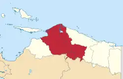 Location in Papua Province | |
 Mamberamo Raya Regency Location in Indonesian Papua  Mamberamo Raya Regency Location in Indonesia | |
| Coordinates: 2°14′08″S 137°46′56″E / 2.2356°S 137.7823°E | |
| Country | |
| Province | Papua |
| Capital | Burmeso |
| Government | |
| • Regent | Dorinus Dasinapa |
| • Vice Regent | Yakobus Britay |
| Area | |
| • Total | 23,813.91 km2 (9,194.60 sq mi) |
| Population (mid 2022 estimate)[1] | |
| • Total | 37,616 |
| • Density | 1.6/km2 (4.1/sq mi) |
| Time zone | UTC+9 (Indonesia Eastern Time) |
| Area code | (+62) 969 |
| Website | mamberamorayakab.go.id |
Mamberamo Raya Regency is one of the regencies (kabupaten) in Papua Province, Indonesia; it was created on 15 March 2007 from parts of Sarmi Regency and Waropen Regency. It covers an area of 23,813.91 km2, and had a population of 18,365 at the 2010 Census[2] which had virtually doubled to 36,483 at the 2020 Census;[3] the official estimate as at mid 2022 was 37,616.[1] The administrative centre is at the town of Burmeso in Mamberamo Tengah District.
Languages
Languages spoken in Mamberamo Raya Regency:[4]
Administrative Districts
At the 2010 Census the regency comprised eight districts (distrik), tabulated below with their areas and their populations at the 2010 Census[2] and the 2020 Census,[3] together with the official estimates as at mid 2022.[1] The table also includes the locations of the district administrative centres, the number of administrative villages (kampung) in each district, and its post code. A ninth district (Iwaso, with its district centre at Metaweja) has recently been created, but no figures for its area or 2010 population are available.
| Kode Wilayah | Name of District (distrik) | Area in km2 | Pop'n 2010 Census | Pop'n 2020 Census | Pop'n mid 2022 Estimate | Admin centre | No. of villages | Post code |
|---|---|---|---|---|---|---|---|---|
| 91.20.06 | Waropen Atas | 2,935 | 2,876 | 5,413 | 5,447 | Barapasi | 7 | 98681 |
| 91.20.07 | Benuki | 2,636 | 1,183 | 2,425 | 2,495 | Gesa Baru | 8 | 98683 |
| 91.20.08 | Sawai (a) | 3,183 | 2,346 | 3,883 | 3,989 | Poiwai | 6 | 98682 |
| 91.20.05 | Mamberamo Hilir (Lower Mamberamo) | 2,078 | 1,734 | 3,330 | 3,387 | Trimuris | 7 | 98691 |
| 91.20.01 | Mamberamo Tengah (b) (Central Mamberamo) | 2,491 | 3,158 | 8,037 | 8,740 | Kasonaweja | 11 | 98692 |
| 91.20.09 | Iwaso | (c) | (c) | 541 | 553 | Metaweja | (c) | 98692 |
| 91.20.04 | Mamberamo Tengah Timur (East Central Mamberamo) | 2,429 | 1,551 | 2,940 | 2,980 | Kustra | 7 | 98693 |
| 91.20.03 | Rufaer | 3,514 | 2,546 | 4,909 | 4,992 | Kai (Kay Seta) | 6 | 98695 |
| 91.20.02 | Mamberamo Hulu (Upper Mamberamo) | 4,548 | 2,971 | 5,002 | 5,033 | Dabra | 8 | 98694 |
| Totals | 23,814 | 18,365 | 36,483 | 37,616 | Bermeso | 60 |
Note: (a) includes the offshore islands of Pulau Kumkum and Pulau Poiwai. (b) Mamberamo Tengah District listed here should not be confused with Mamberamo Tengah Regency (now part of the province of Highland Papua), which lies to the southeast of Mamberamo Raya Regency. (c) the area and 2010 Population of the new Iwaso District, and the number of villages in the district, are included in the figures for Mamberamo Tengah District, from which it was cut out.
References
- 1 2 3 Badan Pusat Statistik, Jakarta, 2023, Kabupaten Mamberamo Raya Dalam Angka 2023 (Katalog-BPS 1102001.9120)
- 1 2 Biro Pusat Statistik, Jakarta, 2011.
- 1 2 Badan Pusat Statistik, Jakarta, 2021.
- ↑ Eberhard, David M.; Simons, Gary F.; Fennig, Charles D., eds. (2019). "Indonesia languages". Ethnologue: Languages of the World (22nd ed.). Dallas: SIL International.