Mamak | |
|---|---|
District and municipality | |
 | |
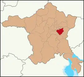 Map showing Mamak District in Ankara Province | |
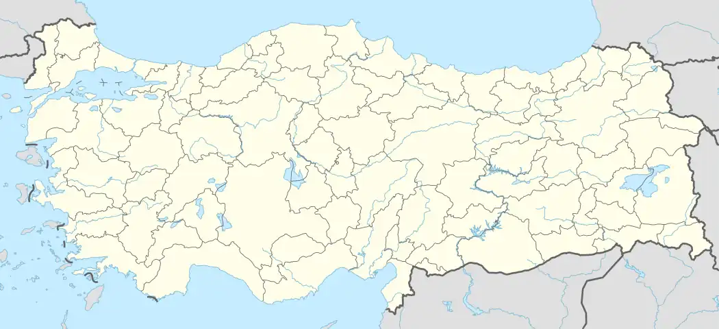 Mamak Location in Turkey  Mamak Mamak (Turkey Central Anatolia) | |
| Coordinates: 39°56′32″N 32°55′23″E / 39.94222°N 32.92306°E | |
| Country | Turkey |
| Province | Ankara |
| Government | |
| • Mayor | Murat Köse (AKP) |
| Area | 321 km2 (124 sq mi) |
| Elevation | 950 m (3,120 ft) |
| Population (2022)[1] | 687,535 |
| • Density | 2,100/km2 (5,500/sq mi) |
| Time zone | TRT (UTC+3) |
| Postal code | 06260 |
| Area code | 0312 |
| Website | www |
Mamak is a municipality and metropolitan district of Ankara Province, Turkey.[2] Its area is 321 km2,[3] and its population is 687,535 (2022).[1] It is part of the city of Ankara. Its elevation is 950 m (3,117 ft).
Important public buildings include an infamous military prison which has been the subject of legend; the military electronic surveillance centre; and Ankara's largest rubbish dump.
Demographics
| Year | Pop. | ±% p.a. |
|---|---|---|
| 2007 | 503,663 | — |
| 2012 | 559,597 | +2.13% |
| 2017 | 637,935 | +2.66% |
| 2022 | 687,535 | +1.51% |
| Source: TÜIK (2007-2022)[1] | ||
Composition
There are 64 neighbourhoods in Mamak District:[4]
- Abidinpaşa
- Akdere
- Akşemsettin
- Altıağaç
- Altınevler
- Araplar
- Aşık Veysel
- Bahçeleriçi
- Bahçelerüstü
- Balkiraz
- Başak
- Bayındır
- Boğaziçi
- Bostancık
- Büyükkayaş
- Çağlayan
- Cengizhan
- Çiğiltepe
- Demirlibahçe
- Derbent
- Diriliş
- Dostlar
- Durali Alıç
- Dutluk
- Ege
- Ekin
- Fahri Korutürk
- General Zeki Doğan
- Gökçeyurt
- Gülveren
- Harman
- Hürel
- Hüseyingazi
- Karaağaç
- Karşıyaka
- Kartaltepe
- Kazım Orbay
- Kıbrısköy
- Kızılca
- Köstence
- Küçük Kayaş
- Kusunlar
- Kutlu
- Kutludüğün
- Lalahan
- Mehtap
- Misket
- Mutlu
- Ortaköy
- Peyami Safa
- Şafaktepe
- Şahap Gürler
- Şahintepe
- Saimekadın
- Şehit Cengiz Topel
- Şirintepe
- Tepecik
- Türközü
- Tuzluçayır
- Üreğil
- Yeni Bayındır
- Yeşilbayır
- Yukarı Imrohor
- Zirvekent
Notable people
- Kübra Öztürk (born 1991), Woman Grandmaster of chess
- Mustafa Yılmaz (born 1992), Grandmaster of chess
References
- 1 2 3 "Population Of SRE-1, SRE-2, Provinces and Districts". TÜIK. Retrieved 29 June 2023.
- ↑ Büyükşehir İlçe Belediyesi, Turkey Civil Administration Departments Inventory. Retrieved 8 June 2023.
- ↑ "İl ve İlçe Yüz ölçümleri". General Directorate of Mapping. Retrieved 22 May 2023.
- ↑ Mahalle, Turkey Civil Administration Departments Inventory. Retrieved 22 May 2023.
External links
- District governor's official website (in Turkish)
- District municipality's official website (in Turkish)
- Kenthaber.com. "General information on Mamak, Ankara" (in Turkish). Archived from the original on 2011-07-19.
Mamak, Ankara in Ankara Province of Turkey | |||||||||||||||||||||||||||
|---|---|---|---|---|---|---|---|---|---|---|---|---|---|---|---|---|---|---|---|---|---|---|---|---|---|---|---|
| Districts | 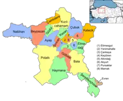 Districts of Ankara | ||||||||||||||||||||||||||
| |||||||||||||||||||||||||||
Metropolitan municipalities are bolded. | |||||||||||||||||||||||||||
This article is issued from Wikipedia. The text is licensed under Creative Commons - Attribution - Sharealike. Additional terms may apply for the media files.