This article contains a list of volcanoes in the United States and its territories.

Alaska

NameElevationLocationLast eruption
metersfeetCoordinates
Mount Adagdak645211551°59′16″N 176°35′30″W / 51.98778°N 176.59167°W / 51.98778; -176.59167 (Mount Adagdak)210,000 ± 5,000 years ago
Mount Akutan1303427554°8′4″N 165°59′10″W / 54.13444°N 165.98611°W / 54.13444; -165.98611 (Mount Akutan)1996
Alagogshak1675549559°09′26″N 155°23′54″W / 59.15722°N 155.39833°W / 59.15722; -155.39833 (Alagogshak)43,000 ± 8,000 years ago
Amak Volcano488160155°25′26″N 163°8′57″W / 55.42389°N 163.14917°W / 55.42389; -163.14917 (Mount Amak)1796
Mount Amukta1066349752°30′0″N 171°15′8″W / 52.50000°N 171.25222°W / 52.50000; -171.25222 (Mount Amukta)1997
Mount Aniakchak1341440056°53′0″N 158°10′0″W / 56.88333°N 158.16667°W / 56.88333; -158.16667 (Mount Aniakchak)1931
Mount Augustine1252410859°21′48″N 153°26′0″W / 59.36333°N 153.43333°W / 59.36333; -153.43333 (Mount Augustine)2005
Black Peak1032338556°33′11″N 158°47′12″W / 56.55306°N 158.78667°W / 56.55306; -158.78667 (Black Peak)1900 BCE ± 150 years
Bogoslof Island15049253°56′0″N 168°2′0″W / 53.93333°N 168.03333°W / 53.93333; -168.03333 (Bogoslof Island)2017
Buldir Volcano656215252°21′0″N 175°54′38″W / 52.35000°N 175.91056°W / 52.35000; -175.91056 (Mount Buldir)Holocene
Mount Bona500516,42161°23′6″N 141°45′3″W / 61.38500°N 141.75083°W / 61.38500; -141.75083 (Mount Bona)847
Mount Blackburn499616,39061°43′54″N 143°25′59″W / 61.73167°N 143.43306°W / 61.73167; -143.433063.4 million years ago
Buzzard Creek830272364°3′40″N 148°24′55″W / 64.06111°N 148.41528°W / 64.06111; -148.41528 (Buzzard Creek)1050 BC
Capital Mountain2356772862°26′N 144°06′W / 62.43°N 144.10°W / 62.43; -144.10 (Capital)1.02 million years ago[1]
Mount Carlisle1620531552°53′38″N 170°3′15″W / 52.89389°N 170.05417°W / 52.89389; -170.05417 (Mount Carlisle)1987
Chagulak Island1142374752°34′36″N 171°8′0″W / 52.57667°N 171.13333°W / 52.57667; -171.13333 (Mount Chagulak)Unknown
Mount Chiginagak2221728757°8′6″N 156°59′24″W / 57.13500°N 156.99000°W / 57.13500; -156.99000 (Mount Chiginagak)1998
Mount Cleveland1730567652°49′30″N 169°56′38″W / 52.82500°N 169.94389°W / 52.82500; -169.94389 (Mount Cleveland)2020[2]
Mount Dana1354444255°38′28″N 161°12′50″W / 55.64111°N 161.21389°W / 55.64111; -161.21389 (Mount Dana)1890 BC
Davidof Volcano328107651°57′15″N 178°19′34″E / 51.9542°N 178.326°E / 51.9542; 178.326 (Davidof Volcano)Probably Holocene
Mount Denison2318760658°25′4″N 154°26′57″W / 58.41778°N 154.44917°W / 58.41778; -154.44917 (Mount Denison)Probably Holocene
Devils Desk1954640958°30′N 154°18′W / 58.5°N 154.3°W / 58.5; -154.3 (Devils Desk)245,000 years ago
Double glacier volcano1239406560°41′N 152°37′W / 60.68°N 152.62°W / 60.68; -152.62 (Double Glacier)Pleistocene
Mount Douglas2140702158°51′19″N 153°32′31″W / 58.85528°N 153.54194°W / 58.85528; -153.54194 (Mount Douglas)Probably Holocene
Mount Dutton1506494155°10′5″N 162°16′18″W / 55.16806°N 162.27167°W / 55.16806; -162.27167 (Mount Dutton)Holocene
Mount Edgecumbe970313257°3′0″N 135°45′0″W / 57.05000°N 135.75000°W / 57.05000; -135.75000 (Mount Edgecumbe)2220 BC ± 100 years
Mount Emmons1436471155°20′26″N 164°4′43″W / 55.34056°N 164.07861°W / 55.34056; -164.07861 (Mount Emmons)More than 10,000 years ago[3]
Espenberg66°21′N 164°20′W / 66.35°N 164.33°W / 66.35; -164.33 (Espenberg)17,500 years BP
Mount Fisher1112364854°39′0″N 164°26′0″W / 54.65000°N 164.43333°W / 54.65000; -164.43333 (Mount Fisher)1830
Fourpeaked2105690658°46′12″N 153°40′20″W / 58.77000°N 153.67222°W / 58.77000; -153.67222 (Fourpeaked)2006
Frosty Peak Volcano1920629955°04′55″N 162°53′38″W / 55.082°N 162.894°W / 55.082; -162.894 (Cold Bay Volcano)Late Pleistocene or later
Gareloi Volcano1573516151°47′25″N 178°47′38″W / 51.79028°N 178.79389°W / 51.79028; -178.79389 (Mount Gareloi)1989
Mount Gilbert818268454°15′08″N 165°39′43″W / 54.2521°N 165.662°W / 54.2521; -165.662 (Mount Gilbert)Unknown, fumaroles until 1948[4]
Great Sitkin1740570952°4′34″N 176°7′48″W / 52.07611°N 176.13000°W / 52.07611; -176.13000 (Great Sitkin)Ongoing
Mount Gordon2755903962°8′0″N 143°5′0″W / 62.13333°N 143.08333°W / 62.13333; -143.08333 (Mount Gordon)Holocene
Mount Griggs2317760258°21′14″N 155°5′30″W / 58.35389°N 155.09167°W / 58.35389; -155.09167 (Mount Griggs)1790 BC ± 40 years
Hayes Volcano3034995461°38′25″N 152°24′41″W / 61.64028°N 152.41139°W / 61.64028; -152.41139 (Hayes Volcano)1200 ± 300 years
Mount Herbert1280419952°44′32″N 170°6′38″W / 52.74222°N 170.11056°W / 52.74222; -170.11056 (Mount Herbert)Unknown
Mount Iliamna305310,01660°1′55″N 153°5′25″W / 60.03194°N 153.09028°W / 60.03194; -153.09028 (Mount Iliamna)1876
Imuruk Lake610200165°36′0″N 163°55′0″W / 65.60000°N 163.91667°W / 65.60000; -163.91667 (Imuruk Lake)300
Ingakslugwat Hills19062361°26′0″N 164°28′0″W / 61.43333°N 164.46667°W / 61.43333; -164.46667 (Ingakslugwat Hills)Holocene
Isanotski Peaks2446802554°45′54″N 163°43′21″W / 54.76500°N 163.72250°W / 54.76500; -163.72250 (Mount Isanotski)Unknown
Kagamil Island893293052°58′25″N 169°43′0″W / 52.97361°N 169.71667°W / 52.97361; -169.71667 (Mount Kagamil)1929
Mount Kaguyak901295658°36′30″N 154°1′40″W / 58.60833°N 154.02778°W / 58.60833; -154.02778 (Mount Kaguyak)1650 BC
Mount Kanaga1307428851°55′22″N 177°10′4″W / 51.92278°N 177.16778°W / 51.92278; -177.16778 (Mount Kanaga)2012
Kasatochi Island314103052°10′39″N 175°30′30″W / 52.17750°N 175.50833°W / 52.17750; -175.50833 (Kasatochi Island)2008
Mount Katmai2047671658°16′47″N 154°57′48″W / 58.27972°N 154.96333°W / 58.27972; -154.96333 (Mount Katmai)1912
Kejulik Volcano1517497758°01′33″N 155°39′17″W / 58.02583°N 155.65472°W / 58.02583; -155.65472 (Kejulik Volcano)Unknown
Mount Kialagvik1575516757°12′10″N 156°44′43″W / 57.20278°N 156.74528°W / 57.20278; -156.74528 (Mount Kialagvik)Holocene[5]
Kiska Volcano1220400352°06′11″N 177°36′13″E / 52.1031°N 177.6035°E / 52.1031; 177.6035 (Mount Kiska)1990
Koniuji Island27389652°13′0″N 175°8′0″W / 52.21667°N 175.13333°W / 52.21667; -175.13333 (Mount Koniuji)1150 BC
Korovin Volcano1533502952°22′54″N 174°9′57″W / 52.38167°N 174.16583°W / 52.38167; -174.16583 (Korovin Volcano)2007
Mount Kukak2043670358°27′10″N 154°21′18″W / 58.45278°N 154.35500°W / 58.45278; -154.35500 (Mount Kukak)Holocene[6]
Mount Kupreanof1895621756°0′40″N 159°47′50″W / 56.01111°N 159.79722°W / 56.01111; -159.79722 (Mount Kupreanof)1987
Kookooligit Mountains673220863°36′0″N 170°26′0″W / 63.60000°N 170.43333°W / 63.60000; -170.43333 (Kookooligit Mountains)Holocene
Little Sitkin1174385251°57′0″N 178°32′35″W / 51.95000°N 178.54306°W / 51.95000; -178.54306 (Little Sitkin)1830
Mount Mageik2165710358°11′41″N 155°15′10″W / 58.19472°N 155.25278°W / 58.19472; -155.25278 (Mount Mageik)500 BC ± 50 years
Mount Makushin1800590553°53′27″N 165°55′22″W / 53.89083°N 165.92278°W / 53.89083; -165.92278 (Mount Makushin)1995
Mount Martin1863611258°10′20″N 155°21′40″W / 58.17222°N 155.36111°W / 58.17222; -155.36111 (Mount Martin)1953
Mount Moffett1196392451°56′38″N 176°44′48″W / 51.94389°N 176.74667°W / 51.94389; -176.74667 (Monte Moffett)1600 BC
Novarupta841275958°16′0″N 155°9′24″W / 58.26667°N 155.15667°W / 58.26667; -155.15667 (Novarupta)1912
Nunivak Island511167660°1′0″N 166°20′0″W / 60.01667°N 166.33333°W / 60.01667; -166.33333 (Nunivak Island)300,000 years ago
Mount Okmok1073352053°26′0″N 168°8′0″W / 53.43333°N 168.13333°W / 53.43333; -168.13333 (Mount Okmok)2008
St. Michael volcanic field715234663°27′0″N 162°7′0″W / 63.45000°N 162.11667°W / 63.45000; -162.11667 (Saint Michael (volcano))More recent than 500 BC
Saint Paul Island20366657°11′0″N 170°18′0″W / 57.18333°N 170.30000°W / 57.18333; -170.30000 (Saint Paul Island)1280 BC ± 40 years
Mount Pavlof2519826455°25′0″N 161°53′15″W / 55.41667°N 161.88750°W / 55.41667; -161.88750 (Mount Pavlof)2022
Pavlof Sister2142702755°27′10″N 161°50′35″W / 55.45278°N 161.84306°W / 55.45278; -161.84306 (Pavlof Sister)1786
Pogromni2002656954°34′N 164°51′W / 54.57°N 164.85°W / 54.57; -164.85 (Pogromni)Late Pleistocene[7]
Pyre Peak1054345852°18′55″N 172°35′30″W / 52.31528°N 172.59167°W / 52.31528; -172.59167 (Mount Seguam)1993
Mount Recheschnoi1984650953°9′24″N 168°32′20″W / 53.15667°N 168.53889°W / 53.15667; -168.53889 (Mount Recheschnoi)3,000 years ago
Mount Redoubt310810,19760°29′7″N 152°44′31″W / 60.48528°N 152.74194°W / 60.48528; -152.74194 (Mount Redoubt)2009
Roundtop Mountain1871613854°48′0″N 163°35′20″W / 54.80000°N 163.58889°W / 54.80000; -163.58889 (Mount Roundtop)9,100-10,000 years ago[8]
Mount Sanford494916,23762°13′0″N 144°8′0″W / 62.21667°N 144.13333°W / 62.21667; -144.13333 (Mount Sanford)320,000 years ago
Mount Segula1160380652°0′55″N 178°8′8″W / 52.01528°N 178.13556°W / 52.01528; -178.13556 (Mount Segula)A few hundred years ago
Semisopochnoi Island1221400651°56′0″N 179°35′0″W / 51.93333°N 179.58333°W / 51.93333; -179.58333 (Mount Semisopochnoi)2023
Mount Sergief560183752°2′0″N 174°56′0″W / 52.03333°N 174.93333°W / 52.03333; -174.93333 (Mount Sergief)Pleistocene[9]
Mount Shishaldin2857937354°45′20″N 163°58′0″W / 54.75556°N 163.96667°W / 54.75556; -163.96667 (Mount Shishaldin)Ongoing
Snowy Mountain2162709358°20′8″N 154°40′55″W / 58.33556°N 154.68194°W / 58.33556; -154.68194 (Snowy Mountain)1710 ± 200 years
Mount Spurr337411,06961°17′58″N 152°15′4″W / 61.29944°N 152.25111°W / 61.29944; -152.25111 (Mount Spurr)1992
St. Michael volcanic field715234663°27′0″N 162°7′0″W / 63.45000°N 162.11667°W / 63.45000; -162.11667 (St. Michael)Within 3,000 years
St. Paul Island20366657°11′0″N 170°18′0″W / 57.18333°N 170.30000°W / 57.18333; -170.30000 (St. Paul Island)1280 BC ± 40 years
Mount Steller2272745458°26′0″N 154°24′0″W / 58.43333°N 154.40000°W / 58.43333; -154.40000 (Mount Steller)Probably Holocene
Stepovak Bay 31555510255°56′0″N 160°0′0″W / 55.93333°N 160.00000°W / 55.93333; -160.00000 (Mount Stepovak)Probably Pleiocene
Table Top-Wide Bay792259853°58′5″N 166°40′38″W / 53.96806°N 166.67722°W / 53.96806; -166.67722 (Table Top-Wide Bay)Holocene[10]
Mount Takawangha1449475451°52′22″N 178°0′20″W / 51.87278°N 178.00556°W / 51.87278; -178.00556 (Mount Takawangha)Last few hundred years[11]
Tana (volcano)1170383952°49′48″N 169°16′12″W / 52.83000°N 169.27000°W / 52.83000; -169.27000 (Tana (volcano))Mid-late Holocene[12]
Mount Tanaga1806592551°53′6″N 178°8′45″W / 51.88500°N 178.14583°W / 51.88500; -178.14583 (Mount Tanaga)1914
Tlevak Strait-Suemez Island5016455°15′0″N 133°18′0″W / 55.25000°N 133.30000°W / 55.25000; -133.30000 (Tlevak Strait-Suemez Island)Holocene/Post-glacial[13]
Trident Volcano1864611558°14′8″N 155°6′0″W / 58.23556°N 155.10000°W / 58.23556; -155.10000 (Trident Volcano)1975
Ugashik-Peulik1474483657°45′3″N 156°22′5″W / 57.75083°N 156.36806°W / 57.75083; -156.36806 (Ugashik-Peulik)1814
Ukinrek Maars9129957°49′54″N 156°30′35″W / 57.83167°N 156.50972°W / 57.83167; -156.50972 (Ukinrek Maars)1977
Uliaga Island888291353°3′54″N 169°46′0″W / 53.06500°N 169.76667°W / 53.06500; -169.76667 (Mount Uliaga)Holocene
Mount Veniaminof2507822556°10′0″N 159°23′0″W / 56.16667°N 159.38333°W / 56.16667; -159.38333 (Mount Veniaminof)2021
Mount Vsevidof2149705053°7′48″N 168°41′35″W / 53.13000°N 168.69306°W / 53.13000; -168.69306 (Mount Vsevidof)1957
Mount Westdahl1654542654°31′6″N 164°39′0″W / 54.51833°N 164.65000°W / 54.51833; -164.65000 (Mount Westdahl)1992
Yantarni Volcano1345441357°1′17″N 157°11′6″W / 57.02139°N 157.18500°W / 57.02139; -157.18500 (Yantarni Volcano)800 BC ± 500 years
Yunaska Island550180452°38′34″N 170°37′43″W / 52.64278°N 170.62861°W / 52.64278; -170.62861 (Mount Yunaska)1937
Prindle Volcano--63°43′N 141°37′W / 63.72°N 141.62°W / 63.72; -141.62 (Prindle Volcano)Pleistocene
Mount Churchill476615,63261°15′N 141°42′W / 61.25°N 141.7°W / 61.25; -141.7 (Mount Churchill)700 ± 200 years
Mount Drum366112,01062°06′N 144°30′W / 62.1°N 144.5°W / 62.1; -144.5 (Mount Drum)About 250,000 years ago[14]
Mount Jarvis409113,42262°1′4″N 143°37′2″W / 62.01778°N 143.61722°W / 62.01778; -143.61722 (Mount Jarvis)1 million years ago
Mount Wrangell431714,16362°00′N 144°01′W / 62.00°N 144.02°W / 62.00; -144.02 (Mount Wrangell)1999

American Samoa

NameElevationLocationLast eruption
metersfeetCoordinates
MalumaluLast 8,000 years
Ta‘u-931305414°13′48″S 169°27′14″W / 14.23°S 169.454°W / -14.23; -169.454 (Ta‘u-)30,000 years ago[15]
Ofu-Olosega639209614°10′30″S 169°37′05″W / 14.175°S 169.618°W / -14.175; -169.618 (Ofu-Olosega)1866 unnamed submarine cone eruption
Tutuila653214214°17′42″S 170°42′00″W / 14.295°S 170.70°W / -14.295; -170.70 (Tutuila)440 CE[16]
Vailulu'u-592-184214°17′42″S 170°42′00″W / 14.295°S 170.70°W / -14.295; -170.70 (Vailulu'u)2003 west of unnamed submarine caldera and nafauna


Arizona

NameElevationLocationLast eruption
metersfeetCoordinates
Arlington Cone - - 33°20′55.6″N 112°44′54.2″W / 33.348778°N 112.748389°W / 33.348778; -112.748389 -
Black Bottom Crater--35°23′54.02″N 111°23′42.55″W / 35.3983389°N 111.3951528°W / 35.3983389; -111.3951528-
Colton Crater2,2467,36835°32′42″N 111°38′13.2″W / 35.54500°N 111.637000°W / 35.54500; -111.637000 (Colton Crater)1075 AD Sunset Crater and Unnamed Fissure vents
Double Crater2,4267,95935°20′34.03″N 111°26′51.55″W / 35.3427861°N 111.4476528°W / 35.3427861; -111.4476528 (Double Crater)Pistocene
Lenox Crater--35°21′35.999″N 111°31′47.62″W / 35.35999972°N 111.5298944°W / 35.35999972; -111.5298944 (Lenox Crater)-
Maroon Crater--35°26′32.02″N 111°28′12.56″W / 35.4422278°N 111.4701556°W / 35.4422278; -111.4701556 (Maroon Crater)-
Merriam Cone2,0776,81335°18′N 111°18′W / 35.300°N 111.300°W / 35.300; -111.300 (Merriam Cone)150,000 years ago
Mount Baldy3,48011,42033°54′22″N 109°33′46″W / 33.90611°N 109.56278°W / 33.90611; -109.562788-9 million years ago
Mount Elden2,8349,29935°14′28″N 111°35′48″W / 35.24111°N 111.59667°W / 35.24111; -111.59667 (Mount Elden)250,000 years ago
Red Mountain2428796535°31′23″N 111°52′32″W / 35.52306°N 111.87556°W / 35.52306; -111.87556740,000 years ago
Roden Crater--35°25′37.02″N 111°15′27.76″W / 35.4269500°N 111.2577111°W / 35.4269500; -111.2577111400,000 years ago
San Francisco Peaks385112,63335°20′47″N 111°40′40″W / 35.34639°N 111.67778°W / 35.34639; -111.67778 (San Francisco Mountain)92,000 years ago[17]
San Francisco volcanic field--35°21′51″N 111°30′11″W / 35.36417°N 111.50306°W / 35.36417; -111.50306 (San Francisco volcanic field)1075 AD ± 25 years
SP Crater2141702135°34′56″N 111°37′55″W / 35.58222°N 111.63194°W / 35.58222; -111.63194 (SP Crater)5,500 years ago
Stewart Crater--35°21′39.6″N 111°24′14.4″W / 35.361000°N 111.404000°W / 35.361000; -111.404000 (Stewart Crater)-
Strawberry Crater1,9896,52635°26′32.02″N 111°28′12.6″W / 35.4422278°N 111.470167°W / 35.4422278; -111.470167 (Double Strawberry Crater)Late Pleistocene
Sunset Crater (San Francisco volcanic field)2447802635°21′51″N 111°30′11″W / 35.36417°N 111.50306°W / 35.36417; -111.50306 (Sunset Crater)1075 AD ± 25 years
Uinkaret volcanic field--36°13′7.93″N 113°4′38.74″W / 36.2188694°N 113.0774278°W / 36.2188694; -113.0774278 (Uinkaret volcanic field)1100 AD ± 75 years Little Springs Pyroclastic Cone

California

NameElevationLocationLast eruption
metersfeetCoordinates
Amboy Crater-

300

-

984

-

34°32′38″N 115°47′28″W / 34.54389°N 115.79111°W / 34.54389; -115.79111 (Amboy Crater)

23 million years ago 79,000 ± 5,000 years ago
Big Cave1259413140°57′18″N 121°21′54″W / 40.955°N 121.365°W / 40.955; -121.365 (Big Cave)38,000 ± 7,000 years ago
Big Pine volcanic field37°00′N 118°15′W / 37.000°N 118.250°W / 37.000; -118.250 (Big Pine volcanic field)17,000 years ago
Black Butte1939636241°22′01″N 121°20′53″W / 41.367°N 121.348°W / 41.367; -121.348 (Black Butte)9,500 years ago
Brushy Butte1174385241°10′41″N 121°26′35″W / 41.178°N 121.443°W / 41.178; -121.443 (Brushy Butte)12,000 years ago
Burney Mountain2397786340°49′N 121°38′W / 40.81°N 121.63°W / 40.81; -121.63 (Burney Mountain)280,000 ± 6,000 years ago[18]
Cima volcanic field1509692535°15′N 115°45′W / 35.25°N 115.75°W / 35.25; -115.75 (Cima Volcanic Field)15,000 ± 5,000 years ago
Cinder Cone and the Fantastic Lava Beds2105690740°33′N 121°19′W / 40.55°N 121.32°W / 40.55; -121.321666
Inyo Craters2629862537°41′31″N 119°01′12″W / 37.692°N 119.02°W / 37.692; -119.02 (Inyo Craters)1380 CE ± 50 years
Mount Konocti (Clear Lake Volcanic Field)1312430538°58′N 122°46′W / 38.97°N 122.77°W / 38.97; -122.77 (California Coast Range)11,000 years ago
Lassen Peak318910,46240°29′17″N 121°30′18″W / 40.48806°N 121.50500°W / 40.48806; -121.50500 (Lassen Peak)1917
Lassen Volcanic Center--40°29′30″N 121°30′30″W / 40.49167°N 121.50833°W / 40.49167; -121.50833 (Lassen Volcanic Center)1917
Long Valley Caldera339011,12237°36′N 118°48′W / 37.6°N 118.8°W / 37.6; -118.8 (Long Valley Caldera)50,000 years ago
Malapai Hill1304427833°54′N 116°00′W / 33.9°N 116.0°W / 33.9; -116.0 (Malapi Hill)15.93 ± 0.08 million years ago
Mammoth Mountain337111,05937°38′N 119°02′W / 37.63°N 119.03°W / 37.63; -119.03 (Mammoth Mountain)1260 AD ± 40 years
Medicine Lake Volcano2412791341°22′N 121°20′W / 41.36°N 121.33°W / 41.36; -121.33 (Medicine Lake Volcano)1060 AD
Mono Craters2,7969,17337°53′N 119°00′W / 37.88°N 119.00°W / 37.88; -119.00 (Mono Craters)1350 AD ± 20 years
Pinnacles--36°29′13″N 121°10′01″W / 36.487°N 121.167°W / 36.487; -121.167 (Pinnacles)23 million years ago
Pipkin34°41′12″N 116°37′12″W / 34.68667°N 116.62000°W / 34.68667; -116.62000770,000 ± 40,000 years ago
Pisgah Crater7742,53934°44′47″N 116°22′30″W / 34.74639°N 116.37500°W / 34.74639; -116.37500 (Pisgah Crater)18,000 ± 5,000 years ago
Red Cones2,7489,01537°35′N 119°03′W / 37.58°N 119.05°W / 37.58; -119.05 (Red Cones)8,500 years ago
Round Top5381,76437°51′N 122°11′W / 37.85°N 122.19°W / 37.85; -122.19 (Round Top)10 Million Years Ago[19]
Mount Saint Helena1,3234,34238°40′N 122°38′W / 38.67°N 122.63°W / 38.67; -122.63 (Clear Lake Volcanic Field)3.4 million years ago
Mount Shasta4,31714,16241°24′32″N 122°11′35″W / 41.409°N 122.193°W / 41.409; -122.193 (Mount Shasta)1250
Sutter Buttes6502,13039°12′20.61″N 121°49′12.9″W / 39.2057250°N 121.820250°W / 39.2057250; -121.820250 (Sutter Buttes)1.5 million years ago
Tumble Buttes2,1917,18840°41′N 121°33′W / 40.68°N 121.55°W / 40.68; -121.55 (Tumble Buttes)10,000 – 15,000 years ago[20]
Twin Buttes1631535140°47′N 121°36′W / 40.78°N 121.60°W / 40.78; -121.60 (Twin Buttes)10,000 to 15,000 years ago
Ubehebe Craters752246737°01′N 117°27′W / 37.02°N 117.45°W / 37.02; -117.45 (Ubehebe Craters)150 BC

Colorado

NameElevationLocationLast eruption
metersfeetCoordinates
Dotsero2,2307,31639°39′40″N 107°03′22″W / 39.661°N 107.056°W / 39.661; -107.056 (Dotsero)2200 BC ± 300 years
La Garita Caldera4,27414,02237°43′36″N 106°46′28″W / 37.72667°N 106.77444°W / 37.72667; -106.77444 (La Garita Caldera)26.3 Ma
Never Summer Mountains3,94612,94540°28′10″N 105°53′42″W / 40.46944°N 105.89500°W / 40.46944; -105.89500 (Never Summer Mountains)24 to 29 million years ago
Summer Coon--37°46′51″N 106°22′09″W / 37.78083°N 106.36917°W / 37.78083; -106.36917 (Summer Coon)24 to 34 million years ago

Hawaii

NameElevationLocationLast eruption
metersfeetCoordinates
Diamond Head23276121°15′35″N 157°48′42″W / 21.25972°N 157.81167°W / 21.25972; -157.81167 (Diamond Head)400,000 to 500,000 years ago
Haleakalā or East Maui Volcano305510,02320°43′N 156°15′W / 20.71°N 156.25°W / 20.71; -156.25 (Haleakala)1750
Hanauma Bay (Koko Head)19664221°16′17″N 157°41′40″W / 21.27139°N 157.69444°W / 21.27139; -157.69444 (Hanauma Bay)10,000 - 32,000 years ago
Hualalai2521827019°41′N 155°52′W / 19.69°N 155.87°W / 19.69; -155.87 (Hualalai)1801
Kaʻau Crater4621,51621°19′43″N 157°46′21″W / 21.32861°N 157.77250°W / 21.32861; -157.7725035000 or 76000 years ago.
Kaʻena Point--21°34′31″N 158°16′57″W / 21.57528°N 158.28250°W / 21.57528; -158.28250Pleistocene Epoch
Kahoolawe450147520°36′N 156°36′W / 20.6°N 156.6°W / 20.6; -156.6 (Kahoolawe)1 million years ago
Kauhakō Crater15049021°11′16″N 156°57′58″W / 21.18778°N 156.96611°W / 21.18778; -156.96611230,000-300,000 years ago
Kawaikini1,5985,24322°03′24″N 159°29′48″W / 22.05667°N 159.49667°W / 22.05667; -159.496674 million years ago
Kilauea1247409119°27′07″N 155°17′31″W / 19.452°N 155.292°W / 19.452; -155.292 (Kilauea)2023
Kohala (mountain)1670548020°5′10″N 155°43′2″W / 20.08611°N 155.71722°W / 20.08611; -155.71722 (Kohala (mountain))120,000 years ago
Koko Guyot--35°15′N 171°35′E / 35.250°N 171.583°E / 35.250; 171.58350 million years ago
Koko Crater368120721°15′42″N 157°42′11″W / 21.261585°N 157.702949°W / 21.261585; -157.702949 (Koko Head)10,000 years ago
Koʻolau Range941314921°22′N 157°48′W / 21.37°N 157.80°W / 21.37; -157.80 (Koolau)40,000 years ago
Lanai1,0263,36620°50′N 156°56′W / 20.833°N 156.933°W / 20.833; -156.9331.2 million years ago
Kamaʻehuakanaloa Seamount (Loihi)-975-319918°55′N 155°15′W / 18.92°N 155.25°W / 18.92; -155.25 (Loihi Seamount)1996
Māhukona--20°06′N 156°06′W / 20.1°N 156.1°W / 20.1; -156.1 (Mahukona)About 470,000 years ago
Mauna Kea420813,79619°48′N 155°30′W / 19.8°N 155.5°W / 19.8; -155.5 (Mauna Kea)2460 BC ± 100 years
Mauna Loa416913,67919°30′N 155°36′W / 19.5°N 155.6°W / 19.5; -155.6 (Mauna Loa)2022
Mount Waialeale1,5445,06622°04′26″N 159°29′55″W / 22.07389°N 159.49861°W / 22.07389; -159.49861-
Puʻu Hawaiʻiloa10333721°26′53″N 157°45′24″W / 21.44806°N 157.75667°W / 21.44806; -157.75667-
Punchbowl Crater--21°18′45″N 157°50′46″W / 21.31250°N 157.84611°W / 21.31250; -157.84611400,000 to 500,000 years ago
Ulupaʻu Crater20165921°27′16″N 157°43′54″W / 21.45444°N 157.73167°W / 21.45444; -157.73167-
Waianae Range13424,02521°30′25″N 158°08′34″W / 21.50694°N 158.14278°W / 21.50694; -158.142782.6 million years ago
West Maui Volcano1,7645,78820°53′37″N 156°35′22″W / 20.89361°N 156.58944°W / 20.89361; -156.58944320,000 years ago

Idaho

NameElevationLocationLast eruption
metersfeetCoordinates
Big Southern Butte2298754043°14′N 113°01′W / 43.24°N 113.01°W / 43.24; -113.01 (Big Southern Butte)300,000 years ago
Blue Creek----
Craters of the Moon2005657843°25′N 113°30′W / 43.42°N 113.50°W / 43.42; -113.50 (Craters of the Moon)130 BC ± 50 years
Yellowstone Plateau volcanic field2805920344°28′16″N 110°30′07″W / 44.471031°N 110.501862°W / 44.471031; -110.501862 (Yellowstone Plateau)70,000 years ago (magmatic) / 1350 BC ± 200 years (hydrothermal)[21]
Juniper Buttes1905625044°12′N 111°32′W / 44.20°N 111.53°W / 44.20; -111.53 (Juniper Buttes)-
Menan Buttes1713561943°36′N 111°30′W / 43.60°N 111.5°W / 43.60; -111.5 (Menan Buttes)10,000 years ago
Split Butte--44°15′N 111°44′W / 44.25°N 111.73°W / 44.25; -111.73-
The Great Rift--43°27′42″N 113°33′46″W / 43.46167°N 113.56278°W / 43.46167; -113.56278-
Shoshone volcano----

Illinois

NameElevationLocationLast eruption
metersfeetCoordinates
Hicks Dome[22]20366637°32′N 88°22′W / 37.53°N 88.37°W / 37.53; -88.37400-345 million years ago

Louisiana

NameElevationLocationLast eruption
metersfeetCoordinates
Door Point Volcano-2200-7200-74-90 million years ago

Michigan

NameElevationLocationLast eruption
metersfeetCoordinates
Porcupine Mountains Central-Volcano5951,95846°46′52″N 89°40′51″W / 46.78111°N 89.68083°W / 46.78111; -89.680831.093 billion years ago[23]

Mississippi

NameElevationLocationLast eruption
metersfeetCoordinates
Jackson Volcano-880 (from surface)-290032°18′0″N 90°10′19″W / 32.30000°N 90.17194°W / 32.30000; -90.17194 (Jackson Volcano)65 million years ago
Midnight Volcano-1110 (from surface)-364133°02′57″N 90°34′25″W / 33.04904°N 90.573494°W / 33.04904; -90.57349466 million years ago

Missouri

NameElevationLocationLast eruption
metersfeetCoordinates
Taum Sauk Caldera540177237°31′44″N 90°47′10″W / 37.5288°N 90.7862°W / 37.5288; -90.7862 (Taum Sauk Caldera)1.485 billion years ago

Nevada

NameElevationLocationLast eruption
metersfeetCoordinates
Cottonwood Caldera---15.70 million years ago
Crater Flat (Southwest Nevada Volcanic Field)--36°47′N 116°34′W / 36.783°N 116.567°W / 36.783; -116.567 (Crater Flat)80,000 years ago
Indian Peak-Caliente Caldera Complex--38°00′00″N 114°00′00″W / 38.000°N 114.000°W / 38.000; -114.000 (Indian Peak-Caliente Caldera Complex)18 million years ago
Jessup area--39°56′N 118°52′W / 39.933°N 118.867°W / 39.933; -118.867Jurassic
Lunar Crater volcanic field--38°N 116°W / 38°N 116°W / 38; -116 (Lunar Crater volcanic field)38,100 ± 10,000 years ago
McDermitt Caldera2078681642°00′05″N 117°59′48″W / 42.00139°N 117.99667°W / 42.00139; -117.99667 (McDermitt Caldera)16.39 ± 0.02 million years ago
Steamboat Springs1415464239°22′30″N 119°43′12″W / 39.375°N 119.72°W / 39.375; -119.72 (Steamboat Springs)1.14 million years ago
Soda Lakes1251410439°53′N 119°27′W / 39.883°N 119.450°W / 39.883; -119.450 (Soda Lakes)Holocene
Virgin Valley Caldera---16.38 million years ago
Yucca Mountain2044670736°56′N 116°29′W / 36.933°N 116.483°W / 36.933; -116.483 (Yucca Mountain)80,000 years ago

New Hampshire

NameElevationLocationLast eruption
metersfeetCoordinates
Pawtuckaway Mountains--43°06′39″N 71°11′11″W / 43.11083°N 71.18639°W / 43.11083; -71.18639 (Pawtuckaway Mountains)Cretaceous
Ossipee Mountains--43°44′37″N 71°16′26″W / 43.74361°N 71.27389°W / 43.74361; -71.27389 (Ossipee Mountains)Cretaceous

New Jersey

NameElevationLocationLast eruption
metersfeetCoordinates
Rutan Hill3101,02041°14′43″N 74°40′35″W / 41.24528°N 74.67639°W / 41.24528; -74.67639Ordovician

New Mexico

NameElevationLocationLast eruption
metersfeetCoordinates
Albuquerque volcanic field1,8406,03035°8′29″N 106°46′19″W / 35.14139°N 106.77194°W / 35.14139; -106.7719470,000-170,000 years ago
Capulin Volcano2,4948,18236°47′20″N 103°57′42″W / 36.78889°N 103.96167°W / 36.78889; -103.96167 (Capulin Volcano)58,000–52,000 years ago
Carrizozo Malpais1,7315,67933°47′N 105°56′W / 33.78°N 105.93°W / 33.78; -105.93 (Carrizozo Malpais)3,250 BC ± 500 years ago
Cerros del Rio6642,17835°42′N 106°12′W / 35.7°N 106.2°W / 35.7; -106.2 (Cerros del Rio)2.2 million years ago
Jemez Mountains3,525-35°53′N 106°32′W / 35.88°N 106.53°W / 35.88; -106.53 (Jemez Mountains)60,000-50,000 years ago
Jornada del Muerto Volcano1,5655,13633°32′N 106°52′W / 33.533°N 106.867°W / 33.533; -106.867 (Jornada del Muerto Volcano)760,000 years ago
Kilbourne Hole1,5554,24031°58′N 106°58′W / 31.97°N 106.97°W / 31.97; -106.97 (Kilbourne Hole)80,000 years ago
Mount Taylor2,44511,30035°14′19″N 107°36′30″W / 35.23861°N 107.60833°W / 35.23861; -107.60833 (Mount Taylor)1,500,000 years ago
Shiprock2,1887,17736°41′15″N 108°50′10″W / 36.68750°N 108.83611°W / 36.68750; -108.8361127 million years ago
Sierra Blanca3,65211,98133°22′27″N 105°48′31″W / 33.37417°N 105.80861°W / 33.37417; -105.80861 (Sierra Blanca)26 million years ago
Valles Caldera3,43011,25335°52′N 106°34′W / 35.87°N 106.57°W / 35.87; -106.57 (Valles Caldera)50,000 to 60,000 years ago
Zuni-Bandera volcanic field2,5508,36634°48′N 108°00′W / 34.800°N 108.000°W / 34.800; -108.0001,170 BC ± 300 years

Northern Mariana Islands

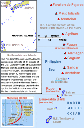
Major volcanoes of the Mariana Islands
NameElevationLocationLast eruption
metersfeetCoordinates
Agrigan965316518°48′N 145°42′E / 18.8°N 145.7°E / 18.8; 145.7 (Agrigan)1917
Ahyi Seamount-137-44920°25′N 145°02′E / 20.42°N 145.03°E / 20.42; 145.03 (Ahyi)2023
Alamagan744244117°36′N 145°50′E / 17.60°N 145.83°E / 17.60; 145.83 (Dante Rodondi)1887
Anatahan788259216°21′N 145°40′E / 16.35°N 145.67°E / 16.35; 145.67 (Veronica Rodondi)2008
Asuncion Island857281019°42′N 145°24′E / 19.7°N 145.4°E / 19.7; 145.4 (Asuncion)1906
Daikoku Seamount-323-106021°19′N 144°11′E / 21.32°N 144.19°E / 21.32; 144.19 (Daikoku)Holocene
Eifuku-1535-503621°29′06″N 144°02′35″E / 21.485°N 144.043°E / 21.485; 144.043 (Eifuku)Holocene
East Diamante-127-41715°56′N 145°40′E / 15.93°N 145.67°E / 15.93; 145.67 (East Diamante)Holocene
Esmeralda Bank-43-14115°00′N 145°15′E / 15.00°N 145.25°E / 15.00; 145.25 (Ashley Rodondi)Holocene
Farallon de Pajaros3601,18020°30′N 144°54′E / 20.5°N 144.9°E / 20.5; 144.9 (Farallon de Pajaros)1967
Forecast Seamount-1456-477713°24′N 143°55′E / 13.4°N 143.92°E / 13.4; 143.92 (Forecast)Holocene
Fukujin Seamount-217-71221°56′N 143°28′E / 21.93°N 143.47°E / 21.93; 143.47 (Fukujin)1974
Guguan28794217°19′N 145°50′E / 17.32°N 145.83°E / 17.32; 145.83 (Guguan)1883
Kasuga Seamounts-598-196221°45′54″N 143°42′36″E / 21.765°N 143.71°E / 21.765; 143.71 (Kasuga)1959
Maug Islands22774520°01′N 145°13′E / 20.02°N 145.22°E / 20.02; 145.22 (Maug Islands)Pleistocene
Northwest Rota-1-517-169614°36′04″N 144°46′30″E / 14.601°N 144.775°E / 14.601; 144.775 (Northwest Rota-1)2004
Pagan Island570187018°06′N 145°46′E / 18.10°N 145.76°E / 18.10; 145.76 (Pagan Island)2021
Ruby Seamount-230-75515°37′N 145°34′E / 15.62°N 145.57°E / 15.62; 145.57 (Ruby)2023
Sarigan538176516°42′29″N 145°46′48″E / 16.708°N 145.78°E / 16.708; 145.78 (Sarigan)Unknown
Seamount X-1230-403513°15′N 144°01′E / 13.25°N 144.02°E / 13.25; 144.02 (Seamount X)Holocene
South Sarigan Seamount-184-60416°35′N 145°47′E / 16.58°N 145.78°E / 16.58; 145.78 (South Sarigan)2010
Supply Reef-8-2620°08′N 145°06′E / 20.13°N 145.10°E / 20.13; 145.10 (Supply Reef)1989
Zealandia Bank0016°53′N 145°51′E / 16.88°N 145.85°E / 16.88; 145.85 (Zealandia Bank)Holocene

Oregon

NameElevationLocationLast eruption
metersfeetCoordinates
Mount Bachelor2,7639,06443°58′45.90″N 121°41′18.63″W / 43.9794167°N 121.6885083°W / 43.9794167; -121.6885083 (Mount Bachelor)5800 BC ± 750 years
Bald Mountain Caldera--43°25′N 121°25′W / 43.417°N 121.417°W / 43.417; -121.417 (Bald Mountain Caldera)3.4 to 4.6 million years ago
Mount Bailey2,5518,36843°9′18.52″N 122°13′11.98″W / 43.1551444°N 122.2199944°W / 43.1551444; -122.2199944 (Mount Bailey)11,000 to 100,000 years ago
Belknap Crater2,0956,87344°17′05.80″N 121°50′32.04″W / 44.2849444°N 121.8422333°W / 44.2849444; -121.8422333 (Belknap Crater)480 AD
Black Butte1,9626,43644°23′59.0″N 121°38′07.7″W / 44.399722°N 121.635472°W / 44.399722; -121.635472About 1,430,000 years ago
Blue Lake Crater1,2304,03544°24′40″N 121°46′26″W / 44.411°N 121.774°W / 44.411; -121.774 (Blue Lake Crater)680 AD ± 200 years
Broken Top2,8009,18544°04′58″N 121°41′59″W / 44.08278°N 121.69972°W / 44.08278; -121.69972 (Broken Top)About 100,000 years ago
Brown Mountain--42°22′N 122°16′W / 42.36°N 122.27°W / 42.36; -122.27 (Brown Mountain)12,000 to 60,000 years ago
Cinnamon Butte1956641743°14′28″N 122°06′29″W / 43.241°N 122.108°W / 43.241; -122.108 (Cinnamon Butte)4855 BC to 9,000 BC
Columbia River Basalt Group---6.0 million years ago
Crater Lake (Mount Mazama)2,4878,15942°56′N 122°07′W / 42.93°N 122.12°W / 42.93; -122.12 (Crater Lake)2850 BC
Crooked River caldera--44°18′N 120°54′W / 44.3°N 120.9°W / 44.3; -120.929.5 million years ago
Diamond Craters1,4504,75043°06′N 118°42′W / 43.1°N 118.7°W / 43.1; -118.7 (Diamond Craters)5610 BC ± 470 years
Diamond Peak2,6658,74443°31′14.5″N 122°08′58.5″W / 43.520694°N 122.149583°W / 43.520694; -122.14958311,000 to 100,000 years ago
Fort Rock1,7165,62843°22′27″N 121°04′08″W / 43.37417°N 121.06889°W / 43.37417; -121.06889 (Fort Rock)13,500 to 18,000 years ago
Gray Butte--44°30′N 121°18′W / 44.5°N 121.3°W / 44.5; -121.3 (Gray Butte)29.5 million years ago
Mount Hood3,42611,23745°22′24.65″N 121°41′45.31″W / 45.3735139°N 121.6959194°W / 45.3735139; -121.6959194 (Mount Hood)1866 [24]
Jackies Butte1,4184,65242°36′22″N 117°35′20″W / 42.606°N 117.589°W / 42.606; -117.589 (Jackies Butte)Holocene
Mount Jefferson319910,49244°42′N 121°48′W / 44.7°N 121.8°W / 44.7; -121.8 (Mount Jefferson)950 AD
Jordan Craters1400460043°08′49″N 117°27′36″W / 43.147°N 117.460°W / 43.147; -117.460 (Jordan Craters)1250 BC or later
Maiden Peak2,3807,81043°37′37″N 121°57′50″W / 43.62694°N 121.96389°W / 43.62694; -121.96389 (Maiden Peak)Pleistocene
McDermitt Caldera2,0786,816-16.39 ± 0.02 million years ago
Mahogany Mountain--43°14′06″N 117°15′21″W / 43.234976817°N 117.255852547°W / 43.234976817; -117.25585254715.5 million years ago
Mount McLoughlin2,8949,49242°26′40.10″N 122°18′56.23″W / 42.4444722°N 122.3156194°W / 42.4444722; -122.3156194 (Mount McLoughlin)20,000 to 30,000 years ago
Middle Sister3,06310,05044°09′N 121°47′W / 44.150°N 121.783°W / 44.150; -121.783 (Middle Sister)14,000 years ago
Newberry Caldera2,4347,98643°42′N 121°30′W / 43.7°N 121.5°W / 43.7; -121.5 (Newberry Caldera)690 AD ± 100 years
North Sister3,07510,09044°10′N 121°46′W / 44.167°N 121.767°W / 44.167; -121.767 (North Sister)46,000 years ago
Olallie Butte2,2007,21944°49′18.1″N 121°45′50.2″W / 44.821694°N 121.763944°W / 44.821694; -121.76394411,000 years ago or earlier
Pelican Butte--42°31′N 122°04′W / 42.51°N 122.06°W / 42.51; -122.06 (Pelican Butte)60,000 years ago or earlier
Rocky Butte--45°32′48″N 122°33′57″W / 45.546713961°N 122.565940936°W / 45.546713961; -122.56594093630,000 to 90,000 years ago
Round Butte--44°30′N 121°00′W / 44.5°N 121.0°W / 44.5; -121.0 (Round Butte)-
Saddle Butte1,700-43°00′N 117°48′W / 43.00°N 117.80°W / 43.00; -117.80 (Saddle Butte)430,000 ± 90,000 years ago
South Sister3,15810,36044°06′N 121°46′W / 44.100°N 121.767°W / 44.100; -121.767 (South Sister)50 BC
Strawberry Volcanics--44°12′N 118°48′W / 44.2°N 118.8°W / 44.2; -118.8 (Strawberry Volcanics)12.5 to 16.2 million years ago
Mount Sylvania29897845°26′17″N 122°43′21″W / 45.438054°N 122.722407°W / 45.438054; -122.7224071 million years ago or earlier
Mount Tabor-63645°30′46″N 122°35′33″W / 45.5128968°N 122.5925937°W / 45.5128968; -122.5925937300,000 years ago or earlier
Mount Thielsen2,8009,18443°09′10.21″N 122°03′59.45″W / 43.1528361°N 122.0665139°W / 43.1528361; -122.0665139 (Mount Thielsen)290,000 years ago
Three Fingered Jack2,3907,84044°28′42″N 121°50′29″W / 44.47833°N 121.84139°W / 44.47833; -121.84139 (Three Fingered Jack)40,000 to 80,000 years ago
Tower Mountain (Oregon)---22.0 million years ago
Mount Washington2,3767,79044°19′55″N 121°50′13″W / 44.332°N 121.837°W / 44.332; -121.837 (Mount Washington)700 AD
Wildcat Mountain Caldera---36.0 million years ago

Texas

NameElevationLocationLast eruption
metersfeetCoordinates
Pilot Knob16957630°09′43″N 97°42′22″W / 30.162°N 97.706°W / 30.162; -97.706 (Pilot Knob)79 to 83 million years ago (late Cretaceous)
Inge Mountain12541029°10′52″N 99°45′58″W / 29.181°N 99.766°W / 29.181; -99.766 (Inge Mountain)Eocene or possibly Miocene

Utah

NameElevationLocationLast eruption
metersfeetCoordinates
Bald Knoll Volcanic Field2,1357,00537°19′41″N 112°24′29″W / 37.328°N 112.408°W / 37.328; -112.408 (Bald Knoll)300,000 years ago or later
Black Rock Desert Volcanic Field1,8005,90438°58′12″N 112°30′00″W / 38.970°N 112.500°W / 38.970; -112.500 (Black Rock Desert volcanic field)1290 AD ± 150 years
Fumarole Butte1,6095,27939°36′54″N 112°48′11″W / 39.615°N 112.803°W / 39.615; -112.803 (Fumarole Butte)900,000 years ago
Indian Peak-Caliente Caldera Complex--38°00′00″N 114°00′00″W / 38.000°N 114.000°W / 38.000; -114.000 (Indian Peak-Caliente Caldera Complex)18 million years ago
Marysvale Volcanic Field3,69412,13738°30′00″N 112°30′00″W / 38.500°N 112.500°W / 38.500; -112.500 (Marysvale volcanic field)19 million years ago
Markagunt Plateau Volcanic Field2,8409,31837°37′01″N 112°49′30″W / 37.617°N 112.825°W / 37.617; -112.825 (Markagunt Plateau)1050 AD
Santa Clara Volcanic Field1,4654,80637°15′25″N 113°37′30″W / 37.257°N 113.625°W / 37.257; -113.625 (Santa Clara)32,000 years ago

Virginia

NameElevationLocationLast eruption
metersfeetCoordinates
Mole Hill577 1,89338°26′55″N 78°57′12″W / 38.44861°N 78.95333°W / 38.44861; -78.95333 (Mole Hill)47 million years ago (early Eocene)
Trimble Knob952 3,123 38°24′17″N 79°35′16″W / 38.40472°N 79.58778°W / 38.40472; -79.58778 (Trimble Knob)35 million years ago (late Eocene)
Battle Mountain 354 1,162 38°39′26″N 78°3′36″W / 38.65722°N 78.06000°W / 38.65722; -78.06000 (Battle Mountain) 74 million years ago

Washington

NameElevationLocationLast eruption
metersfeetCoordinates
Battle Ground Lake22975045°48′19″N 122°39′29″W / 45.80528°N 122.65806°W / 45.80528; -122.65806 (Battle Ground Lake)105,000 years ago
Black Buttes2,857 9,373 48°46′09″N 121°51′10″W / 48.7692861°N 121.8526467°W / 48.7692861; -121.8526467 (Black Buttes)500,000 to 300,000 years ago
Mount Adams3,74312,28146°12′09″N 121°29′27″W / 46.20250°N 121.49083°W / 46.20250; -121.49083 (Mount Adams)500 BC ± 1000 years
Mount Baker3,28510,77848°46′38″N 121°48′48″W / 48.77722°N 121.81333°W / 48.77722; -121.81333 (Mount Baker)1880
Glacier Peak3,21310,54148°06′45″N 121°06′50″W / 48.11250°N 121.11389°W / 48.11250; -121.11389 (Glacier Peak)1700 ± 100 years
Goat Rocks2,4948,18446°30′N 121°27′W / 46.50°N 121.45°W / 46.50; -121.45 (Goat Rocks)500,000 years ago
Indian Heaven1,5135,92545°56′N 121°49′W / 45.93°N 121.82°W / 45.93; -121.82 (Indian Heaven)~6250 BC
Lone Butte1457 4,78046°03′16″N 121°50′21″W / 46.05444°N 121.83917°W / 46.05444; -121.83917 (Lone Butte)Either 80,000 or 140,000 years ago ± 10,000 years
Marble Mountain-Trout Creek Hill volcanic zone1,378 4,52145°54′N 122°00′W / 45.9°N 122.0°W / 45.9; -122.0 (Marble Mountain-Trout Creek Hill volcanic zone)~7700 years ago
Mount Rainier4,39214,41146°51′11″N 121°45′35″W / 46.85306°N 121.75972°W / 46.85306; -121.75972 (Mount Rainier)1894
Mount St. Helens2,5508,36446°11′28″N 122°11′39″W / 46.19111°N 122.19417°W / 46.19111; -122.19417 (Mount St. Helens)2008
Mount Si1,2704,16747°30′27″N 121°44′24″W / 47.50750°N 121.74000°W / 47.50750; -121.74000 (Mount Si)
Pinnacle Peak5491,80147°10′25″N 121°58′24″W / 47.17361°N 121.97333°W / 47.17361; -121.97333 (Pinnacle Peak)
Silver Star Mountain1,3304,36445°44′51.8″N 122°14′20.5″W / 45.747722°N 122.239028°W / 45.747722; -122.239028Pluton formed 20 million years ago
Simcoe Mountains19546,41046°06′N 120°54′W / 46.1°N 120.9°W / 46.1; -120.9 (Simcoe Mountains)631,000 ± 27,000 years ago
Trout Creek Hill8902,92045°50′11″N 121°59′41″W / 45.8365040°N 121.9948065°W / 45.8365040; -121.9948065 (Trout Creek Hill)340,000 years ago
Tumtum Mountain6112,00445°56′03″N 122°20′13″W / 45.93414°N 122.33695°W / 45.93414; -122.33695 (Tumtum Mountain)70,000 years ago
West Crater1,3294,36045°53′N 122°05′W / 45.88°N 122.08°W / 45.88; -122.08 (West Crater)5750 BC
White Chuck Cinder Cone1,8306,00248°03′N 121°10′W / 48.05°N 121.17°W / 48.05; -121.17 (White Chuck Cinder Cone)Between 17,000 and 2,000 years ago

Wyoming

NameElevationLocationLast eruption
metersfeetCoordinates
Yellowstone Plateau volcanic field2,8059,20344°28′16″N 110°30′07″W / 44.471031°N 110.501862°W / 44.471031; -110.501862 (Yellowstone Plateau)70,000 years ago (magmatic) / 1350 BC ± 200 years (hydrothermal)[21]

See also

References

  1. "Capital – Historic eruptions". www.avo.alaska.edu. Retrieved June 8, 2018.
  2. "Cleveland – Introduction".
  3. "USGS DDS-40, Volcanoes of the Alaska Peninsula and Aleutian Islands – Album". pubs.usgs.gov. Retrieved June 13, 2018.
  4. "gilbert – Introduction". avo.alaska.edu. Retrieved June 13, 2018.
  5. "Global Volcanism Program | Kialagvik". volcano.si.edu. Retrieved June 14, 2018.
  6. "Global Volcanism Program | Kukak". volcano.si.edu. Retrieved June 14, 2018.
  7. "Westdahl Peak description and information". www.avo.alaska.edu. Retrieved June 17, 2018.
  8. "Roundtop – Historic eruptions". www.avo.alaska.edu. Retrieved June 17, 2018.
  9. "Global Volcanism Program | Sergief". volcano.si.edu. Retrieved June 17, 2018.
  10. "Wide Bay cone – Introduction". www.avo.alaska.edu. Retrieved June 17, 2018.
  11. Jicha, Brian; Coombs, Michelle; T. Calvert, Andrew; Singer, Brad (May 1, 2012). "Geology and 40Ar/39Ar geochronology of the medium- to high-K Tanaga volcanic cluster, western Aleutians". Geological Society of America Bulletin. 124 (5–6): 842–856. Bibcode:2012GSAB..124..842J. doi:10.1130/B30472.1.
  12. "Tana". www.volcanodiscovery.com. Retrieved June 17, 2018.
  13. "Global Volcanism Program | Tlevak Strait-Suemez Is". volcano.si.edu. Retrieved June 17, 2018.
  14. Richter, D. H.; Moll-Stalcup, E. J.; Miller, T. P.; Lanphere, M. A.; Dalrymple, G. B.; Smith, R. L. (March 1994). "Eruptive history and petrology of Mount Drum volcano, Wrangell Mountains, Alaska". Bulletin of Volcanology. 56 (1): 29–46. Bibcode:1994BVol...56...29R. doi:10.1007/bf00279727. ISSN 0258-8900. S2CID 128820426.
  15. Harris, Ann G.; Tittle, Esther; Tittle, Sherwood D. (2004). Geology of National Parks. Kendall Hunt. ISBN 9780787299705.
  16. "Global Volcanism Program | Tutuila". Smithsonian Institution | Global Volcanism Program. Retrieved September 11, 2023.
  17. "San Francisco Peaks Geology". www.snowbowl.ski. Retrieved August 15, 2018.
  18. Muffler, L.J. Patrick; Clynne, Michael A. (2015). "Geologic Field-Trip Guide to Lassen Volcanic National Park and Vicinity, California" (PDF). United States Geological Survey. p. 21. Retrieved July 8, 2018.
  19. McKINNEY, JOHN (March 25, 2001). "Exploring Volcanic Remnants in the Bay Area" via LA Times.
  20. "Global Volcanism Program | Tumble Buttes". volcano.si.edu. Retrieved June 29, 2018.
  21. 1 2 "Yellowstone". Global Volcanism Program. Smithsonian Institution. Retrieved December 31, 2008.
  22. "Illinois State Geological Survey Formation of Hicks Dome in Southern Illinois | ISGS".
  23. "Latent Thermal Effects from Porcupine Volcanic Calderas Underlying the White Pine Straitform Copper Mineralization)". www.researchgate.net. Retrieved September 5, 2019.
  24. "Global Volcanism Program – Hood".
This article is issued from Wikipedia. The text is licensed under Creative Commons - Attribution - Sharealike. Additional terms may apply for the media files.