| Black Peak | |
|---|---|
 | |
| Highest point | |
| Elevation | 3,385 ft (1,032 m) NGVD 29[1] |
| Listing | List of volcanoes in the United States |
| Coordinates | 56°33′11″N 158°47′12″W / 56.5530556°N 158.7866667°W[2] |
| Geography | |
| Location | Alaska Peninsula, Alaska, United States |
| Topo map | USGS Chignik C-3 |
| Geology | |
| Mountain type | Stratovolcano |
| Volcanic arc | Aleutian Arc |
| Last eruption | 1900 BCE ± 150 years |
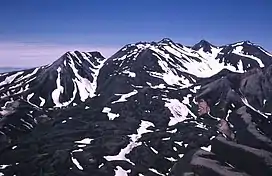
Black Peak is a highly eroded stratovolcano comprising a lava dome complex on the Alaska Peninsula of the U.S. state of Alaska.[3] Also called Purple Crater,[4] Black Volcano or Sopka Chornaia, the mountain is located within the Lake and Peninsula Borough.[2]
The latest eruption from Black Peak less than 4,000 years ago produced an explosive VEI-6 eruption that created a caldera. Ash flow tuffs and block and ash flow deposits from this explosive eruption traveled down the Ash Creek and Bluff Creek valleys that reach depths of 100 m (328 ft).
References
- ↑ Chignik C-3 quadrangle, Alaska (Map). 1:24000. 7.5 Minute Topographic. USGS.
- 1 2 "Black Peak". Geographic Names Information System. United States Geological Survey, United States Department of the Interior.
- ↑ "Black Peak". Global Volcanism Program. Smithsonian Institution.
- ↑ Moxham, R. M. (1952). Pumice deposits in the Alaska Peninsula-Cook Inlet region (Report). U.S. Geological Survey.
This article is issued from Wikipedia. The text is licensed under Creative Commons - Attribution - Sharealike. Additional terms may apply for the media files.