From May 18–21, 2013, a significant tornado outbreak took place across parts of the Midwestern United States and lower Great Plains. This event occurred just days after a deadly outbreak struck Texas and surrounding southern states on May 15. On May 16, a slow moving trough crossed the Rockies and traversed the western Great Plains. Initially, activity was limited to scattered severe storms; however, by May 18, the threat for organized severe thunderstorms and tornadoes greatly increased. A few tornadoes touched down that day in Kansas and Nebraska, including an EF4 tornado near Rozel, Kansas. Maintaining its slow eastward movement, the system produced another round of severe weather nearby. Activity significantly increased on May 19, with tornadoes confirmed in Oklahoma, Kansas, Iowa, Missouri, and Illinois. In Oklahoma, two strong tornadoes, one rated EF4, caused significant damage in rural areas of the eastern Oklahoma City metropolitan area; two people lost their lives in Shawnee. The most dramatic events unfolded on May 20 as a large EF5 tornado devastated parts of Moore, Oklahoma, with 24 people being killed. Thousands of structures were destroyed, with many being completely flattened. Several other tornadoes occurred during the day in areas further eastward, though the majority were weak and caused little damage.
The severe threat shifted towards damaging straight-line winds on May 21 as a large squall line developed across the southern states. Further north in Ontario, three tornadoes, including one that was rated EF2, touched down. Over the following five days, the system responsible for the outbreak moved very little across the Eastern United States. By May 24, it virtually stalled off the coast of New England, resulting in several days of heavy rain across the region. It later moved northeastward and was last noted by the Weather Prediction Center late on May 26 over southeastern Canada. During the storm's eleven-day trek across the United States, it produced 75 tornadoes, 4 of which were rated EF3 or higher. Over 1,000 reports of damaging winds were received by the Storm Prediction Center as well. The system's slow movement also resulted in record-breaking rains in North Dakota, New York, and Vermont. Additionally, during the overnight of May 25 – 26, unusually cold air behind the cyclone resulting in record-late snows across northern New England.
Confirmed tornadoes
| EFU | EF0 | EF1 | EF2 | EF3 | EF4 | EF5 | Total |
|---|---|---|---|---|---|---|---|
| 0 | 37 | 32 | 5 | 1 | 2 | 1 | 78 |
May 18 event
| EF# | Location | County / Parish | State | Start Coord. | Time (UTC) | Path length | Max width | Summary |
|---|---|---|---|---|---|---|---|---|
| EF0 | WSW of Cedar Bluff Reservoir | Trego | KS | 38°45′37″N 99°51′20″W / 38.7602°N 99.8556°W | 2227 – 2236 | 2.92 mi (4.70 km) | 100 yd (91 m) | A tornado tracked over open fields and caused no damage.[1] |
| EF0 | N of Broadwater | Morrill | NE | 41°43′49″N 102°51′00″W / 41.7303°N 102.85°W | 2258 – 2301 | 1 mi (1.6 km) | 50 yd (46 m) | A brief tornado caused no damage.[2] |
| EF0 | NNW of Brownell | Ness | KS | 38°40′38″N 99°44′43″W / 38.6771°N 99.7453°W | 2303 – 2305 | 0.31 mi (0.50 km) | 100 yd (91 m) | A brief multiple-vortex tornado caused no damage.[3] |
| EF1 | SSW of Ellis | Ellis | KS | 38°51′03″N 99°35′06″W / 38.8509°N 99.5849°W | 2309 – 2312 | 1.71 mi (2.75 km) | 50 yd (46 m) | Several trees and power poles were damaged.[4] |
| EF0 | NW of Antonino | Ellis | KS | 38°49′33″N 99°25′55″W / 38.8259°N 99.4319°W | 2337 – 2339 | 0.56 mi (0.90 km) | 50 yd (46 m) | A brief tornado caused no damage.[5] |
| EF4 | W of Rozel | Pawnee | KS | 38°08′34″N 99°28′14″W / 38.1429°N 99.4706°W | 0018 – 0047 | 7 mi (11 km) | 1,100 yd (1,000 m) | Five farm houses were damaged by this large, cone-shaped tornado, one of which had most of its roof and some of its exterior walls destroyed at the house (the other four sustained minor damage). An outbuilding was destroyed, another outbuilding suffered minor damage, and a large 1,000 US gallons (3,800 L) propane tank was ripped off of its concrete foundation and tossed 0.25 mi (400 m). Many trees and power lines were downed, seven irrigation pivots were flipped, and part of a road was scoured as well. The EF4 rating was confirmed based on Doppler on Wheels surface wind observations of 165 to 185 mph (266 to 298 km/h).[6] |
| EF1 | ENE of Sanford | Pawnee | KS | 38°12′04″N 99°16′36″W / 38.2011°N 99.2768°W | 0049 – 0101 | 4 mi (6.4 km) | 100 yd (91 m) | This tornado developed to east of the previous event and damaged trees and power poles.[7] |
| EF0 | SSE of Ash Valley | Pawnee | KS | 38°14′31″N 99°10′54″W / 38.242°N 99.1818°W | 0110 – 0113 | 2.06 mi (3.32 km) | 100 yd (91 m) | This was the third tornado associated with the supercell that spawned the EF4 Rozel storm; no damage occurred.[8] |
| EF1 | NW of Clay Center | Clay, Washington | KS | 39°29′10″N 97°16′41″W / 39.486°N 97.278°W | 0335 – 0345 | 6.99 mi (11.25 km) | 75 yd (69 m) | Irrigation pivots were overturned, trees were downed, and outbuildings were destroyed.[9] |
| EF0 | Southern Washington | Washington | KS | 39°48′40″N 97°03′22″W / 39.811°N 97.056°W | 0400 – 0402 | 0.34 mi (0.55 km) | 50 yd (46 m) | Several trees were downed and large tree limbs were torn. A barn also lost its roof.[10] |
May 19 event
| EF# | Location | County / Parish | State | Start Coord. | Time (UTC) | Path length | Max width | Summary |
|---|---|---|---|---|---|---|---|---|
| EF0 | SW of Viola | Sumner | KS | 37°27′01″N 97°40′11″W / 37.4504°N 97.6697°W | 2010–2012 | 0.57 mi (0.92 km) | 50 yd (46 m) | A brief tornado remained over open country, causing no damage.[11] |
| EF0 | E of Viola | Sedgwick | KS | 37°29′37″N 97°35′11″W / 37.4937°N 97.5864°W | 2019–2024 | 0.8 mi (1.3 km) | 50 yd (46 m) | A brief rope tornado moved over open country, causing no damage.[12] |
| EF2 | NNE of Clearwater | Sedgwick | KS | 37°34′47″N 97°30′22″W / 37.5797°N 97.5061°W | 2037 – 2048 | 4.61 mi (7.42 km) | 300 yd (270 m) | A silo was destroyed, a trailer was blown into outbuildings, and a brick home suffered roof damage. A 3,500 pounds (1,600 kg) horse trailer was rolled 220 yd (200 m), another trailer was rolled 50 to 75 yd (46 to 69 m), and two irrigation pivots were flipped over. A plank of wood was thrown through a car window and an outbuilding was moved off of its foundation. Several trees and power poles were downed as well. The Doppler on Wheels recorded peak winds of 155 miles per hour (249 km/h) at 230 feet (70 m) above ground level.[13] |
| EF0 | SW of Wellington | Sumner | KS | 37°08′N 97°29′W / 37.14°N 97.49°W | 2112–2113 | 0.42 mi (0.68 km) | 50 yd (46 m) | A trained spotter observed a brief tornado in an open field; no damage was reported.[14] |
| EF1 | Edmond | Oklahoma | OK | 35°37′26″N 97°28′52″W / 35.624°N 97.481°W | 2122 – 2130 | 4.5 mi (7.2 km) | 900 yd (820 m) | Twelve homes in the town were damaged, including three that sustained major damage. Nine transmission towers were also destroyed by the tornado and it was estimated that it would take a month to replace them.[15] |
| EF1 | SW of Arcadia | Oklahoma | OK | 35°39′12″N 97°21′44″W / 35.6534°N 97.3621°W | 2133 - 2134 | 0.54 mi (0.87 km) | 200 yd (180 m) | A power pole was damaged.[16] |
| EF0 | WSW of South Haven | Sumner | KS | 37°03′N 97°24′W / 37.05°N 97.40°W | 2139–2141 | 0.47 mi (0.76 km) | 50 yd (46 m) | A brief tornado was reported by a trained spotter; no damage occurred.[17] |
| EF0 | S of South Haven | Sumner | KS | 37°02′00″N 97°24′54″W / 37.0333°N 97.4151°W | 2140–2141 | 0.4 mi (0.64 km) | 50 yd (46 m) | A rope tornado was reported; no damage occurred.[18] |
| EF3 | NW of Luther to SE of Tryon | Oklahoma, Logan, Lincoln | OK | 35°41′35″N 97°13′55″W / 35.693°N 97.232°W | 2141 – 2224 | 20.84 mi (33.54 km) | 1,200 yd (1,100 m) | This large multiple-vortex wedge tornado destroyed an outbuilding and two mobile homes shortly after touching down. Along I-35, a hospital that was under-construction had windows blown out and its roof damaged. The tornado clipped the southeastern edge of Carney, damaging or destroying 40 homes and a few industrial buildings there. Power and water supply was knocked out to the town as well. Debris from Carney was reported to have fallen up to 55 mi (89 km) away in Hallett. Video of this tornado revealed extremely violent motions within the funnel, indicating that the tornado may have been stronger than EF3 intensity, but there were no damage indicators to confirm this. Four people were injured.[19] |
| EF1 | SE of Udall | Cowley | KS | 37°20′25″N 97°09′18″W / 37.3404°N 97.1549°W | 2146 – 2148 | 0.71 mi (1.14 km) | 50 yd (46 m) | A tornado that was reported by a spotter caused minor damage to a farmstead.[20] |
| EF1 | NE of Wolbach | Greeley | NE | 41°26′20″N 98°21′54″W / 41.439°N 98.365°W | 2151 – 2153 | 0.23 mi (0.37 km) | 25 yd (23 m) | A short-lived tornado destroyed a mobile home and shed. Several trees were downed as well.[21] |
| EF1 | E of Udall | Cowley | KS | 37°22′14″N 97°05′39″W / 37.3705°N 97.0941°W | 2155 – 2159 | 1.84 mi (2.96 km) | 60 yd (55 m) | Minor damage occurred at a farmstead.[22] |
| EF0 | SW of Ramona | Marion | KS | 38°35′N 97°05′W / 38.59°N 97.08°W | 2205–2207 | 0.46 mi (0.74 km) | 50 yd (46 m) | Law enforcement observed a brief tornado; no damage was reported.[23] |
| EF0 | N of Ramona | Dickinson | KS | 38°35′N 97°05′W / 38.59°N 97.08°W | 2217 | 0.1 mi (0.16 km) | 25 yd (23 m) | The Ramona volunteer police department reported a brief tornado touchdown; no damaged occurred.[24] |
| EF1 | SE of Emporia | Lyon | KS | 38°19′24″N 96°12′25″W / 38.3232°N 96.207°W | 2227 – 2237 | 9 mi (14 km) | 75 yd (69 m) | A home and an outbuilding were damaged just west of the Emporia Municipal Airport shortly after the tornado touched down. Sporadic tree damage occurred along the rest of the path.[25] |
| EF0 | N of Arkansas City | Cowley | KS | 37°05′40″N 97°03′22″W / 37.0944°N 97.056°W | 2259–2300 | 0.19 mi (0.31 km) | 50 yd (46 m) | A brief tornado moved over open country with no damage being reported.[26] |
| EF4 | E of Norman to ESE of McLoud | Cleveland, Pottawatomie | OK | 35°15′11″N 97°18′00″W / 35.2531°N 97.3001°W | 2300 – 2350 | 23 mi (37 km) | 1,500 yd (1,400 m) | 2 deaths – See section on this tornado – Ten people were injured.[27] |
| EF0 | Southwestern Adel | Dallas | IA | 41°35′16″N 94°04′00″W / 41.5878°N 94.0668°W | 2332 – 2335 | 2.08 mi (3.35 km) | 100 yd (91 m) | A weak tornado, which formed within a very broad circulation, produced a short, intermittent path before dissipating prior to reaching populated areas of Adel.[28] |
| EF0 | N of Bethel Acres | Pottawatomie | OK | 35°20′11″N 97°01′22″W / 35.3365°N 97.0228°W | 2340 - 2343 | 2 mi (3.2 km) | 30 yd (27 m) | RaXPol mobile radar data confirmed that an anticyclonic tornado, which was a satellite to the long-tracked Lake Thunderbird–Shawnee EF4 tornado, damaged trees.[29] |
| EF1 | ESE of Dallas Center | Dallas | IA | 41°39′56″N 93°54′26″W / 41.6656°N 93.9073°W | 2345 – 2348 | 1.43 mi (2.30 km) | 100 yd (91 m) | A house suffered significant structural damage and numerous trees were downed.[30] |
| EF0 | WNW of Shamrock | Creek | OK | 35°55′56″N 96°36′51″W / 35.9323°N 96.6143°W | 2347 - 2348 | 0.2 mi (0.32 km) | 50 yd (46 m) | A brief tornado caused no damage.[31] |
| EF2 | W of Prague | Pottawatomie, Lincoln | OK | 35°27′29″N 96°47′42″W / 35.458°N 96.795°W | 2359 – 0012 | 7.25 mi (11.67 km) | 450 yd (410 m) | A house was pushed off of its cinder block foundation and numerous sheds/outbuildings were either damaged or destroyed. Two more houses lost much of their roofs and exterior walls and a fourth house suffered roof, wall, and window damage. A fifth house sustained minor roof damage, an RV was rolled, and many trees were downed.[32] |
| EF1 | SSE of Slater to SSE of Huxley | Polk, Story | IA | 41°50′47″N 93°40′07″W / 41.8463°N 93.6687°W | 0007 – 0012 | 4.71 mi (7.58 km) | 150 yd (140 m) | An itermittent tornado removed a garage and part of the roof from a manufactured home.[33] |
| EF1 | NNE of Prague to NW of Welty | Lincoln, Okfuskee, Creek | OK | 35°31′56″N 96°39′14″W / 35.5323°N 96.6538°W | 0017 – 0040 | 14.42 mi (23.21 km) | 700 yd (640 m) | Barns and outbuildings were damaged and numerous trees were downed.[34] |
| EF0 | E of Argo Fay | Carroll | IL | 42°00′N 89°59′W / 42.00°N 89.99°W | 0102 | 0.1 mi (0.16 km) | 50 yd (46 m) | Emergency management reported a brief tornado; no damage was reported.[35] |
May 20 event
| EF# | Location | County / Parish | State | Start Coord. | Time (UTC) | Path length | Max width | Summary |
|---|---|---|---|---|---|---|---|---|
| EF1 | E of Carthage | Jasper | MO | 37°10′02″N 94°16′48″W / 37.1672°N 94.2801°W | 0506 – 0508 | 0.5 mi (0.80 km) | 100 yd (91 m) | A brief tornado downed numerous trees and power lines. Outbuildings were destroyed as well.[36] |
| EF1 | WNW of Lockwood | Dade | MO | 37°23′17″N 93°58′00″W / 37.3881°N 93.9668°W | 0523 – 0524 | 0.65 mi (1.05 km) | 100 yd (91 m) | A grocery store suffered roof damage, a carport was thrown, and several trees were uprooted.[37] |
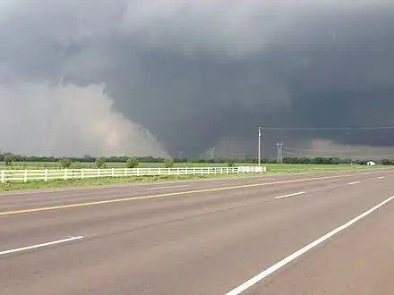
| EF5 | NW of Newcastle to E of Moore | McClain, Cleveland | OK | 35°17′02″N 97°37′41″W / 35.284°N 97.628°W | 1956 – 2035 | 13.85 mi (22.29 km) | 1,900 yd (1,700 m) | 24 deaths – See article on this tornado – 212 people were injured and there was one additional death due to natural causes that was indirectly related to the tornado. The tornado took a path similar to the May 3, 1999 Bridge Creek – Moore F5 tornado.[38] |
| EF0 | SSE of Marlow | Stephens | OK | 34°33′23″N 97°54′46″W / 34.5564°N 97.9129°W | 1958 – 2001 | 1 mi (1.6 km) | 30 yd (27 m) | Storm chasers reported a brief tornado; no known damage occurred.[39] |
| EF1 | Southern Marlow to W of Hope | Stephens | OK | 34°35′47″N 97°55′59″W / 34.5965°N 97.9331°W | 2007 – 2022 | 4 mi (6.4 km) | 200 yd (180 m) | A tornado was observed by several storm chasers and spotters. Trees and power lines suffered minor damage.[40] |
| EF1 | SSW of Avant to WNW of Vera | Osage, Washington | OK | 36°25′07″N 96°04′40″W / 36.4185°N 96.0778°W | 2051 – 2105 | 6.5 mi (10.5 km) | 500 yd (460 m) | A high-end EF1 tornado downed numerous trees, one of which fell onto the roof of a home.[41] |
| EF0 | SW of Dearing | Montgomery | KS | 37°02′N 95°44′W / 37.03°N 95.74°W | 2112–2114 | 0.54 mi (0.87 km) | 50 yd (46 m) | A brief tornado remained over open country and caused no damage.[42] |
| EF1 | ESE of Ramona | Washington | OK | 36°29′32″N 95°53′50″W / 36.4923°N 95.8971°W | 2121 – 2130 | 4.5 mi (7.2 km) | 400 yd (370 m) | A couple of homes were damaged and several trees were downed.[43] |
| EF1 | ENE of Ramona to NNW of Talala | Washington, Rogers | OK | 36°33′01″N 95°49′20″W / 36.5504°N 95.8223°W | 2133 – 2147 | 6 mi (9.7 km) | 500 yd (460 m) | The tornado remained mostly over open country, but one home had roof damage, windows blown out, and a chimney that was ripped from the roof. A nearby metal-frame barn had large doors blown out on both sides as well.[44][45] |
| EF0 | N of Lake Brownwood | Brown | TX | 31°52′N 99°01′W / 31.86°N 99.01°W | 2135 – 2149 | 1.17 mi (1.88 km) | 50 yd (46 m) | A weak tornado caused no damage.[46] |
| EF0 | NE of Meeker | Lincoln | OK | 35°33′41″N 96°48′53″W / 35.5614°N 96.8146°W | 2140 – 2142 | 1.21 mi (1.95 km) | 100 yd (91 m) | A brief tornado was reported; no damage was reported.[47] |
| EF0 | SW of Manter | Stanton | KS | 37°28′08″N 101°56′40″W / 37.4688°N 101.9445°W | 2150–2200 | 0.37 mi (0.60 km) | 50 yd (46 m) | A slow-moving landspout tornado caused no damage.[48] |
| EF0 | NE of Monte Vista | Alamosa | CO | 37°41′N 106°01′W / 37.68°N 106.01°W | 2253–2258 | 0.1 mi (0.16 km) | 75 yd (69 m) | A slow-moving landspout tornado remained in an open field; no damage was reported.[49] |
| EF1 | E of Knob Noster to N of Hughesville | Pettis | MO | 38°42′28″N 93°23′19″W / 38.7079°N 93.3886°W | 2157 – 2216 | 14.5 mi (23.3 km) | 200 yd (180 m) | This tornado touched down near Knob Noster downing trees, causing roof damage to one house, and causing wall, garage door, window, and roof damage to another house. The tornado moved northeast, downing several trees before reaching a farm, where several structures sustained roof damage and one lost its metal roof and siding. More trees were downed, and two farm equipment sheds were destroyed northeast of the farm. At another farm, parts of the roofs were removed from two buildings. The tornado continued northeast from the second farm and downed a few more trees before dissipating.[50] |
| EF0 | S of Manter | Stanton | KS | 37°30′20″N 101°52′48″W / 37.5055°N 101.88°W | 2205–2210 | 0.27 mi (0.43 km) | 50 yd (46 m) | A second landspout tornado formed after the previous one in Stanton County dissipated; no damage was reported.[51] |
| EF0 | S of Stockton | Cedar | MO | 37°39′14″N 93°49′48″W / 37.654°N 93.8301°W | 2237 – 2240 | 3.2 mi (5.1 km) | 100 yd (91 m) | A high-end EF0 tornado damaged a barn and several trees.[52] |
| EF1 | Blanket | Brown | TX | 31°50′N 98°47′W / 31.83°N 98.79°W | 2241 – 2255 | 3.65 mi (5.87 km) | 350 yd (320 m) | This tornado moved through Blanket and dissipated south-southeast of town. Two heavy air-conditioning units at Blanket High School were blown off of the roof. It caused roof damage to the gymnasium at the school as well as the nearby bus barn. Trees, power lines, steel fencing, and to tombstones at a cemetery were all knocked down. Some of the trees were oak trees that were more than 100 years old.[53] |
| EF0 | S of Ringgold | Montague | TX | 33°47′53″N 97°55′52″W / 33.798°N 97.931°W | 2241–2244 | 0.92 mi (1.48 km) | 50 yd (46 m) | A brief tornado was observed by trained spotters just south of Ringgold. It remained over open land, causing minimal damage.[54] |
| EF0 | NNE of Zephyr | Brown | TX | 31°44′N 98°47′W / 31.73°N 98.78°W | 2300 – 2303 | 0.2 mi (0.32 km) | 50 yd (46 m) | A brief tornado caused no damage.[55] |
| EF1 | NW of Lamar | Barton | MO | 37°31′13″N 94°25′25″W / 37.5204°N 94.4237°W | 2303 – 2305 | 6.81 mi (10.96 km) | 100 yd (91 m) | Trees were downed and outbuildings were damaged.[56] |
| EF2 | N of Fairland to NE of Wyandotte | Ottawa | OK | 36°48′46″N 94°50′46″W / 36.8129°N 94.8461°W | 2325 – 2340 | 10 mi (16 km) | 800 yd (730 m) | Several homes were damaged, a metal building was severely damaged, and many trees were downed. The tornado occurred simultaneously with the one below.[57] |
| EF1 | NW of Wyandotte, OK to SE of Seneca, MO | Ottawa (OK), Newton (MO) | OK, MO | 36°48′46″N 94°46′12″W / 36.8128°N 94.7701°W | 2332 – 2343 | 9.31 mi (14.98 km) | 600 yd (550 m) | This high-end EF1 tornado developed as a twin to the above tornado. Several houses, barns, and outbuildings were damaged. Several trees were downed as well.[58][59] |
| EF1 | ESE of Proctor | Adair | OK | 35°56′51″N 94°45′29″W / 35.9476°N 94.7581°W | 2332 – 2334 | 2 mi (3.2 km) | 150 yd (140 m) | Several trees were downed.[60] |
| EF1 | W of Christie | Adair | OK | 35°56′20″N 94°43′38″W / 35.939°N 94.7271°W | 2335 – 2337 | 2.5 mi (4.0 km) | 300 yd (270 m) | Trees were downed and a barn was damaged.[61] |
| EF1 | WSW of Christie, OK to N of Cincinnati, AR | Adair (OK), Washington (AR) | OK, AR | 35°58′54″N 94°36′50″W / 35.9817°N 94.614°W | 2340 – 2347 | 8 mi (13 km) | 500 yd (460 m) | Two barns were destroyed, a third barn was damaged, and numerous trees were downed.[62] |
| EF1 | N of Siloam Springs | Benton | AR | 36°12′00″N 94°34′08″W / 36.2001°N 94.5690°W | 2349 – 2354 | 2.9 mi (4.7 km) | 500 yd (460 m) | Several homes suffered minor damage and many trees were downed.[63] |
| EF1 | Lehigh | Coal | OK | 34°26′52″N 96°17′06″W / 34.4479°N 96.2849°W | 2349 – 2357 | 5.9 mi (9.5 km) | 250 yd (230 m) | Trees and outbuildings were damaged.[64] |
| EF0 | NNW of Collins | St. Clair | MO | 37°56′15″N 93°38′10″W / 37.9375°N 93.636°W | 2356 – 2357 | 0.48 mi (0.77 km) | 200 yd (180 m) | A brief tornado downed several trees.[65] |
| EF1 | SE of Prairie Creek | Benton | AR | 36°19′12″N 93°55′47″W / 36.3200°N 93.9296°W | 0024 – 0025 | 0.8 mi (1.3 km) | 270 yd (250 m) | A brief tornado embedded in a larger area of straight-line winds in the Beaver Lake area damaged one home and several boat docks. Many trees were downed as well.[66] |
| EF1 | WSW of Hannibal | Marion | MO | 39°41′38″N 91°26′55″W / 39.6938°N 91.4486°W | 0024 – 0026 | 1.16 mi (1.87 km) | 50 yd (46 m) | A farm building suffered roof damage and many trees were downed.[67] |
| EF0 | ENE of Priddy | Mills | TX | 31°40′37″N 98°29′06″W / 31.677°N 98.485°W | 0025–0027 | 1.08 mi (1.74 km) | 100 yd (91 m) | The Mills County Emergency Manager observed a tornado to the east-northeast of Priddy. It remained over open land, causing minimal damage.[68] |
| EF1 | NE of Shell Knob | Barry, Stone | MO | 36°37′40″N 93°35′04″W / 36.6279°N 93.5845°W | 0050 – 0052 | 1.42 mi (2.29 km) | 200 yd (180 m) | Several trees were downed.[69][70] |
| EF0 | N of Reeds Spring (1st tornado) | Stone | MO | 36°47′22″N 93°23′33″W / 36.7895°N 93.3925°W | 0105–0106 | 1.35 mi (2.17 km) | 100 yd (91 m) | A brief tornado downed several trees and tree limbs.[71] |
| EF1 | N of Reeds Spring (2nd tornado) | Stone | MO | 36°46′32″N 93°22′38″W / 36.7755°N 93.3772°W | 0105 – 0106 | 0.58 mi (0.93 km) | 100 yd (91 m) | Trees were downed along the path.[72] |
| EF0 | SW of Bokoshe | Le Flore | OK | 35°08′24″N 94°52′35″W / 35.1399°N 94.8763°W | 0133–0134 | 0.7 mi (1.1 km) | 260 yd (240 m) | Several trees were downed.[73] |
| EF1 | Cameron | Le Flore | OK | 35°04′25″N 94°35′20″W / 35.0737°N 94.5888°W | 0144 – 0155 | 8.5 mi (13.7 km) | 500 yd (460 m) | A home sustained minor roof damage and several trees were downed.[74] |
| EF0 | NW of Gravois Mills | Morgan | MO | 38°20′N 92°52′W / 38.33°N 92.87°W | 0146–0147 | 0.74 mi (1.19 km) | 100 yd (91 m) | Brief tornado uprooted trees and caused minor structural damage.[75] |
| EF2 | Mount Olive | Macoupin | IL | 39°04′19″N 89°43′35″W / 39.072°N 89.7264°W | 0314 – 0315 | 0.2 mi (0.32 km) | 75 yd (69 m) | A brief, but strong high-end EF2 tornado moved through the downtown portion of Mount Olive. The second story of a brick building was blown off and several homes, including a historic two-story home, and business had windows blown out and significant roof damage, some of which had their roofs completely ripped off. Three people sustained minor injuries.[76] |
May 21 event
| EF# | Location | County / Parish | State | Start Coord. | Time (UTC) | Path length | Max width | Summary |
|---|---|---|---|---|---|---|---|---|
| EF0 | E of Roachdale | Putnam | IN | 39°50′54″N 86°43′32″W / 39.8483°N 86.7255°W | 0629 – 0631 | 1.05 mi (1.69 km) | 100 yd (91 m) | A brief tornado damaged a barn and a shed, flipped an irrigation system, and downed several trees.[77] |
| EF0 | WNW of North Salem | Hendricks | IN | 39°52′24″N 86°40′00″W / 39.8734°N 86.6666°W | 0634 – 0635 | 0.13 mi (0.21 km) | 30 yd (27 m) | A brief tornado caused damage to a home and a barn and downed several trees.[78] |
| EF0 | S of Midland | Simcoe | ON | 1730 – ? | 0.35 mi (0.56 km) | 55 yd (50 m) | A brief tornado near the community of Elmvale caused minor roof damage to a barn and downed six trees.[79] | |
| EF0 | N of Barrie | Simcoe | ON | 1800 – ? | 2.8 mi (4.5 km) | 550 yd (500 m) | A tornado near the community of Dalston damaged a farm silo and downed 50 trees.[79] | |
| EF2 | Glenarm | City of Kawartha Lakes | ON | Unknown | Unknown | Unknown | A barn was destroyed, a home lost its roof, and several trees were downed as well.[80][81] | |
See also
Notes
References
- ↑ "Storm Events Database - Event Details | National Centers for Environmental Information". National Centers for Environmental Information. 2013. Retrieved February 3, 2023.
- ↑ "Storm Events Database - Event Details | National Centers for Environmental Information". National Centers for Environmental Information. 2013. Retrieved February 3, 2023.
- ↑ "Storm Events Database - Event Details | National Centers for Environmental Information". National Centers for Environmental Information. 2013. Retrieved February 3, 2023.
- ↑ "Storm Events Database - Event Details | National Centers for Environmental Information". National Centers for Environmental Information. 2013. Retrieved February 3, 2023.
- ↑ "Storm Events Database - Event Details | National Centers for Environmental Information". National Centers for Environmental Information. 2013. Retrieved February 3, 2023.
- ↑ "EF4 Tornado Impacts Locations Near Rozel Kansas". National Weather Service Office in Dodge City, Kansas. National Oceanic and Atmospheric Administration. May 23, 2013. Archived from the original on September 9, 2013. Retrieved May 25, 2013."Storm Events Database - Event Details | National Centers for Environmental Information". National Centers for Environmental Information. 2013. Retrieved February 3, 2023.
- ↑ "Storm Events Database - Event Details | National Centers for Environmental Information". National Centers for Environmental Information. 2013. Retrieved February 3, 2023.
- ↑ "Storm Events Database - Event Details | National Centers for Environmental Information". National Centers for Environmental Information. 2013. Retrieved February 3, 2023.
- ↑ "Storm Events Database - Event Details | National Centers for Environmental Information". National Centers for Environmental Information. 2013. Retrieved February 3, 2023."Storm Events Database - Event Details | National Centers for Environmental Information". National Centers for Environmental Information. 2013. Retrieved February 3, 2023.
- ↑ "Storm Events Database - Event Details | National Centers for Environmental Information". National Centers for Environmental Information. 2013. Retrieved February 3, 2023.
- ↑ National Weather Service in Wichita, Kansas (2013). [Kansas Event Report: EF0 Tornado] (Report). National Centers for Environmental Information. Retrieved February 4, 2023.
- ↑ National Weather Service in Wichita, Kansas (2013). [Kansas Event Report: EF0 Tornado] (Report). National Centers for Environmental Information. Retrieved February 4, 2023.
- ↑ National Weather Service in Wichita, Kansas (2013). [Kansas Event Report: EF2 Tornado] (Report). National Centers for Environmental Information. Retrieved February 4, 2023.
- ↑ National Weather Service in Wichita, Kansas (2013). [Kansas Event Report: EF0 Tornado] (Report). National Centers for Environmental Information. Retrieved February 4, 2023.
- ↑ National Weather Service in Norman, Oklahoma (2013). [Oklahoma Event Report: EF1 Tornado] (Report). National Centers for Environmental Information. Retrieved February 4, 2023.
- ↑ National Weather Service in Norman, Oklahoma (2013). [Oklahoma Event Report: EF1 Tornado] (Report). National Centers for Environmental Information. Retrieved February 4, 2023.
- ↑ National Weather Service in Wichita, Kansas (2013). [Kansas Event Report: EF0 Tornado] (Report). National Centers for Environmental Information. Retrieved February 4, 2023.
- ↑ National Weather Service in Wichita, Kansas (2013). [Kansas Event Report: EF0 Tornado] (Report). National Centers for Environmental Information. Retrieved February 4, 2023.
- ↑ "Violent tornadoes tear through central Oklahoma". KOKH-TV. May 19, 2013. Archived from the original on June 15, 2013. Retrieved May 27, 2013."Recovery Efforts in Carney After Tornado Destroys 40 Homes". KTUL. May 22, 2013. Retrieved May 27, 2013.Chris Day (May 20, 2013). "Carney without power, water after Sunday's tornado". Carney, Oklahoma: Stillwater NewsPress. Retrieved May 27, 2013."Carney Debris Falls In Hallett; Tornado Touches Down Near Prague". Carney, Oklahoma: NewsOn6. May 20, 2013. Retrieved May 20, 2013."Storm Events Database - Event Details | National Centers for Environmental Information". National Centers for Environmental Information. 2013. Retrieved February 3, 2023."Storm Events Database - Event Details | National Centers for Environmental Information". National Centers for Environmental Information. 2013. Retrieved February 3, 2023."Storm Events Database - Event Details | National Centers for Environmental Information". National Centers for Environmental Information. 2013. Retrieved February 3, 2023.
- ↑ National Weather Service in Wichita, Kansas (2013). [Kansas Event Report: EF0 Tornado] (Report). National Centers for Environmental Information. Retrieved February 4, 2023.
- ↑ National Weather Service in Hastings, Nebraska (2013). [Nebraska Event Report: EF1 Tornado] (Report). National Centers for Environmental Information. Retrieved February 4, 2023.
- ↑ National Weather Service in Wichita, Kansas (2013). [Kansas Event Report: EF1 Tornado] (Report). National Centers for Environmental Information. Retrieved February 4, 2023.
- ↑ National Weather Service in Wichita, Kansas (2013). [Kansas Event Report: EF0 Tornado] (Report). National Centers for Environmental Information. Retrieved February 4, 2023.
- ↑ National Weather Service in Topeka, Kansas (2013). [Kansas Event Report: EF0 Tornado] (Report). National Centers for Environmental Information. Retrieved February 4, 2023.
- ↑ National Weather Service in Topeka, Kansas (2013). [Kansas Event Report: EF1 Tornado] (Report). National Centers for Environmental Information. Retrieved February 4, 2023.
- ↑ National Weather Service in Wichita, Kansas (2013). [Kansas Event Report: EF0 Tornado] (Report). National Centers for Environmental Information. Retrieved February 4, 2023.
- ↑ National Weather Service in Norman, Oklahoma (2013). [Oklahoma Event Report: EF3 Tornado] (Report). National Centers for Environmental Information. Retrieved February 4, 2023.National Weather Service in Norman, Oklahoma (2013). [Oklahoma Event Report: EF4 Tornado] (Report). National Centers for Environmental Information. Retrieved February 4, 2023.
- ↑ National Weather Service in Des Moines, Iowa (2013). [Iowa Event Report: EF0 Tornado] (Report). National Centers for Environmental Information. Retrieved February 4, 2023.
- ↑ National Weather Service in Norman, Oklahoma (2013). [Oklahoma Event Report: EF0 Tornado] (Report). National Centers for Environmental Information. Retrieved February 4, 2023.
- ↑ National Weather Service in Des Moines, Iowa (2013). [Iowa Event Report: EF1 Tornado] (Report). National Centers for Environmental Information. Retrieved February 4, 2023.
- ↑ National Weather Service in Tulsa, Oklahoma (2013). [Oklahoma Event Report: EF0 Tornado] (Report). National Centers for Environmental Information. Retrieved February 4, 2023.
- ↑ National Weather Service in Norman, Oklahoma (2013). [Oklahoma Event Report: EF0 Tornado] (Report). National Centers for Environmental Information. Retrieved February 4, 2023.National Weather Service in Norman, Oklahoma (2013). [Oklahoma Event Report: EF2 Tornado] (Report). National Centers for Environmental Information. Retrieved February 4, 2023.
- ↑ National Weather Service in Des Moines, Iowa (2013). [Iowa Event Report: EF1 Tornado] (Report). National Centers for Environmental Information. Retrieved February 4, 2023.National Weather Service in Des Moines, Iowa (2013). [Iowa Event Report: EF0 Tornado] (Report). National Centers for Environmental Information. Retrieved February 4, 2023.
- ↑ National Weather Service in Norman, Oklahoma (2013). [Oklahoma Event Report: EF0 Tornado] (Report). National Centers for Environmental Information. Retrieved February 4, 2023.National Weather Service in Tulsa, Oklahoma (2013). [Oklahoma Event Report: EF1 Tornado] (Report). National Centers for Environmental Information. Retrieved February 4, 2023.National Weather Service in Tulsa, Oklahoma (2013). [Oklahoma Event Report: EF1 Tornado] (Report). National Centers for Environmental Information. Retrieved February 4, 2023.
- ↑ National Weather Service in Davenport, Iowa (2013). [Illinois Event Report: EF0 Tornado] (Report). National Centers for Environmental Information. Retrieved February 4, 2023.
- ↑ National Weather Service in Springfield, Missouri (2013). [Missouri Event Report: EF1 Tornado] (Report). National Centers for Environmental Information. Retrieved February 4, 2023.
- ↑ National Weather Service in Springfield, Missouri (2013). [Missouri Event Report: EF1 Tornado] (Report). National Centers for Environmental Information. Retrieved February 4, 2023.
- ↑ National Weather Service in Norman, Oklahoma (2013). [Oklahoma Event Report: EF4 Tornado] (Report). National Centers for Environmental Information. Retrieved February 4, 2023.National Weather Service in Norman, Oklahoma (2013). [Oklahoma Event Report: EF5 Tornado] (Report). National Centers for Environmental Information. Retrieved February 4, 2023.
- ↑ National Weather Service in Norman, Oklahoma (2013). [Oklahoma Event Report: EF0 Tornado] (Report). National Centers for Environmental Information. Retrieved February 4, 2023.
- ↑ National Weather Service in Norman, Oklahoma (2013). [Oklahoma Event Report: EF1 Tornado] (Report). National Centers for Environmental Information. Retrieved February 4, 2023.
- ↑ National Weather Service in Tulsa, Oklahoma (2013). [Oklahoma Event Report: EF1 Tornado] (Report). National Centers for Environmental Information. Retrieved February 4, 2023.National Weather Service in Tulsa, Oklahoma (2013). [Oklahoma Event Report: EF1 Tornado] (Report). National Centers for Environmental Information. Retrieved February 4, 2023.
- ↑ National Weather Service in Wichita, Kansas (2013). [Kansas Event Report: EF0 Tornado] (Report). National Centers for Environmental Information. Retrieved February 4, 2023.
- ↑ National Weather Service in Tulsa, Oklahoma (2013). [Oklahoma Event Report: EF1 Tornado] (Report). National Centers for Environmental Information. Retrieved February 4, 2023.
- ↑ National Weather Service in Tulsa, Oklahoma (2013). [Oklahoma Event Report: EF0 Tornado] (Report). National Centers for Environmental Information. Retrieved February 4, 2023.
- ↑ National Weather Service in Tulsa, Oklahoma (2013). [Oklahoma Event Report: EF1 Tornado] (Report). National Centers for Environmental Information. Retrieved February 4, 2023.
- ↑ National Weather Service in San Angelo, Texas (2013). [Texas Event Report: EF0 Tornado] (Report). National Centers for Environmental Information. Retrieved February 4, 2023.
- ↑ National Weather Service in Norman, Oklahoma (2013). [Oklahoma Event Report: EF0 Tornado] (Report). National Centers for Environmental Information. Retrieved February 4, 2023.
- ↑ National Weather Service in Dodge City, Kansas (2013). [Kansas Event Report: EF0 Tornado] (Report). National Centers for Environmental Information. Retrieved February 4, 2023.
- ↑ National Weather Service in Pueblo, Colorado (2013). [Colorado Event Report: EF0 Tornado] (Report). National Centers for Environmental Information. Retrieved February 4, 2023.
- ↑ National Weather Service in Kansas City, Missouri (2013). [Missouri Event Report: EF1 Tornado] (Report). National Centers for Environmental Information. Retrieved February 4, 2023.
- ↑ National Weather Service in Dodge City, Kansas (2013). [Kansas Event Report: EF0 Tornado] (Report). National Centers for Environmental Information. Retrieved February 4, 2023.
- ↑ National Weather Service in Springfield, Missouri (2013). [Missouri Event Report: EF0 Tornado] (Report). National Centers for Environmental Information. Retrieved February 4, 2023.
- ↑ National Weather Service in San Angelo, Texas (2013). [Texas Event Report: EF1 Tornado] (Report). National Centers for Environmental Information. Retrieved February 4, 2023.
- ↑ National Weather Service in Fort Worth, Texas (2013). [Texas Event Report: EF0 Tornado] (Report). National Centers for Environmental Information. Retrieved February 4, 2023.
- ↑ National Weather Service in San Angelo, Texas (2013). [Texas Event Report: EF0 Tornado] (Report). National Centers for Environmental Information. Retrieved February 4, 2023.
- ↑ National Weather Service in Springfield, Missouri (2013). [Missouri Event Report: EF1 Tornado] (Report). National Centers for Environmental Information. Retrieved February 4, 2023.
- ↑ National Weather Service in Tulsa, Oklahoma (2013). [Oklahoma Event Report: EF2 Tornado] (Report). National Centers for Environmental Information. Retrieved February 4, 2023.
- ↑ National Weather Service in Tulsa, Oklahoma (2013). [Oklahoma Event Report: EF1 Tornado] (Report). National Centers for Environmental Information. Retrieved February 4, 2023.
- ↑ National Weather Service in Springfield, Missouri (2013). [Missouri Event Report: EF1 Tornado] (Report). National Centers for Environmental Information. Retrieved February 4, 2023.
- ↑ National Weather Service in Tulsa, Oklahoma (2013). [Oklahoma Event Report: EF1 Tornado] (Report). National Centers for Environmental Information. Retrieved February 4, 2023.
- ↑ National Weather Service in Tulsa, Oklahoma (2013). [Oklahoma Event Report: EF1 Tornado] (Report). National Centers for Environmental Information. Retrieved February 4, 2023.
- ↑ National Weather Service in Tulsa, Oklahoma (2013). [Oklahoma Event Report: EF1 Tornado] (Report). National Centers for Environmental Information. Retrieved February 4, 2023.National Weather Service in Tulsa, Oklahoma (2013). [Arkansas Event Report: EF1 Tornado] (Report). National Centers for Environmental Information. Retrieved February 4, 2023.
- ↑ National Weather Service in Tulsa, Oklahoma (2013). [Arkansas Event Report: EF1 Tornado] (Report). National Centers for Environmental Information. Retrieved February 4, 2023.
- ↑ National Weather Service in Norman, Oklahoma (2013). [Oklahoma Event Report: EF1 Tornado] (Report). National Centers for Environmental Information. Retrieved February 4, 2023.
- ↑ National Weather Service in Springfield, Missouri (2013). [Missouri Event Report: EF0 Tornado] (Report). National Centers for Environmental Information. Retrieved February 4, 2023.
- ↑ National Weather Service in Tulsa, Oklahoma (2013). [Arkansas Event Report: EF1 Tornado] (Report). National Centers for Environmental Information. Retrieved February 4, 2023.
- ↑ National Weather Service in Springfield, Missouri (2013). [Missouri Event Report: EF1 Tornado] (Report). National Centers for Environmental Information. Retrieved February 4, 2023.
- ↑ National Weather Service in Fort Worth, Texas (2013). [Texas Event Report: EF0 Tornado] (Report). National Centers for Environmental Information. Retrieved February 4, 2023.
- ↑ National Weather Service in Springfield, Missouri (2013). [Missouri Event Report: EF1 Tornado] (Report). National Centers for Environmental Information. Retrieved February 4, 2023.
- ↑ National Weather Service in Springfield, Missouri (2013). [Missouri Event Report: EF1 Tornado] (Report). National Centers for Environmental Information. Retrieved February 4, 2023.
- ↑ National Weather Service in Springfield, Missouri (2013). [Missouri Event Report: EF0 Tornado] (Report). National Centers for Environmental Information. Retrieved February 4, 2023.
- ↑ National Weather Service in Springfield, Missouri (2013). [Missouri Event Report: EF0 Tornado] (Report). National Centers for Environmental Information. Retrieved February 4, 2023.
- ↑ National Weather Service in Tulsa, Oklahoma (2013). [Oklahoma Event Report: EF0 Tornado] (Report). National Centers for Environmental Information. Retrieved February 4, 2023.
- ↑ National Weather Service in Tulsa, Oklahoma (2013). [Oklahoma Event Report: EF1 Tornado] (Report). National Centers for Environmental Information. Retrieved February 4, 2023.
- ↑ National Weather Service in Springfield, Missouri (2013). [Missouri Event Report: EF0 Tornado] (Report). National Centers for Environmental Information. Retrieved February 4, 2023.
- ↑ National Weather Service in St. Louis, Missouri (2013). [Illinois Event Report: EF2 Tornado] (Report). National Centers for Environmental Information. Retrieved February 4, 2023.
- ↑ "Storm Events Database - Event Details | National Centers for Environmental Information". National Centers for Environmental Information. 2013. Retrieved February 3, 2023.
- ↑ "Storm Events Database - Event Details | National Centers for Environmental Information". National Centers for Environmental Information. 2013. Retrieved February 3, 2023.
- 1 2 Nicole Mortillaro (May 24, 2013). "Environment Canada confirms two more tornadoes in Ontario". Global News. Archived from the original on June 17, 2013. Retrieved May 25, 2013.Chris Kitching (May 25, 2013). "Two more tornadoes confirmed in Tuesday's storms". CP24. Archived from the original on June 18, 2022. Retrieved May 25, 2013.
- ↑ "Environment Canada confirms Ontario's second tornado of 2013". The Weather Network. May 23, 2013. Retrieved May 23, 2013.
- ↑ "Tornado touches down in Ontario town". Canadian Broadcasting Corporation. May 22, 2013. Retrieved May 23, 2013.