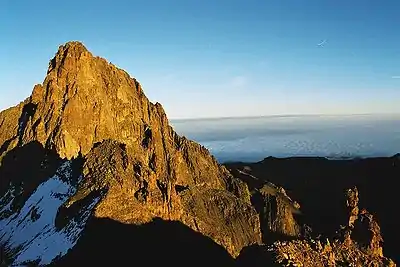
List of mountains in Kenya is a general list of mountains in Kenya with elevation. The highest mountain in Kenya, which is also the second-highest mountain in Africa, is Mount Kenya, standing at 5,199 metres (17,057 ft) tall.

Seven of Kenya's mountains, Mount Kenya, Mount Elgon, Mount Satima, Chepunyal Hills, Cherang'any Hills, Mount Kulal, and Mount Ng'iro, are among the ultra prominent peaks of Africa.

List

MountainHeight (m)RangeLocationRemarks
Mount Kenya5199Mount Kenya00°09′07″S 37°18′30″E / 0.15194°S 37.30833°E / -0.15194; 37.30833 (Mt Kenya (Batian) (5121 m))
Mount Elgon4302Mount Elgon01°05′59″N 34°34′26″E / 1.09972°N 34.57389°E / 1.09972; 34.57389 (Mt Elgon (Sudek) (4302 m))
Mount Satima4001Aberdare Range00°18′40″S 36°36′58″E / 0.31111°S 36.61611°E / -0.31111; 36.61611 (Oldoinyo Lesatima (4001 m))
Mount Kinangop3902Aberdare Range00°37′37″S 36°42′28″E / 0.62694°S 36.70778°E / -0.62694; 36.70778 (Mt Kinangop (3902 m))
Nakugen3530Cherang'any Hills01°15′06″N 35°27′02″E / 1.25167°N 35.45056°E / 1.25167; 35.45056 (Cherang'any Hills (3581 m))
Chemnirot3520Cherang'any Hills01°16′10″N 35°29′50″E / 1.26944°N 35.49722°E / 1.26944; 35.49722 (Chemnirot (Chemnirot Pk) (3530 m))
Kameleogon3500Cherang'any Hills01°16′10″N 35°29′50″E / 1.26944°N 35.49722°E / 1.26944; 35.49722 (Kameleogon (Kameleogon Pk) (3500 m))
Chebon3375Cherang'any Hills01°16′10″N 35°29′50″E / 1.26944°N 35.49722°E / 1.26944; 35.49722 (Chebon (Chebon Pk) (3375 m))
Chepkotet3370Cherang'any Hills01°16′10″N 35°29′50″E / 1.26944°N 35.49722°E / 1.26944; 35.49722 (Chepkotet (Chepkotet Pk) (3370 m))
Karelachngelat3350Cherang'any Hills01°16′10″N 35°29′50″E / 1.26944°N 35.49722°E / 1.26944; 35.49722 (Karelachngelat (Karelachngelat Pk) (3350 m))
Mount Kipipiri3349Aberdare Range00°43′53″S 36°54′52″E / 0.73139°S 36.91444°E / -0.73139; 36.91444 (Mt Kipipiri (3349 m))
Mount Mtelo333601°55′52″N 35°38′31″E / 1.93111°N 35.64194°E / 1.93111; 35.64194 (Mount Mtelo (3336 m))
Chepunyal Hills333401°37′00″N 35°15′00″E / 1.61667°N 35.25000°E / 1.61667; 35.25000 (Chepunyal Hills (3334 m))
Sodang3210Cherang'any Hills01°16′10″N 35°29′50″E / 1.26944°N 35.49722°E / 1.26944; 35.49722 (Sodang (Sodang Pk) (3210 m))
Mount Ng'iro284802°13′33″N 36°55′00″E / 2.22583°N 36.91667°E / 2.22583; 36.91667 (Mount Ng'iro (2848 m))
Mount Longonot277600°54′55″S 36°27′25″E / 0.91528°S 36.45694°E / -0.91528; 36.45694 (Mount Longonot (2776 m))
Ol Doinyo Orok254802°32′39″S 36°47′21″E / 2.54417°S 36.78917°E / -2.54417; 36.78917 (Mount Oldonyo Orok (2548 m))
Ngong hills246001°40′00″N 36°23′51″E / 1.66667°N 36.39750°E / 1.66667; 36.39750 (Ngong' hills (2460 m))
Enkamuka2308Ol Doinyo Orok02°32′34″S 36°46′22″E / 2.54278°S 36.77278°E / -2.54278; 36.77278 (Mount Mtelo (2308 m))
Menengai227800°22′51″S 36°09′53″E / 0.38083°S 36.16472°E / -0.38083; 36.16472 (Mount Menengai (2278 m))
Mount Kulal228501°43′45″N 36°55′24″E / 1.72917°N 36.92333°E / 1.72917; 36.92333 (Mount Kulal (2285 m))

See also

References

    This article is issued from Wikipedia. The text is licensed under Creative Commons - Attribution - Sharealike. Additional terms may apply for the media files.