This is a list of listed buildings in the parish of Tranent in East Lothian, Scotland.
List
| Name | Location | Date Listed | Grid Ref. [note 1] | Geo-coordinates | Notes | LB Number [note 2] | Image |
|---|---|---|---|---|---|---|---|
| 1-3 (Odd Numbers) Bridge Street, And 2 Church Street, Keepers Arms | 55°56′41″N 2°57′15″W / 55.944803°N 2.954257°W | Category C(S) | 42078 |  Upload Photo | |||
| 121 Church Street | 55°56′50″N 2°57′19″W / 55.947329°N 2.9552°W | Category C(S) | 42083 | Upload Photo | |||
| 110 Church Street With Retaining Walls | 55°56′49″N 2°57′20″W / 55.947003°N 2.955544°W | Category B | 42088 | Upload Photo | |||
| Edinburgh Road Bankpark House, With Lodge, Carriage House, Greenhouses, Garden Walls, Gatepiers And Gates | 55°56′48″N 2°57′50″W / 55.946721°N 2.964023°W | Category B | 42092 | Upload Photo | |||
| Edinburgh Road, 1-9 (Inclusive) Viewforth Terrace With Retaining Walls | 55°56′44″N 2°57′36″W / 55.945539°N 2.960023°W | Category B | 42093 | Upload Photo | |||
| 10 Fowler Street | 55°56′52″N 2°57′20″W / 55.947721°N 2.955594°W | Category B | 42095 | Upload Photo | |||
| St Germains House | 55°57′44″N 2°55′12″W / 55.962234°N 2.920022°W | Category B | 19075 | 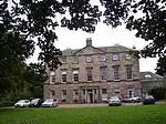
| |||
| Bankton House (Colonel Gardiner's House) With Retaining Walls | 55°57′09″N 2°58′13″W / 55.952395°N 2.97033°W | Category B | 17546 | 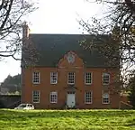
| |||
| Bankton House, Colonel Gardiner's Monument | 55°57′13″N 2°58′15″W / 55.953587°N 2.970696°W | Category B | 17547 | 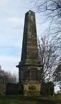
| |||
| 5 Bridge Street | 55°56′41″N 2°57′16″W / 55.944792°N 2.954465°W | Category C(S) | 42079 | Upload Photo | |||
| 205 Church Street, Seton Lodge With Retaining Walls, Railings And Gateways | 55°56′57″N 2°57′21″W / 55.949048°N 2.955947°W | Category B | 42084 | 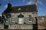
| |||
| 71 High Street | 55°56′37″N 2°57′07″W / 55.943732°N 2.952069°W | Category C(S) | 42097 | Upload Photo | |||
| Sanderson's Wynd, Tranent Infant School With Gates And Gatepiers, Retaining Walls And Shelters | 55°56′46″N 2°57′13″W / 55.946219°N 2.953523°W | Category B | 42099 | .jpg.webp)
| |||
| Elphinstone Tower With Gatepiers And Garden Walls | 55°55′08″N 2°58′39″W / 55.918752°N 2.97741°W | Category B | 19069 | Upload Photo | |||
| St Germains Coach House | 55°57′44″N 2°55′14″W / 55.96213°N 2.92066°W | Category B | 19072 | 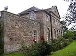
| |||
| Seton Collegiate Church, St Mary And Holy Cross, With Retaining Walls And Carved Panels | 55°57′56″N 2°56′01″W / 55.965456°N 2.933587°W | Category A | 19077 | Upload Photo | |||
| Seton West Mains Farmhouse With Garden Walls | 55°57′42″N 2°57′09″W / 55.961655°N 2.952461°W | Category C(S) | 19082 | Upload Photo | |||
| 12 Church Street | 55°56′43″N 2°57′16″W / 55.945151°N 2.954522°W | Category C(S) | 42087 | Upload Photo | |||
| 244 Church Street, The Manse Stables With Retaining Walls And Gatepiers | 55°56′58″N 2°57′24″W / 55.949358°N 2.956531°W | Category B | 42089 | Upload Photo | |||
| Seton Castle (Seton House), With Retaining Terrace And Walls | 55°57′55″N 2°56′06″W / 55.965212°N 2.934959°W | Category A | 19080 | 
| |||
| 8-10 (Even Numbers) Church Street | 55°56′42″N 2°57′16″W / 55.945053°N 2.954375°W | Category C(S) | 42086 | Upload Photo | |||
| High Street, Tranent War Memorial And Railings | 55°56′41″N 2°57′13″W / 55.944592°N 2.953547°W | Category B | 42098 | 
| |||
| Tranent Parish Church (Church Of Scotland) With Graveyard Walls, Gatepiers, Gates And Gravestones | 55°56′59″N 2°57′29″W / 55.949733°N 2.958029°W | Category B | 42100 | 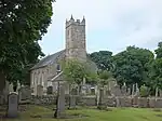
| |||
| Fa'side Castle (or Falside Castle), With Outbuilding And Retaining Walls | 55°55′40″N 2°59′51″W / 55.927828°N 2.997516°W | Category B | 19070 | .jpg.webp)
| |||
| St Joseph's School With Gates And Gatepiers | 55°57′17″N 2°57′12″W / 55.954737°N 2.95346°W | Category B | 19076 | Upload Photo | |||
| Tranent Mains Farmhouse | 55°57′04″N 2°56′54″W / 55.951119°N 2.948391°W | Category C(S) | 19083 | Upload Photo | |||
| Elphinstone, Main Street, War Memorial | 55°55′19″N 2°58′06″W / 55.921807°N 2.968349°W | Category C(S) | 17551 | 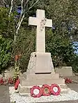
| |||
| St Germains, East Lodge With Outbuilding, Quadrant And Gatepiers | 55°57′52″N 2°55′22″W / 55.964468°N 2.922766°W | Category C(S) | 49601 | Upload Photo | |||
| 246 Church Street, With Balustrades And Retaining Walls | 55°56′59″N 2°57′24″W / 55.949716°N 2.9567°W | Category B | 42090 | Upload Photo | |||
| 252 Church Street | 55°57′00″N 2°57′23″W / 55.949916°N 2.956464°W | Category B | 42091 | Upload Photo | |||
| Seton Farmhouse With Retaining Walls | 55°57′51″N 2°56′28″W / 55.964177°N 2.941101°W | Category C(S) | 19078 | Upload Photo | |||
| Dovecot Brae, Tranent Dovecot | 55°57′00″N 2°57′29″W / 55.950119°N 2.958055°W | Category B | 17549 | 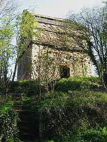
| |||
| Elphinstone, Main Street, Chapel | 55°55′16″N 2°58′14″W / 55.921189°N 2.97043°W | Category C(S) | 17550 | 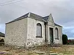
| |||
| 23 Bridge Street, Royal Bank Of Scotland | 55°56′41″N 2°57′18″W / 55.944797°N 2.954961°W | Category B | 42080 | Upload Photo | |||
| Church Street, House By Parish Church Hall | 55°56′49″N 2°57′17″W / 55.947027°N 2.954808°W | Category B | 42081 | Upload Photo | |||
| High Street, East Lothian Co-Operative Society Ltd | 55°56′41″N 2°57′14″W / 55.944859°N 2.953874°W | Category C(S) | 42096 | Upload Photo | |||
| St Germains Cottage | 55°57′43″N 2°55′13″W / 55.962052°N 2.920258°W | Category C(S) | 19073 | Upload Photo | |||
| Bankton House Garden House/Dovecot | 55°57′08″N 2°58′15″W / 55.952157°N 2.970933°W | Category C(S) | 17548 | 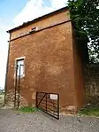
| |||
| Church Street, Parish Church Hall (Formerly Wishart Church) With Gates, Railings, Gatepiers And Retaining Walls | 55°56′49″N 2°57′16″W / 55.946939°N 2.954486°W | Category B | 42082 | Upload Photo | |||
| 4-6 (Even Numbers) Church Street | 55°56′42″N 2°57′16″W / 55.944945°N 2.954404°W | Category C(S) | 42085 | Upload Photo | |||
| 7 Edinburgh Road With Gates And Gatepiers | 55°56′45″N 2°57′40″W / 55.94573°N 2.960973°W | Category C(S) | 42094 | Upload Photo | |||
| St Clements Wells Dovecot | 55°55′52″N 3°00′13″W / 55.931202°N 3.003605°W | Category B | 19071 | 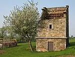
| |||
| St Germains Dovecot | 55°57′39″N 2°55′14″W / 55.960702°N 2.920546°W | Category B | 19074 | 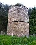
| |||
| Seton Gardens With Retaining Walls And Gatepiers | 55°57′49″N 2°56′00″W / 55.963734°N 2.933241°W | Category C(S) | 19079 | Upload Photo | |||
| Seton Mill Kiln And Granary | 55°58′02″N 2°56′10″W / 55.967262°N 2.936017°W | Category C(S) | 19081 | 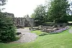 |
Key
The scheme for classifying buildings in Scotland is:
- Category A: "buildings of national or international importance, either architectural or historic; or fine, little-altered examples of some particular period, style or building type."[1]
- Category B: "buildings of regional or more than local importance; or major examples of some particular period, style or building type, which may have been altered."[1]
- Category C: "buildings of local importance; lesser examples of any period, style, or building type, as originally constructed or moderately altered; and simple traditional buildings which group well with other listed buildings."[1]
In March 2016 there were 47,288 listed buildings in Scotland. Of these, 8% were Category A, and 50% were Category B, with the remaining 42% being Category C.[2]
See also
Notes
- ↑ Sometimes known as OSGB36, the grid reference (where provided) is based on the British national grid reference system used by the Ordnance Survey.
• "Guide to National Grid". Ordnance Survey. Retrieved 12 December 2007.
• "Get-a-map". Ordnance Survey. Retrieved 17 December 2007. - ↑ Historic Environment Scotland assign a unique alphanumeric identifier to each designated site in Scotland, for listed buildings this always begins with "LB", for example "LB12345".
References
- All entries, addresses and coordinates are based on data from Historic Scotland. This data falls under the Open Government Licence
- 1 2 3 "What is Listing?". Historic Environment Scotland. Retrieved 29 May 2018.
- ↑ Scotland's Historic Environment Audit 2016 (PDF). Historic Environment Scotland and the Built Environment Forum Scotland. pp. 15–16. Retrieved 29 May 2018.
This article is issued from Wikipedia. The text is licensed under Creative Commons - Attribution - Sharealike. Additional terms may apply for the media files.