This is a list of listed buildings in the civil parish of Stoneykirk, in Dumfries and Galloway, Scotland.
List
| Name | Location | Date Listed | Grid Ref. [note 1] | Geo-coordinates | Notes | LB Number [note 2] | Image |
|---|---|---|---|---|---|---|---|
| Kildrochet House Including Gates And Gatepiers | 54°51′53″N 4°59′34″W / 54.864587°N 4.992762°W | Category B | 16712 |  Upload Photo | |||
| Windmill Plantation, Old Windmill | 54°49′42″N 4°58′05″W / 54.828209°N 4.96797°W | Category B | 16731 | Upload Photo | |||
| Clachanmore Gallery, Former School And Schoolhouse, Including Boundary Walls, Gatepiers, Gates And Ancillary Structures | 54°46′43″N 4°58′54″W / 54.778504°N 4.981746°W | Category C(S) | 16738 | Upload Photo | |||
| Ardwell, Ardwell House, Walled Garden Including Gardener's Cottage And Owl Statue | 54°46′00″N 4°57′06″W / 54.766571°N 4.951729°W | Category C(S) | 46697 | Upload Photo | |||
| Ardwell, Bowling Hall, Ivy And Shore Cottages Including Boundary Walls And Gates | 54°46′14″N 4°56′27″W / 54.770555°N 4.940948°W | Category C(S) | 46698 | Upload Photo | |||
| Stoneykirk Parish Church Graveyard Including Boundary Walls, Gatepiers And Gates | 54°50′14″N 4°58′39″W / 54.837289°N 4.977515°W | Category B | 16729 | Upload Photo | |||
| Kirkmabreck Farmhouse Including Farmhouse, Cottage, Steading, Boundary Walls And Gate | 54°47′28″N 4°57′30″W / 54.791042°N 4.958399°W | Category B | 16732 | Upload Photo | |||
| Drumbreddan Including Walled Garden, Steading, Farm Cottage, Boundary Walls And Gatepiers | 54°45′17″N 4°58′39″W / 54.754692°N 4.97757°W | Category B | 16737 | Upload Photo | |||
| Balgreggan, Walled Garden To Former Balgreggan House | 54°48′34″N 4°58′21″W / 54.809579°N 4.97244°W | Category C(S) | 46699 | Upload Photo | |||
| Balgreggan, Kennels And Barn To Former Balgreggan House, Including Boundary Walls And Gatepiers | 54°48′36″N 4°58′36″W / 54.809917°N 4.976636°W | Category C(S) | 46700 | Upload Photo | |||
| Ringuinea Moss | 54°47′06″N 4°59′30″W / 54.785087°N 4.991534°W | Category C(S) | 46704 | Upload Photo | |||
| Garthland Mains Including Farmhouse, Steading, Farm Cottage, Bridge, Tower, Boundary Walls And Gatepiers | 54°51′25″N 4°59′53″W / 54.85706°N 4.997939°W | Category B | 16714 | Upload Photo | |||
| Mains Of Caldons Farmhouse | 54°50′29″N 4°59′21″W / 54.841515°N 4.989199°W | Category C(S) | 46703 | Upload Photo | |||
| Ardwell, Ardwell Mains | 54°46′15″N 4°57′04″W / 54.770896°N 4.950987°W | Category C(S) | 16735 | Upload Photo | |||
| Ardwell, Ardwell House, East Lodge Including Boundary Walls, Gatepiers And Gate | 54°46′25″N 4°56′29″W / 54.77359°N 4.941479°W | Category C(S) | 46696 | Upload Photo | |||
| Ardwell, Ardwell House Including Lamp Standards, Gatepiers, Gate, Sundial And Owl Statue | 54°46′07″N 4°57′06″W / 54.768488°N 4.951651°W | Category B | 16733 | Upload Photo | |||
| Ardwell, Ardwell Church (Church Of Scotland) Including Boundary Walls, Gatepiers And Gates | 54°46′12″N 4°57′16″W / 54.770054°N 4.954549°W | Category B | 16734 | Upload Photo | |||
| Cairnhandy Farmhouse, Steading And Cottage, Including Boundary Walls | 54°45′59″N 4°57′58″W / 54.76625°N 4.965995°W | Category C(S) | 16736 | Upload Photo | |||
| Ardwell, Ardwell House, Boundary Walls, Gates And Gatepiers | 54°46′11″N 4°57′01″W / 54.769744°N 4.950265°W | Category C(S) | 46695 | Upload Photo | |||
| Lake Cottage Including Boundary Walls, Gatepiers And Outhouse | 54°47′48″N 4°57′43″W / 54.796677°N 4.961814°W | Category C(S) | 46702 | Upload Photo | |||
| Gruesey, Former United Free Manse, Including Boundary Walls And Gatepiers | 54°47′50″N 4°57′44″W / 54.797145°N 4.962175°W | Category B | 16717 | Upload Photo | |||
| Ardwell, Ardwell Mill | 54°47′45″N 4°57′17″W / 54.79593°N 4.954835°W | Category C(S) | 16718 | Upload Photo | |||
| East Cairnwell Including Farmhouse, Steading, Boundary Walls, Gates And Gatepiers | 54°47′52″N 4°58′10″W / 54.797803°N 4.969428°W | Category C(S) | 46701 | Upload Photo | |||
| Stoneykirk Parish Church (Church Of Scotland) And Railings | 54°50′14″N 4°58′37″W / 54.837264°N 4.977077°W | Category B | 16728 | Upload Photo | |||
| Kirkmadrine Church Including Graveyard, Mctaggart Memorial, Boundary Walls, Gatepiers And Gates | 54°47′37″N 4°59′16″W / 54.793539°N 4.987833°W | Category A | 16739 | 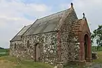 |
Key
The scheme for classifying buildings in Scotland is:
- Category A: "buildings of national or international importance, either architectural or historic; or fine, little-altered examples of some particular period, style or building type."[1]
- Category B: "buildings of regional or more than local importance; or major examples of some particular period, style or building type, which may have been altered."[1]
- Category C: "buildings of local importance; lesser examples of any period, style, or building type, as originally constructed or moderately altered; and simple traditional buildings which group well with other listed buildings."[1]
In March 2016 there were 47,288 listed buildings in Scotland. Of these, 8% were Category A, and 50% were Category B, with the remaining 42% being Category C.[2]
Notes
- ↑ Sometimes known as OSGB36, the grid reference (where provided) is based on the British national grid reference system used by the Ordnance Survey.
• "Guide to National Grid". Ordnance Survey. Retrieved 12 December 2007.
• "Get-a-map". Ordnance Survey. Retrieved 17 December 2007. - ↑ Historic Environment Scotland assign a unique alphanumeric identifier to each designated site in Scotland, for listed buildings this always begins with "LB", for example "LB12345".
References
- All entries, addresses and coordinates are based on data from Historic Scotland. This data falls under the Open Government Licence
- 1 2 3 "What is Listing?". Historic Environment Scotland. Retrieved 29 May 2018.
- ↑ Scotland's Historic Environment Audit 2016 (PDF). Historic Environment Scotland and the Built Environment Forum Scotland. pp. 15–16. Retrieved 29 May 2018.
This article is issued from Wikipedia. The text is licensed under Creative Commons - Attribution - Sharealike. Additional terms may apply for the media files.