This is a list of listed buildings in the parish of Prestonpans in East Lothian, Scotland.
List
| Name | Location | Date Listed | Grid Ref. [note 1] | Geo-coordinates | Notes | LB Number [note 2] | Image |
|---|---|---|---|---|---|---|---|
| High Street, War Memorial | 55°57′35″N 2°59′04″W / 55.959641°N 2.984559°W | Category B | 43946 | 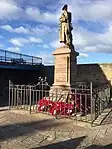
| |||
| 228 High Street (Walford) With Garden Walls And N Gateway | 55°57′31″N 2°59′20″W / 55.95851°N 2.988935°W | Category C(S) | 40323 |  Upload Photo | |||
| Preston, Preston Tower, Walls And Gatepiers | 55°57′21″N 2°58′39″W / 55.955699°N 2.97754°W | Category B | 17532 | 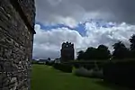
| |||
| Preston, Preston Road, Nursery Cottage, Including Boundary Wall And Gate | 55°57′18″N 2°58′38″W / 55.955125°N 2.977333°W | Category C(S) | 47015 | Upload Photo | |||
| Harlaw Hill House, With Stables And West Boundary Wall | 55°57′38″N 2°58′47″W / 55.960461°N 2.979774°W | Category A | 40322 | Upload Photo | |||
| Preston, Northfield House Dovecot | 55°57′14″N 2°58′43″W / 55.953973°N 2.978746°W | Category A | 17528 | 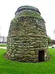
| |||
| Preston, Hamilton House, Including Boundary Walls, Doorway, Gatepiers, Gate And Railings | 55°57′18″N 2°58′44″W / 55.954979°N 2.978851°W | Category A | 17529 | 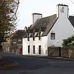
| |||
| 147-155 (Odd Nos) High Street | 55°57′33″N 2°59′07″W / 55.959034°N 2.985232°W | Category C(S) | 43947 | Upload Photo | |||
| Rock Cottage | 55°57′37″N 2°59′01″W / 55.960286°N 2.983742°W | Category C(S) | 43949 | Upload Photo | |||
| Prestongrange Colliery, Pump House And Pump | 55°57′07″N 3°00′18″W / 55.952047°N 3.004865°W | Category A | 17534 | Upload Photo | |||
| Prestongrange Colliery, Old Generating House | 55°57′07″N 3°00′17″W / 55.952039°N 3.00464°W | Category B | 17535 | Upload Photo | |||
| Prestongrange House | 55°57′09″N 2°59′47″W / 55.952367°N 2.996417°W | Category A | 17537 | 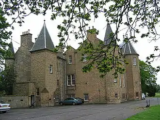
| |||
| Preston, Preston Road, Dovecot House, Including Boundary Wall | 55°57′17″N 2°58′44″W / 55.954591°N 2.978953°W | Category C(S) | 47014 | 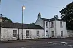
| |||
| Prestongrange House, Boundary Walls | 55°57′12″N 2°59′34″W / 55.953358°N 2.992695°W | Category B | 47021 | Upload Photo | |||
| Prestongrange House, East Lodge, And Gate Arch | 55°57′14″N 2°59′36″W / 55.953945°N 2.993431°W | Category C(S) | 47022 | Upload Photo | |||
| East Loan, Winfields With Boundary Walls And Gateways | 55°57′34″N 2°58′47″W / 55.959554°N 2.979783°W | Category B | 43944 | Upload Photo | |||
| Kirk Street, Prestongrange Church, Church Of Scotland | 55°57′36″N 2°58′53″W / 55.960124°N 2.981512°W | Category A | 40320 | 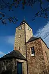
| |||
| Preston, Preston Tower | 55°57′21″N 2°58′41″W / 55.955712°N 2.978101°W | Category A | 17530 | 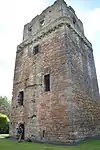
| |||
| Preston, Preston Cross | 55°57′20″N 2°58′34″W / 55.955558°N 2.976015°W | Category A | 17533 | 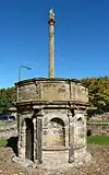
| |||
| Prestongrange House, North Lodge (Burn's Yard), Including Boundary Walls | 55°57′15″N 2°59′57″W / 55.954277°N 2.999141°W | Category C(S) | 17538 | Upload Photo | |||
| Drummore House Boundary Wall And Gatepiers To East Lodge Entrance | 55°56′57″N 3°00′24″W / 55.949246°N 3.006714°W | Category C(S) | 47012 | Upload Photo | |||
| West Loan, Public Library With Gatepiers, Gates And Walls | 55°57′31″N 2°58′57″W / 55.95866°N 2.982548°W | Category B | 43951 | Upload Photo | |||
| High Street, Old West Burial Ground | 55°57′29″N 2°59′16″W / 55.958134°N 2.98766°W | Category B | 40325 | 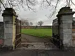
| |||
| Drummore House, Including Boundary Wall, And Well | 55°56′53″N 3°00′43″W / 55.947935°N 3.012044°W | Category B | 17552 | Upload Photo | |||
| Preston, Northfield House, Including Boundary Walls, Gates, Gatepiers And Corner Bartizan | 55°57′16″N 2°58′47″W / 55.954414°N 2.979846°W | Category A | 17560 | 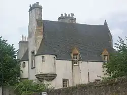
| |||
| Prestongrange House, South Lodge And Gate Arch | 55°56′59″N 2°59′43″W / 55.949726°N 2.995244°W | Category C(S) | 47023 | Upload Photo | |||
| East Loan, Rose Cottage With Boundary Wall | 55°57′36″N 2°58′46″W / 55.95997°N 2.979426°W | Category C(S) | 43943 | 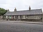
| |||
| West Loan, Grange Church, St Andrews Episcopal Church With Boundary Walls | 55°57′31″N 2°59′00″W / 55.958555°N 2.98333°W | Category C(S) | 43950 | Upload Photo | |||
| West Loan, Former Grange Manse With Gatepiers Gate And Boundary Walls | 55°57′24″N 2°58′49″W / 55.956548°N 2.980348°W | Category B | 40321 | Upload Photo | |||
| 227 High Street, The Gothenburg (Formerly Forth Tavern) | 55°57′27″N 2°59′26″W / 55.95749°N 2.990639°W | Category B | 40324 | 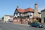
| |||
| Preston, Preston Road, Athelstane Lodge, Including Ancillary Structures And Boundary Walls | 55°57′18″N 2°58′35″W / 55.955096°N 2.9765°W | Category B | 19660 | Upload Photo | |||
| Prestongrange Colliery, Hoffman Kiln | 55°57′04″N 3°00′32″W / 55.951161°N 3.008765°W | Category B | 47020 | Upload Photo | |||
| High Street, Town Hall | 55°57′32″N 2°59′08″W / 55.958888°N 2.985517°W | Category C(S) | 43945 | .jpg.webp)
| |||
| Kirk Wynd, Thomas Alexander's Monument | 55°57′37″N 2°58′56″W / 55.960262°N 2.982236°W | Category C(S) | 43948 | 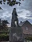
| |||
| Preston, Station Road, Preston Lodge, Including Boundary Walls And Gatepeirs | 55°57′17″N 2°58′39″W / 55.954836°N 2.977566°W | Category B | 40326 | Upload Photo | |||
| Preston, Preston Tower Dovecot | 55°57′24″N 2°58′43″W / 55.956545°N 2.97849°W | Category B | 17531 | 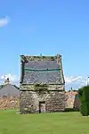
| |||
| Dolphingstone Dovecot | 55°56′38″N 2°59′29″W / 55.943853°N 2.991427°W | Category A | 17553 | 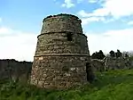
| |||
| Preston, Polwarth Playing Field Pavilion | 55°57′19″N 2°58′29″W / 55.955363°N 2.974617°W | Category C(S) | 47013 | Upload Photo |
Key
The scheme for classifying buildings in Scotland is:
- Category A: "buildings of national or international importance, either architectural or historic; or fine, little-altered examples of some particular period, style or building type."[1]
- Category B: "buildings of regional or more than local importance; or major examples of some particular period, style or building type, which may have been altered."[1]
- Category C: "buildings of local importance; lesser examples of any period, style, or building type, as originally constructed or moderately altered; and simple traditional buildings which group well with other listed buildings."[1]
In March 2016 there were 47,288 listed buildings in Scotland. Of these, 8% were Category A, and 50% were Category B, with the remaining 42% being Category C.[2]
See also
Notes
- ↑ Sometimes known as OSGB36, the grid reference (where provided) is based on the British national grid reference system used by the Ordnance Survey.
• "Guide to National Grid". Ordnance Survey. Retrieved 12 December 2007.
• "Get-a-map". Ordnance Survey. Retrieved 17 December 2007. - ↑ Historic Environment Scotland assign a unique alphanumeric identifier to each designated site in Scotland, for listed buildings this always begins with "LB", for example "LB12345".
References
- All entries, addresses and coordinates are based on data from Historic Scotland. This data falls under the Open Government Licence
- 1 2 3 "What is Listing?". Historic Environment Scotland. Retrieved 29 May 2018.
- ↑ Scotland's Historic Environment Audit 2016 (PDF). Historic Environment Scotland and the Built Environment Forum Scotland. pp. 15–16. Retrieved 29 May 2018.
This article is issued from Wikipedia. The text is licensed under Creative Commons - Attribution - Sharealike. Additional terms may apply for the media files.