This is a list of listed buildings in the parish of Glencorse in Midlothian, Scotland.
List
| Name | Location | Date Listed | Grid Ref. [note 1] | Geo-coordinates | Notes | LB Number [note 2] | Image |
|---|---|---|---|---|---|---|---|
| Woodhoouselee Policies, Burial Ground, Fraser Tytler Memorial | 55°51′58″N 3°13′26″W / 55.866195°N 3.223817°W | Category C(S) | 13510 |  Upload Photo | |||
| The Bush Policies, Gatepiers And Screen Walls | 55°51′43″N 3°12′15″W / 55.862004°N 3.20416°W | Category C(S) | 7463 | Upload Photo | |||
| Loganbank House, Loganbank And Loganlea (All Formerly Loganbank House) | 55°51′13″N 3°12′15″W / 55.853736°N 3.204272°W | Category B | 7466 | Upload Photo | |||
| Woodhouselee Policies, Former Stables | 55°52′05″N 3°13′04″W / 55.867936°N 3.21764°W | Category B | 13512 | Upload Photo | |||
| Glencorse, Old Glencorse Kirk | 55°51′17″N 3°12′26″W / 55.854605°N 3.207318°W | Category A | 7454 | .jpg.webp)
| |||
| Belwood House, Including North Wing And South Wing | 55°50′51″N 3°13′32″W / 55.847396°N 3.225686°W | Category B | 7460 | Upload Photo | |||
| The Bush House Including Stables, Laundry House, Boundary Walls, Gatepiers And Gates | 55°51′33″N 3°12′25″W / 55.859262°N 3.207063°W | Category A | 7462 | 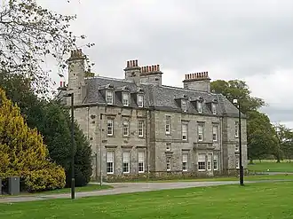
| |||
| The Bush Policies, Former Gardener's House | 55°51′37″N 3°12′29″W / 55.860287°N 3.207926°W | Category B | 47744 | Upload Photo | |||
| Old Glencorse Kirk, Watch House Kirkyard And Boundary Walls | 55°51′17″N 3°12′28″W / 55.854717°N 3.207753°W | Category C(S) | 47754 | Upload Photo | |||
| Glencorse Parish Church | 55°51′03″N 3°12′17″W / 55.850837°N 3.204821°W | Category A | 7456 | 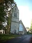
| |||
| Gillieknowe (Former Glencorse House Stables) Including Gatepiers, Gates, Quadrant Walls And Walled Garden | 55°51′21″N 3°12′40″W / 55.855763°N 3.211012°W | Category C(S) | 7457 | Upload Photo | |||
| Glencorse Barracks, The Keep (Former Quartermaster's Store And Armoury) | 55°50′42″N 3°12′09″W / 55.845019°N 3.202533°W | Category B | 7458 | Upload Photo | |||
| Aaron House Nursing And Residential Care Home (Former Beeslack House) | 55°50′23″N 3°12′25″W / 55.839728°N 3.207001°W | Category B | 7459 | Upload Photo | |||
| Glencorse Barracks, Clock Tower | 55°50′43″N 3°12′12″W / 55.845253°N 3.203355°W | Category A | 44614 | Upload Photo | |||
| Old Woodhouselee Tunnel | 55°50′31″N 3°11′24″W / 55.841852°N 3.189963°W | Category C(S) | 7465 | Upload Photo | |||
| Beeslack House, Lodge | 55°50′27″N 3°12′45″W / 55.840734°N 3.212509°W | Category C(S) | 47743 | Upload Photo | |||
| Glencorse Parish Church, War Memorial | 55°51′04″N 3°12′17″W / 55.850974°N 3.204634°W | Category C(S) | 47753 | 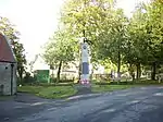
| |||
| Glencorse House, South Lodge, Boundary Walls, Gatepiers And Gates | 55°51′16″N 3°12′29″W / 55.854436°N 3.208016°W | Category B | 7455 | Upload Photo | |||
| Old Woodhouselee Railway Viaduct Over River North Esk | 55°50′31″N 3°11′10″W / 55.842017°N 3.185992°W | Category B | 7464 | Upload Photo | |||
| Glencorse Barracks, Chapel, Terrace And Stores | 55°50′43″N 3°12′10″W / 55.84525°N 3.202764°W | Category B | 44616 | Upload Photo | |||
| Glencorse Barracks, Barrack Block | 55°50′43″N 3°12′08″W / 55.845273°N 3.202285°W | Category B | 44615 | Upload Photo | |||
| Penicuick, Bellwood Road, Martyr's Cross House | 55°50′55″N 3°13′53″W / 55.848515°N 3.231519°W | Category B | 7461 | Upload Photo | |||
| Glencorse Barracks, Memorial Lodges, Gates, Gatepiers And Boundary Walls | 55°50′44″N 3°12′15″W / 55.845532°N 3.204226°W | Category B | 44617 | 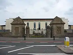
| |||
| Rullion Green, The Martyr's Tomb | 55°50′52″N 3°14′37″W / 55.847756°N 3.243586°W | Category B | 13650 | 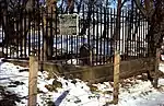
| |||
| Hillend Farmhouse And Steading | 55°53′11″N 3°11′53″W / 55.886352°N 3.198008°W | Category B | 13511 | Upload Photo | |||
| Woodhouselee Policies, Archway | 55°52′01″N 3°13′14″W / 55.86691°N 3.22058°W | Category B | 13513 | Upload Photo |
Key
The scheme for classifying buildings in Scotland is:
- Category A: "buildings of national or international importance, either architectural or historic; or fine, little-altered examples of some particular period, style or building type."[1]
- Category B: "buildings of regional or more than local importance; or major examples of some particular period, style or building type, which may have been altered."[1]
- Category C: "buildings of local importance; lesser examples of any period, style, or building type, as originally constructed or moderately altered; and simple traditional buildings which group well with other listed buildings."[1]
In March 2016 there were 47,288 listed buildings in Scotland. Of these, 8% were Category A, and 50% were Category B, with the remaining 42% being Category C.[2]
See also
Notes
- ↑ Sometimes known as OSGB36, the grid reference (where provided) is based on the British national grid reference system used by the Ordnance Survey.
• "Guide to National Grid". Ordnance Survey. Retrieved 12 December 2007.
• "Get-a-map". Ordnance Survey. Retrieved 17 December 2007. - ↑ Historic Environment Scotland assign a unique alphanumeric identifier to each designated site in Scotland, for listed buildings this always begins with "LB", for example "LB12345".
References
- All entries, addresses and coordinates are based on data from Historic Scotland. This data falls under the Open Government Licence
- 1 2 3 "What is Listing?". Historic Environment Scotland. Retrieved 29 May 2018.
- ↑ Scotland's Historic Environment Audit 2016 (PDF). Historic Environment Scotland and the Built Environment Forum Scotland. pp. 15–16. Retrieved 29 May 2018.
This article is issued from Wikipedia. The text is licensed under Creative Commons - Attribution - Sharealike. Additional terms may apply for the media files.