This is a list of listed buildings in Glasgow, Scotland.
List
| Name | Location | Date Listed | Grid Ref. [note 1] | Geo-coordinates | Notes | LB Number [note 2] | Image |
|---|---|---|---|---|---|---|---|
| 6 Spencer Street, Temple Primary School With Boundary Walls, Gates And Railings | 55°53′41″N 4°19′32″W / 55.894833°N 4.325675°W | Category C(S) | 43039 | 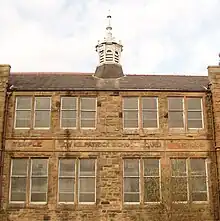
| |||
| 147-149 (Odd Nos) Newlands Road, Weir Pumps Ltd Cathcart Works, Offices And Amenity Building | 55°49′06″N 4°15′57″W / 55.818416°N 4.265736°W | Category B | 33947 |  Upload Photo | |||
| 1110 Pollokshaws Road, 4 Moss-Side Road, TSB Bank | 55°49′51″N 4°16′51″W / 55.830736°N 4.280904°W | Category B | 33955 | Upload Photo | |||
| Pollokshaws Road, Pollockshaws West Station Including Embankment Wall To Street | 55°49′26″N 4°18′06″W / 55.823879°N 4.301625°W | Category B | 33959 | 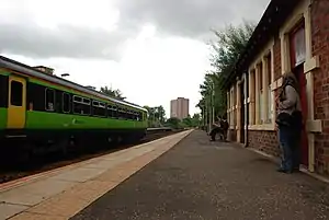
| |||
| Shawhill Road, War Memorial At St Mary Immaculate RC Church | 55°49′33″N 4°17′33″W / 55.825836°N 4.292591°W | Category B | 33966 | 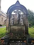
| |||
| 1, 13 Circus Drive, Golfhill Public School Including Janitor's Lodge, Gates And Railings | 55°51′45″N 4°13′34″W / 55.862457°N 4.226221°W | Category B | 33892 | Upload Photo | |||
| 116-120A (Even Nos) Duke Street, And 214 Hunter Street | 55°51′33″N 4°13′56″W / 55.859184°N 4.232266°W | Category C(S) | 33898 | Upload Photo | |||
| 288-294 (Even Nos) Duke Street, 98-106 (Even Nos) Bellgrove Street | 55°51′29″N 4°13′27″W / 55.857947°N 4.224157°W | Category B | 33900 | Upload Photo | |||
| 300 Barrhead Road, Lodge And Gateway To Pollock House | 55°49′21″N 4°19′07″W / 55.822626°N 4.318554°W | Category B | 33916 | Upload Photo | |||
| 83 Langside Drive, The Beeches Including Gatepiers | 55°48′43″N 4°16′43″W / 55.812075°N 4.278646°W | Category B | 33933 | Upload Photo | |||
| 217 London Road 18, 20 Stevenson Street, St Alphonsus RC Church And Presbytery | 55°51′15″N 4°14′15″W / 55.854099°N 4.237598°W | Category B | 33852 | Upload Photo | |||
| 62 Templeton Street, Templeton Carpet Factory | 55°51′01″N 4°13′58″W / 55.850379°N 4.23264°W | Category A | 33857 | 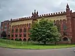
| |||
| 9, 11, 13 Watson Street, 31 Gallowgate | 55°51′24″N 4°14′34″W / 55.856712°N 4.242686°W | Category B | 33861 | Upload Photo | |||
| 105-169 (Odd Nos) Bell Street | 55°51′27″N 4°14′31″W / 55.857621°N 4.242083°W | Category A | 33814 | Upload Photo | |||
| 174 Bell Street | 55°51′25″N 4°14′27″W / 55.856872°N 4.240794°W | Category B | 33817 | Upload Photo | |||
| 40-42 (Even Nos) Bridgeton Cross And 3 Landressy Street | 55°50′57″N 4°13′39″W / 55.849243°N 4.227382°W | Category B | 33821 | Upload Photo | |||
| 2 Claythorn Street (Formerly 374, 378 Gallowgate) | 55°51′20″N 4°13′59″W / 55.85552°N 4.233094°W | Category B | 33824 | Upload Photo | |||
| 231 Dalmarnock Road, Bridgeton Free Church And Hall | 55°50′42″N 4°13′11″W / 55.845041°N 4.219682°W | Category B | 33825 | Upload Photo | |||
| 447-451 (Odd Nos) Gallowgate And 4 Graham Square | 55°51′20″N 4°13′39″W / 55.855676°N 4.227495°W | Category C(S) | 33833 | Upload Photo | |||
| 4 Florence Street/ Glasgow Green, Weir And Pipe Bridge | 55°51′07″N 4°14′45″W / 55.852036°N 4.24574°W | Category B | 33835 | 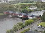
| |||
| 1, 1A Glasgow Green, People's Palace Museum And Winter Garden | 55°51′04″N 4°14′15″W / 55.851209°N 4.237416°W | Category A | 33838 | 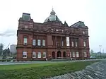
| |||
| 2-40 (Even Nos) Clarendon Place/ Maryhill Road And 281-297 (Odd Nos) St George's Road, Including Bank Of Scotland | 55°52′17″N 4°16′04″W / 55.871367°N 4.26786°W | Category B | 33755 | 
| |||
| 292-316 (Even Nos) Maryhill Road, Community Centre And Shops | 55°52′35″N 4°16′15″W / 55.876514°N 4.270958°W | Category C(S) | 33774 | 
| |||
| 61 Jessie Street, Sentinel Works | 55°50′07″N 4°14′32″W / 55.835275°N 4.242298°W | Category A | 33693 | Upload Photo | |||
| 192 Mcneil Street, Hutcheson Town Public Library (Now Day Nursery) | 55°50′46″N 4°14′32″W / 55.846126°N 4.24214°W | Category B | 33696 | Upload Photo | |||
| 110 Polmadie Road, St Margaret's Polmadie Church, Halls And Manse | 55°50′20″N 4°14′22″W / 55.838996°N 4.239318°W | Category B | 33698 | Upload Photo | |||
| 115 Carmunnock Road, Cathcart Old Parish Manse | 55°49′06″N 4°15′17″W / 55.818383°N 4.254799°W | Category B | 33706 | Upload Photo | |||
| 325 Carmunnock Road, King's Park, Aikenhead House, Sundial | 55°48′49″N 4°14′27″W / 55.813633°N 4.240813°W | Category B | 33712 | Upload Photo | |||
| 114 Crofthill Road, Croftpark Avenue, Croftfoot School | 55°48′54″N 4°14′02″W / 55.814891°N 4.233894°W | Category C(S) | 33713 | Upload Photo | |||
| Snuffmill Road, Cathcart Old Bridge | 55°48′49″N 4°15′33″W / 55.813745°N 4.259239°W | Category B | 33722 | Upload Photo | |||
| 694 Balmore Road, St Agnes Church (Roman Catholic) With Gatepiers, Boundary Walls And Railings | 55°53′45″N 4°15′49″W / 55.895784°N 4.263575°W | Category B | 33738 | Upload Photo | |||
| 127 Allander Street, Possilpark Library | 55°52′56″N 4°15′17″W / 55.882124°N 4.254721°W | Category B | 33741 | Upload Photo | |||
| 445 Balmore Road, Former Possil Goods Shed | 55°53′30″N 4°15′37″W / 55.891564°N 4.260402°W | Category C(S) | 33743 | Upload Photo | |||
| 85, 111 Killin Street, Shettleston Old Parish Church And Hall, Boundary Wall And Railings | 55°51′00″N 4°09′33″W / 55.84999°N 4.159256°W | Category B | 33637 | Upload Photo | |||
| 6-10 (Inclusive), 20-24 (Inclusive) And 30-43 (Inclusive) Parklands View, Former Leverndale Hospital, Kelburne Unit | 55°49′59″N 4°22′01″W / 55.833136°N 4.366944°W | Category B | 33596 | Upload Photo | |||
| 179 Ayr Street Springburn Library And Museum | 55°52′54″N 4°13′53″W / 55.881605°N 4.231443°W | Category B | 33610 | Upload Photo | |||
| Midwharf Street And North Canalbank Street, Forth And Clyde Canal, Bascule Bridge Including Stone Platforms/Abutments | 55°52′20″N 4°15′04″W / 55.872284°N 4.251193°W | Category B | 33617 | Upload Photo | |||
| 4-38 (Even Nos) Speirs Wharf | 55°52′20″N 4°15′27″W / 55.872269°N 4.257411°W | Category B | 33619 | Upload Photo | |||
| 122 Helenvale Street, Calton Parkhead Church Including Hall, Boundary Wall, Gates And Railings | 55°51′01″N 4°12′59″W / 55.850342°N 4.216278°W | Category B | 33636 | Upload Photo | |||
| 2-20 (Even Nos) Paisley Road West And Return Elevation To Govan Road | 55°51′14″N 4°16′47″W / 55.853804°N 4.279603°W | Category B | 33526 | Upload Photo | |||
| 100 Govan Road, Glasgow Harbour Tunnel, Otherwise Known As Finnieston Tunnel Shaft And Rotunda | 55°51′23″N 4°17′06″W / 55.8565°N 4.28497°W | Category B | 33528 | 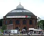
| |||
| 140 Salkeld Street And Return Elevation To Mauchline Street, Former Garage Now Strathclyde Police Mounted And Dog Branch | 55°50′52″N 4°15′43″W / 55.84775°N 4.261899°W | Category B | 33531 | Upload Photo | |||
| 173 Scotland Street, Former Subway Power Station | 55°50′57″N 4°16′18″W / 55.849152°N 4.271662°W | Category B | 33532 | Upload Photo | |||
| 1121 Paisley Road West, Palace Of Art | 55°50′51″N 4°19′06″W / 55.847501°N 4.31823°W | Category B | 33579 | 
| |||
| 494-8 (Even Nos) Paisley Road West | 55°51′04″N 4°18′03″W / 55.851241°N 4.300958°W | Category B | 33580 | Upload Photo | |||
| Crookston Castle, 170 Brockburn Road | 55°50′06″N 4°21′21″W / 55.83512°N 4.35587°W | Category A | 33586 | Upload Photo | |||
| 100 St Andrews Drive, Haggs Castle, Including Outbuilding | 55°50′11″N 4°17′45″W / 55.836407°N 4.295865°W | Category B | 33467 | Upload Photo | |||
| 35 Sherbrooke Avenue And 103 Springkell Avenue, Patrick House, Including Boundary Walls And Gatepiers | 55°50′21″N 4°17′55″W / 55.839233°N 4.298555°W | Category B | 33473 | Upload Photo | |||
| 85 Adelphi Street And 5 Florence Street, Glasgow College Of Building & Printing Annexe (Former Adelphi Terrace Public School), Including Gatepiers And Railings | 55°51′05″N 4°14′48″W / 55.851274°N 4.246655°W | Category B | 33491 | 
| |||
| 36-54 (Even Nos) Bridge Street, Former Bridge Street Station | 55°51′12″N 4°15′33″W / 55.853321°N 4.259043°W | Category B | 33496 | 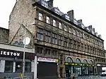
| |||
| 1 Caledonia Road, Former Caledonia Road UP Church | 55°50′50″N 4°15′17″W / 55.847181°N 4.254709°W | Category A | 33497 | 
| |||
| 27-117 (Odd Nos) Cook Street (Westbridge Gardens) And 181 And 183 West Street, Former Eglinton Engine Works | 55°51′03″N 4°15′54″W / 55.850831°N 4.264922°W | Category A | 33504 | Upload Photo | |||
| 119 Gorbals Street Citizens Theatre | 55°51′03″N 4°15′11″W / 55.850817°N 4.252955°W | Category B | 33512 | 
| |||
| 73 Milnpark Street, Kinning Park Colour Works | 55°51′06″N 4°16′57″W / 55.851537°N 4.282618°W | Category B | 33518 | Upload Photo | |||
| 187-203 (Odd Nos) Old Rutherglen Road | 55°50′57″N 4°14′49″W / 55.849037°N 4.247069°W | Category B | 33521 | Upload Photo | |||
| 50, 52 Glencairn Drive, Including Boundary Walls And Gatepiers | 55°50′21″N 4°16′58″W / 55.839105°N 4.282735°W | Category B | 33409 | Upload Photo | |||
| 23 Maxwell Drive, Including Boundary Walls And Gatepiers | 55°50′43″N 4°16′55″W / 55.845176°N 4.282053°W | Category C(S) | 33423 | Upload Photo | |||
| 33 Newark Drive, Including Boundary Walls And Gatepiers | 55°50′24″N 4°16′58″W / 55.839932°N 4.282736°W | Category B | 33430 | Upload Photo | |||
| 58 Newark Drive, Ardlui, Including Boundary Walls And Gatepiers | 55°50′27″N 4°17′13″W / 55.840778°N 4.28705°W | Category C(S) | 33437 | Upload Photo | |||
| 198 Nithsdale Road, Including Boundary Walls And Gatepiers | 55°50′32″N 4°17′08″W / 55.842088°N 4.28569°W | Category B | 33449 | Upload Photo | |||
| 99 Dougrie Road, St Margaret Mary's RC Church And Presbytery | 55°48′11″N 4°14′38″W / 55.803106°N 4.243942°W | Category B | 33331 | Upload Photo | |||
| 401 Govan Road, Summertown Road Carmichael Street 1-11 Merryland Street (Odd Nos) Former Govan Town Hall | 55°51′24″N 4°18′00″W / 55.856615°N 4.300013°W | Category B | 33340 | 
| |||
| 784-796 (Even Nos) Govan Road, New Govan, Formerly St Mary's, Church Hall And Shops Below | 55°51′46″N 4°18′40″W / 55.862743°N 4.311115°W | Category B | 33349 | Upload Photo | |||
| Govan Road, Govan Cross Drinking Fountain | 55°51′47″N 4°18′40″W / 55.863066°N 4.31115°W | Category B | 33350 | Upload Photo | |||
| 840, 860 Govan Road And Return Elevation To Pearce Street, Pearce Institute | 55°51′49″N 4°18′46″W / 55.863558°N 4.312714°W | Category A | 33352 | Upload Photo | |||
| 149-153 (Odd Nos) Albert Drive, St Alberts' Roman Catholic Church And Hall | 55°50′29″N 4°16′18″W / 55.841523°N 4.271552°W | Category B | 33367 | Upload Photo | |||
| 363 (Dunmorlie), 363A Albert Drive, Including Boundary Walls And Gatepiers | 55°50′37″N 4°17′33″W / 55.843742°N 4.292448°W | Category B | 33373 | Upload Photo | |||
| 50 Dalziel Drive, Including Boundary Walls And Gatepiers | 55°50′32″N 4°17′37″W / 55.842266°N 4.293543°W | Category B | 33374 | Upload Photo | |||
| 150-174 (Even Nos) Albert Drive And 88-92 (Even Nos) Forth Street, 59, 61 Glenapp Street | 55°50′31″N 4°16′15″W / 55.842004°N 4.270814°W | Category B | 33376 | Upload Photo | |||
| 336, 338 Albert Drive, Including Boundary Walls And Gatepiers | 55°50′40″N 4°17′11″W / 55.844456°N 4.286452°W | Category B | 33382 | Upload Photo | |||
| 23 Bruce Road | 55°50′40″N 4°17′02″W / 55.844479°N 4.283753°W | Category B | 33389 | Upload Photo | |||
| 38 And 38A Dalziel Drive, Hazliebrae, Including Boundary Walls And Gatepiers | 55°50′30″N 4°17′28″W / 55.841673°N 4.291112°W | Category B | 33396 | Upload Photo | |||
| 4 Nelson Mandela Place | 55°51′44″N 4°15′13″W / 55.862361°N 4.253719°W | Category A | 33233 | 
| |||
| 112, 114 West George Street And 46-50 (Even Nos) Renfield Street, Scottish Widows | 55°51′45″N 4°15′22″W / 55.862571°N 4.255985°W | Category B | 33238 | Upload Photo | |||
| 278 West George Street, Former St Jude's Church | 55°51′49″N 4°15′54″W / 55.86354°N 4.264863°W | Category B | 33250 | 
| |||
| 58, 60 West Nile Street and 23 Nelson Mandela Place, West George Street | 55°51′43″N 4°15′17″W / 55.861902°N 4.254747°W | Category B | 33253 | 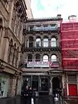
| |||
| 130-134 (Even Nos) West Nile Street | 55°51′49″N 4°15′15″W / 55.863729°N 4.254118°W | Category C(S) | 33256 | 
| |||
| 51-57 (Odd Nos) West Regent Street, 59-69 (Odd Nos) Renfield Street And 18-22 (Even Nos) West Regent Lane, Castle Chambers | 55°51′46″N 4°15′24″W / 55.862892°N 4.256643°W | Category B | 33257 | 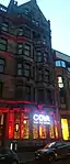
| |||
| 121 West Regent Street, Ailsa Court | 55°51′48″N 4°15′36″W / 55.863271°N 4.259941°W | Category C(S) | 33267 | Upload Photo | |||
| 98-104 (Even Nos) West Regent Street (Known As 100) | 55°51′49″N 4°15′30″W / 55.863544°N 4.258311°W | Category B | 33272 | Upload Photo | |||
| 130, 132 West Regent Street | 55°51′49″N 4°15′35″W / 55.863679°N 4.259757°W | Category C(S) | 33274 | Upload Photo | |||
| 148, 150 West Regent Street | 55°51′49″N 4°15′37″W / 55.863741°N 4.26032°W | Category B | 33276 | Upload Photo | |||
| Springburn Park, Winter Gardens | 55°53′20″N 4°13′37″W / 55.889°N 4.227038°W | Category A | 33298 | 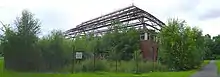
| |||
| 200 Shieldhall Road, Drumoyne Primary School, Janitor's Lodge Gatepiers And Boundary Walls | 55°51′22″N 4°19′55″W / 55.856032°N 4.331905°W | Category B | 33312 | Upload Photo | |||
| 201, 203 Pitt Street And 309-313 (Odd Nos) Sauchiehall Street | 55°51′55″N 4°15′54″W / 55.865336°N 4.264983°W | Category C(S) | 33177 | Upload Photo | |||
| 429-453 (Odd Nos) Sauchiehall Street | 55°51′57″N 4°16′10″W / 55.865921°N 4.269317°W | Category B | 33181 | 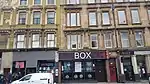
| |||
| 94-102 (Even Nos) Sauchiehall Street, Crown Rooms | 55°51′53″N 4°15′23″W / 55.864838°N 4.256356°W | Category B | 33188 | .jpg.webp)
| |||
| 116-120 (Even Nos) Sauchiehall Street And 257A, 259 Hope Street | 55°51′54″N 4°15′27″W / 55.86489°N 4.257446°W | Category B | 33189 | .jpg.webp)
| |||
| 500-516 (Even Nos) Sauchiehall Street, Known As 516 | 55°51′59″N 4°16′10″W / 55.866307°N 4.269355°W | Category B | 33197 | Upload Photo | |||
| 528-538 (Even Nos) Sauchiehall Street, Albany Chambers | 55°51′59″N 4°16′12″W / 55.866365°N 4.270078°W | Category A | 33199 | 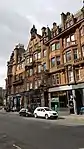
| |||
| 2-14 (Inclusive Nos) Somerset Place And 2, 4 Clifton Street (Sauchiehall Street) | 55°51′59″N 4°16′37″W / 55.866318°N 4.277012°W | Category B | 33202 | Upload Photo | |||
| 54-76 (Even Nos) Union Street And 55, 57, 63 Mitchell Street | 55°51′34″N 4°15′23″W / 55.859321°N 4.256292°W | Category B | 33206 | Upload Photo | |||
| 50 Waterloo Street With 81 Wellington Street, Former Waterloo Street Post Office, Parcels Office | 55°51′38″N 4°15′40″W / 55.860662°N 4.261068°W | Category A | 33214 | Upload Photo | |||
| 65 St Vincent Street And 26, 28 West Nile Street | 55°51′40″N 4°15′18″W / 55.861114°N 4.255037°W | Category B | 33132 | Upload Photo | |||
| 125, 127 St Vincent Street And 127, 129 Hope Street, Norwich Union Chambers | 55°51′41″N 4°15′31″W / 55.861469°N 4.258749°W | Category B | 33140 | 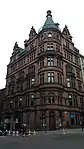
| |||
| 145 St Vincent Street, Wellington Street And 60-66 St Vincent Lane | 55°51′42″N 4°15′35″W / 55.861613°N 4.259701°W | Category B | 33142 | 
| |||
| 110, 120 St Vincent Street And 29-37 (Odd Nos) Renfield Street And West George Lane, Bank Of Scotland | 55°51′43″N 4°15′26″W / 55.861859°N 4.257094°W | Category A | 33156 | 
| |||
| 188-192 (Even Nos) St Vincent Street | 55°51′44″N 4°15′38″W / 55.862198°N 4.260662°W | Category C(S) | 33161 | _ST_VINCENT_STREET.jpg.webp)
| |||
| 2-5 (Inclusive Nos) La Belle Place | 55°52′00″N 4°16′47″W / 55.866554°N 4.279791°W | Category A | 33083 | Upload Photo | |||
| 60-76 (Even Nos) Mitchell Street, Former Glasgow Herald Building | 55°51′35″N 4°15′20″W / 55.859631°N 4.255559°W | Category A | 33087 | 
| |||
| 1-11 (Odd Nos) Renfield Street And 60-70 (Even Nos) Gordon Street | 55°51′39″N 4°15′26″W / 55.860811°N 4.257353°W | Category B | 33100 | 
| |||
| 194 Renfrew Street | 55°52′00″N 4°15′54″W / 55.866547°N 4.265102°W | Category C(S) | 33109 | Upload Photo | |||
| 71-75 (Odd Nos) Robertson Street And 58, 60 Robertson Lane | 55°51′30″N 4°15′42″W / 55.858244°N 4.261582°W | Category A | 33112 | Upload Photo | |||
| 15 - 21 (Odd Nos) Gordon Street | 55°51′37″N 4°15′19″W / 55.860205°N 4.255144°W | Category B | 33026 | Upload Photo | |||
| 2-10 (Even Nos) Bath Street And 229 Buchanan Street, Commercial Hotel | 55°51′49″N 4°15′12″W / 55.863618°N 4.253313°W | Category C(S) | 32964 | Upload Photo | |||
| 8-13 (Inclusive Nos) Known As 8 Blythswood Square, 173 West Regent Street, 258 West George Street, 135 West Regent Lane, Royal Scottish Automobile Club | 55°51′48″N 4°15′43″W / 55.863415°N 4.261883°W | Category B | 32976 | 
| |||
| 179 Buchanan Street, Former Athenaeum Theatre | 55°51′45″N 4°15′14″W / 55.862564°N 4.253923°W | Category A | 33004 | 
| |||
| 1-9 (Odd Nos) Corunna Street And 1131-1143 (Odd Nos) Argyle Street | 55°51′52″N 4°17′05″W / 55.864447°N 4.284846°W | Category B | 33013 | Upload Photo | |||
| 34, 38 Elliot Street (Known as 38 Elliot Street) | 55°51′43″N 4°16′45″W / 55.862011°N 4.279045°W | Category B | 33018 | 
| |||
| 17 Vinicombe Street, The Salon Including Boundary Wall and Railings | 55°52′37″N 4°17′26″W / 55.876948°N 4.290664°W | Category A | 32934 | 
| |||
| 145-167 (Odd Nos) Bath Street, 257 West Campbell Street, And 144-148 (Even Nos) Bath Lane | 55°51′51″N 4°15′42″W / 55.864273°N 4.261693°W | Category B | 32959 | Upload Photo | |||
| 201-205 (Odd Nos) Bath Street, Adelaide Place (South) | 55°51′52″N 4°15′51″W / 55.864462°N 4.264117°W | Category C(S) | 32961 | Upload Photo | |||
| University Avenue, University Of Glasgow, Gatepiers And Railings Quincentenary Gates | 55°52′20″N 4°17′17″W / 55.872231°N 4.28818°W | Category B | 32915 | 
| |||
| 3-9A (Odd Nos) Burgh Hall Street, Partick Burgh Halls | 55°52′17″N 4°18′31″W / 55.871355°N 4.308622°W | Category B | 32852 | .jpg.webp)
| |||
| 174, 176 Byres Road And 1, 3 Ashton Road | 55°52′28″N 4°17′39″W / 55.874556°N 4.294136°W | Category B | 32854 | 
| |||
| 41 Cresswell Street And 30 Cranworth Street, Hillhead Baptist Church | 55°52′34″N 4°17′29″W / 55.876045°N 4.291394°W | Category B | 32860 | Upload Photo | |||
| 121 Great George Street, Extension To Laurel Bank School, Former Belmont Church | 55°52′29″N 4°17′27″W / 55.874743°N 4.290854°W | Category B | 32871 | 
| |||
| 56 Glassford Street And 53 Hutcheson Street | 55°51′31″N 4°14′55″W / 55.858554°N 4.248609°W | Category C(S) | 32804 | Upload Photo | |||
| 76-84 (Even Nos) Wilson Street With 58-68 (Even Nos) Virginia Street | 55°51′32″N 4°14′58″W / 55.858935°N 4.249414°W | Category B | 32809 | Upload Photo | |||
| 4-6 (Even Nos) North Court | 55°51′39″N 4°15′09″W / 55.860695°N 4.252424°W | Category B | 32810 | 
| |||
| 32-44 (Even Nos) Queen Street | 55°51′31″N 4°15′07″W / 55.858673°N 4.251908°W | Category B | 32820 | Upload Photo | |||
| Queen Street Station, Train Shed And Bridge Over Railway On Cathedral Street | 55°51′45″N 4°15′04″W / 55.86247°N 4.2512°W | Category A | 32822 | .jpg.webp)
| |||
| Queen Street Duke Of Wellington Statue | 55°51′36″N 4°15′07″W / 55.8601°N 4.252038°W | Category A | 32823 | 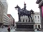
| |||
| 6 Rottenrow East And 1 Macleod Street, Castle Street, And Cathedral Square, Barony Church And Church Hall With War Memorial, Retaining Wall, Railings And Gatepiers | 55°51′43″N 4°14′14″W / 55.861882°N 4.237119°W | Category A | 32824 | 
| |||
| 102 Royston Road, Royston School, Formerly St Rollox School | 55°52′09″N 4°13′44″W / 55.869147°N 4.229018°W | Category B | 32829 | Upload Photo | |||
| 2 St Vincent Place And 2 And 4 Anchor Lane | 55°51′40″N 4°15′07″W / 55.861208°N 4.251911°W | Category A | 32838 | 
| |||
| 141-197 (Odd Nos) Howard Street With 63 Dunlop Street And 98-100 (Even Nos) Stockwell Street | 55°51′20″N 4°15′01″W / 55.855638°N 4.250294°W | Category B | 32725 | 
| |||
| 72-82 (Even Nos) Howard Street | 55°51′23″N 4°15′14″W / 55.856353°N 4.253947°W | Category B | 32727 | Upload Photo | |||
| 150 (Even Nos) Ingram Street | 55°51′35″N 4°14′50″W / 55.859774°N 4.247257°W | Category B | 32743 | Upload Photo | |||
| 61-63 (Odd Nos) Miller Street | 55°51′33″N 4°15′05″W / 55.859161°N 4.251281°W | Category A | 32758 | Upload Photo | |||
| 109-121 (Odd Nos) Trongate And 9 New Wynd, Including Britannia Panopticon Music Hall | 55°51′25″N 4°14′49″W / 55.856903°N 4.246964°W | Category A | 32774 | 
| |||
| 82-92 (Even Nos) Castle Street, Royal Infirmary, Including Clock Tower Building And Archway, Gates And Railings | 55°51′54″N 4°14′08″W / 55.864938°N 4.235617°W | Category B | 32650 | 
| |||
| Cathedral Square, Bridge Of Sighs, Gates, Gatepiers, And Lodge To Bridge Of Sighs With 50 Cathedral Square (Superintendent's House) | 55°51′45″N 4°14′08″W / 55.862395°N 4.235614°W | Category A | 32651 | 
| |||
| 20 Cathedral Square, Glasgow Evangelical Church; (Former Barony North Church) And Boundary Walls And Railings, And Church House, 14 Cathedral Square | 55°51′41″N 4°14′06″W / 55.861443°N 4.23508°W | Category A | 32652 | 
| |||
| 55-57 (Odd Nos) Cochrane Street And 20 South Frederick Street | 55°51′38″N 4°14′56″W / 55.860428°N 4.248845°W | Category C(S) | 32674 | Upload Photo | |||
| 9 Garth Street With 76 Glassford Street | 55°51′33″N 4°14′55″W / 55.859183°N 4.248597°W | Category B | 32684 | Upload Photo | |||
| 80 George Square Glasgow City Chambers And Lampbrackets To George Square | 55°51′40″N 4°14′55″W / 55.860988°N 4.24867°W | Category A | 32691 | 
| |||
| 44 Glassford Street | 55°51′30″N 4°14′56″W / 55.858341°N 4.248932°W | Category B | 32714 | Upload Photo | |||
| 252-284 (Even Nos) High Street And 1-5 (Odd Nos) Duke Street (Bell O'The Brae Tenements) | 55°51′38″N 4°14′20″W / 55.860547°N 4.23888°W | Category B | 32724 | 
| |||
| 49-51 (Inclusive Nos) Westbourne Gardens | 55°52′53″N 4°18′12″W / 55.881315°N 4.303233°W | Category B | 32604 | Upload Photo | |||
| 63 Argyle Street (Buck's Head Buildings) | 55°51′27″N 4°15′05″W / 55.85758°N 4.251269°W | Category A | 32608 | 
| |||
| 6-20 (Even Nos) Bell Street | 55°51′29″N 4°14′43″W / 55.857948°N 4.245394°W | Category B | 32622 | Upload Photo | |||
| 26-36 (Even Nos) Bell Street And 45 Albion Street | 55°51′28″N 4°14′42″W / 55.857856°N 4.244973°W | Category B | 32623 | Upload Photo | |||
| 102-104 Brunswick Street, Known As 104 Brunswick Street | 55°51′32″N 4°14′48″W / 55.858857°N 4.246773°W | Category B | 32627 | Upload Photo | |||
| 16 Buchanan Street | 55°51′31″N 4°15′16″W / 55.858565°N 4.254362°W | Category B | 32631 | 
| |||
| 116-128 (Even Nos) Buchanan Street And 41 St Vincent Place (St Vincent Chambers) | 55°51′39″N 4°15′13″W / 55.860842°N 4.253727°W | Category B | 32641 | 
| |||
| 125-127 (Odd Nos) Candleriggs | 55°51′34″N 4°14′44″W / 55.859357°N 4.245491°W | Category C(S) | 32646 | Upload Photo | |||
| 1 Princes Terrace, Prince Albert Road, With Gatepiers And Railings To Princes Terrace Lane | 55°52′37″N 4°18′03″W / 55.876931°N 4.300719°W | Category A | 32576 | 
| |||
| 33 Victoria Crescent Road, (Kings Gate) | 55°52′34″N 4°17′53″W / 55.875994°N 4.297962°W | Category B | 32595 | Upload Photo | |||
| 1 Lancaster Crescent, Gatepiers And Railings, Great Western Road | 55°52′58″N 4°18′09″W / 55.882657°N 4.302609°W | Category B | 32554 | Upload Photo |
Key
The scheme for classifying buildings in Scotland is:
- Category A: "buildings of national or international importance, either architectural or historic; or fine, little-altered examples of some particular period, style or building type."[1]
- Category B: "buildings of regional or more than local importance; or major examples of some particular period, style or building type, which may have been altered."[1]
- Category C: "buildings of local importance; lesser examples of any period, style, or building type, as originally constructed or moderately altered; and simple traditional buildings which group well with other listed buildings."[1]
In March 2016 there were 47,288 listed buildings in Scotland. Of these, 8% were Category A, and 50% were Category B, with the remaining 42% being Category C.[2]
See also
Notes
- ↑ Sometimes known as OSGB36, the grid reference (where provided) is based on the British national grid reference system used by the Ordnance Survey.
• "Guide to National Grid". Ordnance Survey. Retrieved 12 December 2007.
• "Get-a-map". Ordnance Survey. Retrieved 17 December 2007. - ↑ Historic Environment Scotland assign a unique alphanumeric identifier to each designated site in Scotland, for listed buildings this always begins with "LB", for example "LB12345".
References
- All entries, addresses and coordinates are based on data from Historic Scotland. This data falls under the Open Government Licence
- 1 2 3 "What is Listing?". Historic Environment Scotland. Retrieved 29 May 2018.
- ↑ Scotland's Historic Environment Audit 2016 (PDF). Historic Environment Scotland and the Built Environment Forum Scotland. pp. 15–16. Retrieved 29 May 2018.
This article is issued from Wikipedia. The text is licensed under Creative Commons - Attribution - Sharealike. Additional terms may apply for the media files.