This is a list of crossings of the Danube river, from its mouth in the Black Sea to its source in Germany. Next to each bridge listed is information regarding the year in which it was constructed and for what use it was constructed (foot bridge, bicycle bridge, road bridge or railway bridge), and the distance from the mouth of the river in kilometres where available.
Bridges not primarily intended for public use but which have limited access (generally only in the daytime and only for bicycle and foot traffic) are not included.
Romania
| Crossing | Distance from mouth (in km) | Carries | Location | Built | Coordinates | Photograph |
|---|---|---|---|---|---|---|
| Galați Tunnel | DN22E | Galați, I.C. Brătianu | (Proposed)[1] | 🌍 | ||
| Brăila Bridge | 165.8 | European route E87 | Brăila, Smârdan | 2018[lower-alpha 1] | 🌍 |  |
| Giurgeni – Vadu Oii Bridge | 238 | DN2A road | Giurgeni, Hârșova | 22 Dec 1970 | 🌍 |  |
| Anghel Saligny Bridge | 300 | Căile Ferate Române Line 800 | Cernavodă[3], Fetești[4] | 1895 | 🌍 | 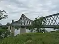 |
| Cernavodă Bridge | 300.07 | A2 motorway, Căile Ferate Române Line 800 | Cernavodă | 1987 | 🌍 | 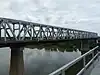 |
Romania-Bulgaria border
| Crossing | Distance from mouth (in km) | Carries | Location | Built | Coordinates | Photograph |
|---|---|---|---|---|---|---|
| Silistra-Călărași Hydrotechnical Complex | 380 | Silistra, Călărași | (Planned)[5] | |||
| Danube Bridge | 488.7 | European route E85, railway line | Ruse, Giurgiu | 20 Jun 1954 | 🌍 | 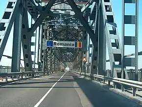 |
| Nikopol-Turnu Magurele Hydrotechnical Complex | 578 | Nikopol, Turnu Măgurele | (Proposed)[6] | 🌍 | ||
| Constantine's Bridge | Roman road | Sucidava | 328[lower-alpha 2] | 🌍 | ||
| Oryahovo–Bechet Bridge | Oryahovo, Bechet | (Planned) | ||||
| New Europe Bridge | 796 | European route E79, railway line[lower-alpha 3] | Calafat, Vidin | 14 Jun 2013 | 🌍 |  |
Romania–Serbia border
| Crossing | Distance from mouth (in kilometres) | Carries | Location | Built | Coordinates | Photograph |
|---|---|---|---|---|---|---|
| Ostrovul Mare Bridge | 863 | Road | Mehedinți County | 1998 | 🌍 |  |
| Iron Gate II Hydroelectric Power Station | 863 | DN56A | Gogoșu, Negotin Municipality | 1985 | 🌍 |  |
| Trajan's Bridge | Road | Drobeta-Turnu Severin | Built in 105 AD; destroyed. | 🌍 | .jpg.webp) | |
| Iron Gate I Hydroelectric Power Station | 945 | State road 35, European route E771, DN6A | Iron Gate | 7 Sep 1964 | 🌍 | 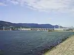 |
Serbia
| Crossing | Distance from mouth (in kilometres) | Carries | Location | Built | Coordinates | Photograph |
|---|---|---|---|---|---|---|
| Kovin Bridge | 1112.1 | Expressway 14 | Kovin, Smederevo | 26 Nov 1976[7] | 🌍 |  |
| Pančevo Bridge | European route E70 | Belgrade | 7 Nov 1946 | 🌍 | ||
| Pupin Bridge | Belgrade | 2014 | 🌍 |  | ||
| Beška Bridge (northbound) | 1232 | A1 motorway, European route E75 | Inđija | 2011 | 🌍 |  |
| Beška Bridge (southbound) | 1232 | A1 motorway, European route E75 | Inđija | 1975 | 🌍 | 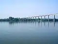 |
| Žeželj Bridge | 1254.1 | road, Railway | Novi Sad | 2018 | 🌍 |  |
| Boško Perošević Bridge | 1254.2 | Novi Sad | 2000 | 🌍 | 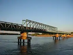 | |
| Varadin Bridge | 1255 | IIA-100 highway | Novi Sad | 2000 | 🌍 | |
| Liberty Bridge | 1257.6 | Liberation Boulevard | Novi Sad | 1981 | 🌍 |  |
Croatian–Serbian border
| Crossing | Distance from mouth (in kilometres) | Carries | Location | Built | Coordinates | Photograph |
|---|---|---|---|---|---|---|
| Ilok–Bačka Palanka Bridge | 1297 | D2 road, IIA-108 highway | Ilok, Bačka Palanka | 1974 | 🌍 |  |
| Erdut–Bogojevo Railway Bridge | Railway bridge | Erdut, Bogojevo | 1911 | 🌍 |  | |
| Erdut–Bogojevo Road Bridge | D213 road, Expressway 17 | Erdut, Bogojevo | 1980 | 🌍 | | |
| Batina Bridge | 1424.8 | D212 road, State Road 16 | Batina, Bezdan | 1974 | 🌍 |  |
Hungary
| Crossing | Distance from mouth (in kilometres) | Carries | Location | Opened | Coordinates | Photo |
|---|---|---|---|---|---|---|
| István Türr Bridge | 1480.22 | Hungarian road 55, Bátaszék–Baja–Kiskunhalas railway line | Baja, Pörböly | 1999 | 🌍 |  |
| Szent László bridge | 1498.8 | M9 motorway | Szekszárd, Dusnok | 2003 | 🌍 | 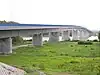 |
| József Beszédes Bridge | 1560.55 | Hungarian road 54 | Solt, Dunaföldvár | 2001 | 🌍 |  |
| Pentele Bridge | 1571.7 | M8 motorway | Dunaújváros, Dunavecse | 2007 | 🌍 | 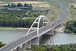 |
| Deák Ferenc Bridge | 1632.8 | M0 motorway | Szigetszentmiklós, Budapest | 2012 | 🌍 | 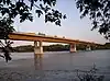 |
| Connective Railway Bridge | 1643 | Budapest–Hegyeshalom railway line | Budapest | 1953 | 🌍 | 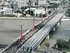 |
| Rákóczi Bridge | 1643 | Hungary boulevard | Budapest | 1995 | 🌍 | 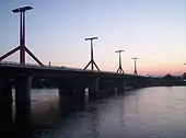 |
| Petőfi Bridge | 1644.3 | Grand Boulevard | Budapest | 1952 | 🌍 | 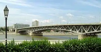 |
| Liberty Bridge | 1645.3 | Small Boulevard, Béla Bartók Avenue | Budapest | 2009 | 🌍 |  |
| Elisabeth Bridge | 1646 | Rákóczi Avenue, Hegyalja Avenue | Budapest | 1964[8] | 🌍 |  |
| Széchenyi Chain Bridge | 1647 | Adam Clark Square, Széchenyi István Square | Budapest | 1949 | 🌍 |  |
| Kossuth Bridge | Batthyány Square, Kossuth Square | Budapest | 18 Jan 1946 | 🌍 |  | |
| Margaret Bridge | 1648.75 | Grand Boulevard | Budapest | 2011 | 🌍 | .jpg.webp) |
| Árpád Bridge | 1651.3 | Hungary boulevard, Vörösvári út, Szentendrei út | Budapest | 7 Nov 1950 | 🌍 |  |
| Újpest railway bridge | 1654.5 | Budapest–Esztergom railway | Budapest | 1896 | 🌍 |  |
| Megyeri Bridge | 1660 | M0 motorway | Budapest, Dunakeszi | 30 Sep 2008 | 🌍 |  |
Hungaria-Slovakia border
| Crossing | Distance from mouth (in kilometres) | Carries | Location | Built | Coordinates | Photo |
|---|---|---|---|---|---|---|
| Mária Valéria Bridge | 1718.5 | Route I/63, Route 11326 | Esztergom, Štúrovo | 2001 | 🌍 |  |
| Elisabeth Bridge | 1767.8 | Hungarian road 13, route I/64 | Komárno, Komárom | 1946 | 🌍 | 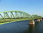 |
| Komárom rail bridge | 1770.4 | Komárom–Nové Zámky railway line | Komárom, Komárno | 1955 | 🌍 |  |
| Monostor Bridge | 1770.57 | Hungarian road 13, route I/64 | Komárom, Komárno | 2020 | 🌍 |  |
| Vámosszabadi bridge | 1806 | Hungarian road 14, route I/13 | Medveďov, Vámosszabadi | 1973 | 🌍 | 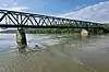 |
Slovakia
| Crossing | Distance from mouth (in km) | Carries | Location | Built | Coordinates | Photo |
|---|---|---|---|---|---|---|
| Čunovo Dam | Čunovo | 🌍 |  | |||
| Lužný most | D4 motorway | Bratislava | 2021 | 🌍 | .jpg.webp) | |
| Prístavný most | 1866.4 | Bratislava–Hegyeshalom railway line, D1 motorway | Bratislava | 1985 | 🌍 | 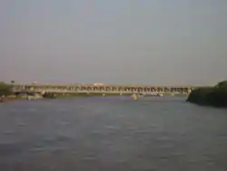 |
| Apollo Bridge | Bratislava | 4 Sep 2005 | 🌍 | |||
| Starý most | 1868.14 | tram tracks, with pedestrian and bicycle sidewalks | Bratislava | 1946[lower-alpha 4] | 🌍 | |
| Most SNP | 1869.1 | road bridge, bicycles, pedestrians | Bratislava[9] | 26 Aug 1972 | 🌍 | |
| Lanfranconi Bridge | 1871.35 | D2 motorway[lower-alpha 5] | Bratislava | 1991 | 🌍 | 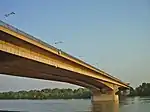 |
Austria
| Crossing | Distance from mouth (in km) | Carries | Location | Built | Coordinates | Photo |
|---|---|---|---|---|---|---|
| Andreas Maurer bridge | 1886.2 | Bernstein Straße | Hainburg an der Donau, Engelhartstetten | Dec 1972 | 🌍 | 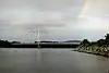 |
| Barbara bridge | 1914.4 | Gas pipe | Lower Austria | 1957 | 🌍 |  |
| Mannswörth pipeline bridge | 1917.7 | Gas pipe[lower-alpha 6][lower-alpha 7] | Lower Austria | 1959 | 🌍 |  |
| Weir 2[lower-alpha 8] | 1918.3 | Footpath | Vienna | 1988 | 🌍 |  |
| Waluliso Bridge[lower-alpha 9] | Footpath[lower-alpha 10] | Vienna | 1998 | 🌍 |  | |
| Freudenauer Hafenbrücke | 1921.1 | Covered pedestrian/bicycle path with viewing platform | Vienna | 1992 | 🌍 | |
| Steinsporn Bridge | Footpath | Vienna | 1974 | 🌍 |  | |
| Stadtlau East Railway Bridge | 1925 | Railway line | Donaustadt[10] | 1931 | 🌍 | 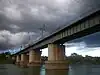 |
| Prater Bridge | 1925.8 | Vienna Southeast Bypass motorway A23 | Vienna | 1967[lower-alpha 11] | 🌍 | 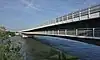 |
| Danube city bridge | 1926 | U2 | Vienna | Mar 1997 | 🌍 |  |
| Weir 1[lower-alpha 12] | 1926.2 | Footpath | Vienna | 1978 | 🌍 |  |
| Kaisermühlen Bridge | Footpath | Vienna | 1993 | 🌍 |  | |
| Reichsbrücke | 1928.9 | Angerner Straße, U1 | Leopoldstadt, Donaustadt, Vienna | 8 Nov 1980[11] | 🌍 | 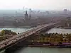 |
| Ponte Cagrana[lower-alpha 13] | pedestrian/bicycle access[lower-alpha 14] | Vienna | 2000 | 🌍 | ||
| Brigittenauer Bridge | 1930.4 | Klosterneuburger Straße | Vienna | 25 Oct 1982 | 🌍 |  |
| Georg Danzer Bridge | 1931.2 | U6 | Vienna | 1991 | 🌍 | 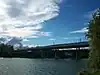 |
| Northern Railway Bridge | 1931.2 | North railway line | Vienna | 1870 | 🌍 |  |
| Floridsdorfer Brücke | 1931.7 | Floridsdorfer Straße | Vienna[12] | 1924[lower-alpha 15] | 🌍 |  |
| Steinitzsteg Footbridge | 1932.5 | Footpath | Vienna | 1995 | 🌍 |  |
| North Bridge | 1932.6 | Donauufer Autobahn | Vienna | 19 Dec 1964 | 🌍 | 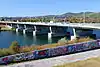 |
| Jedleseer Bridge | Footpath | Vienna | 1983 | 🌍 |  | |
| Langenzersdorf intake structure | 1938.1 | pedestrian/bicycle crossing between Langenzersdorf and the Danube Island | Klosterneuburg | 1975 | 🌍 | 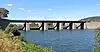 |
| Greifenstein power station | 1949.2 | Footpath | Sankt Andrä-Wördern, Spillern | 1981 | 🌍 |  |
| Donaubrücke Tulln | 1963.2 | Railway line, Tullner Straße | Tulln an der Donau | 1875 | 🌍 |  |
| Rose Bridge | 1965.4 | Tullner Straße | Tulln an der Donau | 1992 | 🌍 | |
| Altenwörth power station | 1980.4 | Footpath | Tulln an der Donau | 1973 | 🌍 | 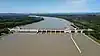 |
| Traismauer Danube motorway bridge | 1991.4 | S33 expressway | Lower Austria | 31 Oct 2010 | 🌍 |  |
| Krems Danube bridge | 1999.8 | Kremser Straße | Krems | 1971 | 🌍 | _Bridge_over_Danube_at_Krems_an_der_Donau%252C_Austria.jpg.webp) |
| Krems railway bridge | 2001.5 | Bahnstrecke Krems an der Donau - Herzogenburg | Lower Austria | 1889[lower-alpha 16] | 🌍 | .jpg.webp) |
| Mauterner Donaubrücke | 2003.6 | Aggsteiner Straße | Krems[13] | 18 May 1895 | 🌍 |  |
| Melk Danube Bridge | 2034.5 | Melker Straße | Melk | 1972 |  | |
| Melk power station dam | 2038 | Footpath | Melk | 1979 | 🌍 | _Bicycle_way_over_Kraftwerk_Melk%252C_Austria.jpg.webp) |
| Pöchlarn Danube bridge | 2043.6 | Pöchlarner Straße | Pöchlarn | 2002 | 🌍 |  |
| Persenbeug Dam | 2060.4 | Erlauftal Straße | Persenbeug | 1959 | 🌍 | |
| Leopold Helbich Bridge | 2080.8 | Greiner Straße | Grein | 1965 | 🌍 |  |
| Wallsee-Mitterkirchen power station | 2094.5 | road (L1427) | Mitterkirchen im Machland, Wallsee-Sindelburg | 1965 | 🌍 | |
| Mauthausen railway bridge | 2111.1 | Donauuferbahn, Summerauer Bahn | Mauthausen, Sankt Pantaleon-Erla | 1872 | 🌍 | .jpg.webp) |
| Mauthausen Danube bridge | 2111.1 | Mauthausener Straße | Mauthausen, Sankt Pantaleon-Erla | 1962 | 🌍 |  |
| Abwinden-Asten power station | 2119.6 | Footpath, bike path | Steyregg | 1973 | 🌍 |  |
| Steyregg Railway Bridge | 2127.6 | Summerauer Bahn | Steyregg, Linz | 1873 | 🌍 |  |
| Steyregg Bridge | 2127.7 | Donau Straße | Steyregg, Linz | 12 Sep 1979 | 🌍 |  |
| VÖEST Bridge | 2133.5 | Mühlkreis Autobahn | Upper Austria | 1968 | 🌍 |  |
| Eisenbahnbrücke, Linz | 2133.9 | railway, road (129), pedestrians - to be closed in 2012[14] | Linz | 1900 | 🌍 | |
| Nibelungen Bridge | 2135.1 | Eferdinger Straße | Linz | 1938 | 🌍 |  |
| Ottensheim-Wilhering power station | 2146.7 | Footpath, bike path | Upper Austria, Ottensheim | 1970 | 🌍 |  |
| Aschach Danube Bridge | 2160 | Aschacher Straße | Aschach an der Donau, Feldkirchen an der Donau | 1962[15] | 🌍 |  |
| Niederranna Danube bridge | 2194 | Niederranna-Wesenufer road (L587) | Upper Austria | 1980 | 🌍 |  |
Germany
| Crossing | Distance from mouth (in km) | Carries | Location | Built | Coordinates | Photo |
|---|---|---|---|---|---|---|
| Jochenstein power station | 2203.31 | Footpath[lower-alpha 17] | Untergriesbach, Engelhartszell an der Donau[16] | 1956, 1952 | 🌍 |  |
| Kräutlstein Bridge | 2223.29 | Passau–Hauzenberg railway | Passau | 1903 | 🌍 | |
| Luitpold Bridge | 2225.75 | Passau | 1910 | 🌍 | 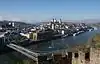 | |
| Schanzl Bridge | 2226.98 | Passau | 1968 | 🌍 |  | |
| Franz Josef Strauß Bridge | 2230.1 | Bundesstraße 12 | Passau | 1989 | 🌍 |  |
| Steinbach railway bridge | 2230.28 | Passau Hbf–Freyung railway | Passau |  | ||
| Kachlet power station weir | 2230.43 | Footpath | Passau | 🌍 |  | |
| Schalding motorway bridge | 2234.26 | Bundesautobahn 3 | Passau | 1973 | 🌍 | |
| Marienbrücke | 2249.16 | Vilshofen | 🌍 | 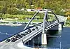 | ||
| Danube Forest Bridge | 2266.23 | Winzer | ||||
| Deggenau Danube bridge | 2282.5 | Bundesautobahn 3 | Deggendorf | 1975 | 🌍 |  |
| Maximilian Bridge | 2284.6 | Staatsstraße 2074 | Deggendorf | 1999 |  | |
| Fischerdorf motorway bridge | 2285.5 | Bundesautobahn 92 | Deggendorf | 1991 | 🌍 | 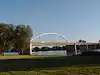 |
| Donausteg Deggendorf | 2285.87 | Footpath | Deggendorf | 11 Oct 2014 | 🌍 | _2018.jpg.webp) |
| Deggendorf railway bridge | 2285.87 | Bavarian Forest Railway | Deggendorf | 1877 | ||
| Metten motorway bridge | 2290.12 | Bundesautobahn 3 | Metten | 1981 | 🌍 |  |
| Xaver Hafner Bridge | 2308.4 | Bogen | 19 Sep 1986 | 🌍 |  | |
| Bogen railway bridge | 2311.28 | Straubing–Miltach railway | Aiterhofen | 1895 | 🌍 | |
| Reibersdorf road bridge | 2316.98 | Bundesstraße 20 | Straubing | 1 Jul 1977 | 🌍 |  |
| Schloßbrücke | 2321.33 | Chamer Straße, Bavarian State Route 2141 | Straubing | 1949 | 🌍 | 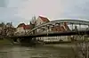 |
| Agnes Bernauer Bridge | 2320 | Bavarian State Route 2141 | Straubing | Nov 1981 | 🌍 |  |
| Kagerser Bridge | 2321.82 | Straubing west bypass | Straubing | 7 Aug 1992 | 🌍 |  |
| Donaubrücke Pfatter | 2353.33 | Bavarian State Route 2146 | Wörth an der Donau |  | ||
| Wörth Danube Bridge | 2358.27 | Bundesautobahn 3 | Wörth an der Donau | 1979 | 🌍 | 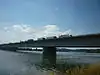 |
| Donaustauf road bridge | 2369.65 | Bavarian State Route 2145 | Donaustauf | 1985 | ||
| Schwabelweis road bridge | 2376.32 | Bundesstraße 8, Bundesstraße 15 | Regensburg | 1981 | 🌍 |  |
| Schwabelweis railway bridge | 2376.82 | Regensburg–Weiden railway | Schwabelweis | 1933 | 🌍 | |
| Nibelungen Bridge | 2378.39 | Bundesstraße 15 | Regensburg | 2004[lower-alpha 18] | 🌍 | .jpg.webp) |
| Gries foot and bicycle bridge[lower-alpha 19] | 2379.27 | Footpath | Regensburg | 🌍 |  | |
| Iron Bridge | 2379.26 | Regensburg[12] | 1991 | 🌍 |  | |
| Protzenweiher Bridge[lower-alpha 20] | 2379.56 | Regensburg | 2011 |  | ||
| Stone Bridge | 2379.62 | Regensburg[12] | 1146 | 🌍 | ||
| Eiserner Steg | 2380.07 | Footpath | Regensburg | 1948 | 🌍 | 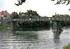 |
| Pfaffenstein footbridge[lower-alpha 21] | 2380.12 | Footpath | Regensburg |  | ||
| Upper Palatinate Bridge[lower-alpha 22] | 2380.17 | Regensburg | 🌍 | |||
| Regensburg hydroelectric power station | 2381 | Footbridge | Regensburg | 🌍 | ||
| Pfaffenstein motorway bridge | 2381.11 | Bundesautobahn 93 | Regensburg | 1967 | 🌍 |  |
| Mariaort railway bridge | 2385.68 | Nuremberg–Regensburg railway | Mariaort | 1872 | 🌍 | 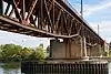 |
| Sinzing railway bridge | 2386.71 | Danube Valley Railway | Sinzing | 🌍 | ||
| Sinzing motorway bridge | 2387.6 | Bundesautobahn 3 | Regensburg | 1966 | 🌍 |  |
| Bad Abbach power station | 2400.24 | Bad Abbach | 🌍 | 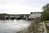 | ||
| Poikam railway bridge | 2401.96 | Regensburg–Ingolstadt railway | Poikam | |||
| Saal road bridge | 2410.1 | Saal an der Donau | ||||
| Kelheim Europa Bridge | 2412.72 | Kelheim | 1977 | 🌍 |  | |
| Kelheim Maximilian Bridge | 2414.25 | Kelheim |  | |||
| Neustadt road bridge | 2432.4 | Bundesstraße 299 | Neustadt an der Donau | .JPG.webp) | ||
| Pförring road bridge | Pförring | 🌍 | ||||
| New Danube Bridge | Vohburg an der Donau[lower-alpha 23] | 🌍 | ||||
| Old Danube Bridge | Bundesstraße 16a | Vohburg an der Donau | 🌍 | |||
| Vohburg weir | Vohburg an der Donau | 🌍 |  | |||
| Großmehring road bridge | Großmehring | 🌍 | ||||
| Motorway bridge A9 | Bundesautobahn 9 | Ingolstadt | 🌍 | |||
| Schiller bridge | Bundesstraße 13 | Ingolstadt | 1963 | 🌍 | ||
| Ingolstadt Rail Bridge | Nuremberg–Ingolstadt high speed railway | Ingolstadt | 1922[lower-alpha 24] | 🌍 |  | |
| Donausteg | Ingolstadt | 🌍 |  | |||
| Konrad-Adenauer-Brücke | Ingolstadt | 1948 | 🌍 |  | ||
| Glacis Bridge | Bundesstraße 13, Ringstraße | Ingolstadt | 1998 | 🌍 |  | |
| Ingolstadt power station dam | Ingolstadt | 1971 | 🌍 |  | ||
| Bergheim power station dam | Bergheim, Neuburg an der Donau | 1970 | 🌍 |  | ||
| Elisa Bridge | Neuburg an der Donau | 🌍 |  | |||
| Bittenbrunn power station dam | Neuburg an der Donau | 1969 | 🌍 |  | ||
| Bertoldsheim power station dam | Rennertshofen | 1967 | 🌍 |  | ||
| Marxheim Danube Bridge | Marxheim | 🌍 |  | |||
| Schäfstall Bridge | Schäfstall | 🌍 | ||||
| B2 road bridge | Bundesstraße 2 | Donauwörth | 🌍 | |||
| Donauwörth Danube bridge | Donauwörth | 🌍 | .jpg.webp) | |||
| Railway bridge | Danube Valley Railway | Donauwörth | 🌍 | |||
| Kesseldamm Bridge | Bundesstraße 16 | Donauwörth | 🌍 | |||
| Donauwörth power station dam | Donauwörth | 🌍 |  | |||
| Donaubrücke Donaumünster | Donaumünster | 2007[17] | 🌍 |  | ||
| Schwenningen power station | Schwenningen | 1983 | 🌍 | |||
| Donaubrücke Gremheim | Gremheim | 🌍 | ||||
| Donaubrücke Bruckmahdseen | Blindheim | 🌍 | ||||
| Donaubrücke Steinheim | Steinheim | 🌍 | ||||
| Crossing | Distance from mouth | Carries | Location | Built | Coordinates |
|---|---|---|---|---|---|
| Donaueschingen road bridge | Bundesstraße 27 | Donaueschingen Brigach-Breg rivers |
47°57′19″N 8°29′24″E / 47.95524°N 8.490115°E | ||
| motorway bridge | Bundesautobahn 81 | Geisingen | |||
| Bundesstraße 14 | Tuttlingen | ||||
| 2,710 km (1,680 mi) | Nendingen | 1902 | |||
| Bundesstraße 32 | Sigmaringen/Mengen | ||||
| Munderkingen | 1893 | ||||
| Oberdischingen/Ersingen road bridge | 2,602.55 km (1,617.15 mi) | k7412 | Ulm/Neu-Ulm | ||
| Ersingen weir | 2,600.83 km (1,616.08 mi) | ||||
| Road bridge | 2,600.79 km (1,616.06 mi) | Im Ried | |||
| bicycle/pedestrian bridge | 2,599.01 km (1,614.95 mi) | Laupheimer Straße | |||
| Railway bridge | 2,598.99 km (1,614.94 mi) | Ulm–Augsburg railway | |||
| Road bridge | 2,598.20 km (1,614.45 mi) | Donaustraße | |||
| Road bridge over Danube Canal | Im Ried | ||||
| Field path crossing over Danube Canal | |||||
| Railway bridge over Danube Canal | |||||
| Field path crossing over Danube Canal | |||||
| Road bridge over Danube Canal | Donaustraße | ||||
| Field path crossing over Danube Canal | Reprechweg | ||||
| Power plant crossing over Danube Canal (with disused sluice) | 2595.8 km2,595.8 km (1,613.0 mi) | ||||
| Donaustetten road bridge | 2,595.44 km (1,612.73 mi) | ||||
| Gögglingen road bridge | 2,593.63 km (1,611.61 mi) | ||||
| Gronne footbridge | 2,591.26 km (1,610.13 mi) | ||||
| Kast Bridge | 2,590.78 km (1,609.84 mi) | ||||
| Footbridge at Wiblingen hydro-power station | 2,589.16 km (1,608.83 mi) | ||||
| Adenauer Bridge | 2,586.60 km (1,607.24 mi) | Bundesstraße 10 | |||
| Adenauer Bridge footbridge | 2,586.58 km (1,607.23 mi) | ||||
| Railway bridge | 2,586.20 km (1,606.99 mi) | ||||
| Herd Bridge | 2,585.50 km (1,606.56 mi) | ||||
| Gänstor Bridge | 2,584.90 km (1,606.18 mi) | ||||
| Friedrichsau footbridge | 2,583.50 km (1,605.31 mi) | ||||
| Böfinger Halde hydro-power station, with sluice | 2,581.60 km (1,604.13 mi) | ||||
| Thalfingen road bridge | 2,579.00 km (1,602.52 mi) | ||||
| Leibi–Oberelchingen road bridge | 2,576.00 km (1,600.65 mi) | ||||
| Oberelchingen hydro-power station (no public crossing, with sluice) | 2,575.00 km (1,600.03 mi) | ||||
| Motorway bridge with footbridge | 2,574.90 km (1,599.97 mi) | Bundesautobahn 7 | |||
| Leipheim hydro-power station (no public crossing, with sluice) | 2,568.50 km (1,595.99 mi) | Günzburg | |||
| Leipheim motorway bridge | 2,567.51 km (1,595.38 mi) | Bundesautobahn 8 | 2001 | ||
| Leipheim road bridge (direct boat to train access) | 2,566.50 km (1,594.75 mi) | ||||
| Power station | |||||
| Road bridge | Heidenheimer Straße (Günzburg–Niederstotzingen) | ||||
| Road bridge | Bundesstraße 16 | ||||
| Road bridge at Reisensburg | |||||
| Hydro-power station (no public crossing) | Offingen | ||||
| Railway bridge | Ingolstadt–Neuoffingen railway | ||||
| Road bridge | Gundelfingen-Offingen road | ||||
| Faimingen hydro-power station | Lauingen | ||||
| Road bridge | Lauingen-Gundremmingen road | ||||
| Road bridge | Lauingen east bypass | ||||
| Hydro-power station | Dillingen an der Donau | ||||
| Road bridge | Dillingen-Holzheim road | ||||
| Road bridge | Höchstädt-Wertingen road | Höchstädt an der Donau |
Notes
- ↑ The largest bridge over the Danube[2]
- ↑ Destroyed mid-4th century
- ↑ between CFR Line 912 and BDZ Line 7
- ↑ Replacing 1891 Franz Joseph Bridge (most Františka Jozefa - originally a railway bridge), demolished and rebuilt 2013-2016
- ↑ also bicycle and pedestrian path, water and gas pipes
- ↑ 20 pipes for natural gas and liquid petroleum products
- ↑ Non-public footbridge
- ↑ across New Danube
- ↑ Across New Danube
- ↑ Closed in winter and high water
- ↑ widened and raised 1996-97
- ↑ Across New Danube
- ↑ Across New Danube
- ↑ closed in winter and high water
- ↑ replacing 1874 Franz Joseph Bridge; rebuilt 1945-46
- ↑ rebuilt 1945
- ↑ Openable bridge
- ↑ Other bridges were built 1935–1938; 1950; 2001–04
- ↑ Between island Wöhrd and Stadtamhof
- ↑ Across Rhine-Main-Danube Canal (now closed to traffic)
- ↑ Between island (Wöhrd) and Stadtamhof
- ↑ Across the Rhine–Main–Danube Canal
- ↑ road bridge bypassing town centre
- ↑ also 1869, 1999–2001
References
- ↑ "Consiliul Judeţean Brăila > Consiliul Judetean Braila > Judetul Braila > Oportunităţi > Pod peste Dunare la Braila". Archived from the original on 2014-04-08. Retrieved 2014-04-08.
- ↑ "EU Cohesion Policy: The largest bridge over the Danube opens for circulation". ec.europa.eu. 6 July 2023. Retrieved 11 July 2023.
- ↑ https://tools.wmflabs.org/heritage/api/api.php?action=search&format=json&srcountry=ro&srlang=ro&srid=CT-II-m-A-02872
- ↑ https://tools.wmflabs.org/heritage/api/api.php?action=search&format=json&srcountry=ro&srlang=ro&srid=IL-II-a-A-14114
- ↑ "Southeast European Cooperative Initiative - SECI". Archived from the original on 2011-09-29. Retrieved 2010-06-20.
- ↑ "Southeast European Cooperative Initiative - SECI". Archived from the original on 2011-09-29. Retrieved 2010-06-20.
- ↑ https://sdcafe.rs/smederevski-most-na-dunavu-postojao-jos-pre-100-godina/
- ↑ https://www.sulinet.hu/oroksegtar/data/tudomany_es_ismeretterjesztes/A_budapesti_duna_hidak/
- ↑ No label or title -- debug: Q112086059, Wikidata Q112086059
- ↑ https://tools.wmflabs.org/heritage/api/api.php?action=search&format=json&srcountry=at&srlanguage=de&srid=11306
- ↑ https://structurae.net/en/structures/reichsbrucke
- 1 2 3 archINFORM (in German, English, French, Spanish, and Italian), OCLC 45382278, Wikidata Q265049
- ↑ https://tools.wmflabs.org/heritage/api/api.php?action=search&format=json&srcountry=at&srlanguage=de&srid=77446
- ↑ "Eisenbahnbrücke nur noch bis Ende 2012 befahrbar", Oberösterreichische Nachrichten, 7 April 2010 (German), retrieved 23 May 2010.
- ↑ https://www.land-oberoesterreich.gv.at/13758.htm
- ↑ https://tools.wmflabs.org/heritage/api/api.php?action=search&format=json&srcountry=at&srlanguage=de&srid=128983
- ↑ "Einweihung der neuen Donaubrücke in Donaumünster ein Tag der Freude", Schwabmünchner Allgemeine 19 September 2007, retrieved 5 May 2010 (German).
External links
- (in German) Liste sämtlicher Brücken über die Donau (PDF) – Quelle: donauschifffahrt.info
- (in German) Liste der Schleusen – Quelle: donauschifffahrt.info /
- (in German) Die Donau ~ Faszination eines Flusses
- (in German) Die interaktive Kulturkarte entlang der Donau
- (in German) Arbeitsgemeinschaft Donauländer Archived 2017-07-24 at the Wayback Machine
- (in German) Wiener Donaubrücken
- (in German) Donaubrücken bei brueckenbau-links.de
| Countries |  | |
|---|---|---|
| Cities | ||
| Tributaries | ||
| Canals | ||
| See also | ||
This article is issued from Wikipedia. The text is licensed under Creative Commons - Attribution - Sharealike. Additional terms may apply for the media files.