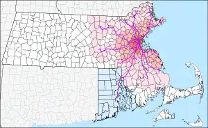

MBTA Commuter Rail is the commuter rail system for the Greater Boston metropolitan area of Massachusetts. It is owned by the Massachusetts Bay Transportation Authority (MBTA) and operated under contract by Keolis. In 2022, it was the fifth-busiest commuter rail system in the United States with an average weekday ridership of 78,800.[1] The system's routes span 394 miles (630 km) and cover roughly the eastern third of Massachusetts plus central Rhode Island.[2][3] They stretch from Newburyport in the north to North Kingstown, Rhode Island, in the south, and reach as far west as Worcester and Fitchburg. The system is split into two parts, with lines north of Boston having a terminus at North Station and lines south of Boston having a terminus at South Station.
As of December 2023, there are 135 active stations on twelve lines, two of which have branches. 108 active stations are accessible; 26 are not. Six additional stations (Prides Crossing, Mishawum, Hastings, Silver Hill, Plimptonville, and Plymouth) are indefinitely closed due to service cuts during the COVID-19 pandemic. Two stations (Winchester Center and South Attleboro) are temporarily closed due to structural deterioration. Six additional stations are under construction as part of the South Coast Rail project; several other stations are planned.
The MBTA was formed in 1964 to subsidize suburban commuter rail service operated by the Boston and Maine Railroad, New York Central Railroad, and New York, New Haven and Hartford Railroad. Subsidies began in stages from 1965 to 1973; a number of stations closed in 1965–1967 before service to them was subsidized, of which 26 have not reopened. Contraction continued into the early 1980s; 42 additional stations closed between 1967 and 1981 have not reopened. Expansion of the system began in the late 1970s, including extensions of existing lines and the reopening of several lines discontinued before the MBTA era. Three additional low-ridership stations have closed since 1981, while several others have been relocated.
Key
| Station | Indicates the MBTA's official name for the station. |
| Indicates whether the station is accessible. (See MBTA accessibility for further details.) | |
| Line | Indicates the lines that stop at the given station. A bold line designation indicates that the station is a terminus for that line. |
| Connections | Denotes any links to MBTA subway and MBTA bus routes, to other bus systems, to Amtrak trains, or to the CapeFLYER at the station. |
| City/neighborhood | Identifies the municipality (and for Boston, the neighborhood) in which the station is located. |
| Fare zone | Identifies which of the eleven fare zones the station is in. The zones are 1A, 1, 2, 3, 4, 5, 6, 7, 8, 9, and 10, with Zone 1A being the closest to North Station and South Station, and Zone 10 being the farthest. |
| Daily boardings | Average daily boardings (in both directions) from an April 2018 count. |
| Station info | A link to the station's information page on the MBTA website. |
Stations
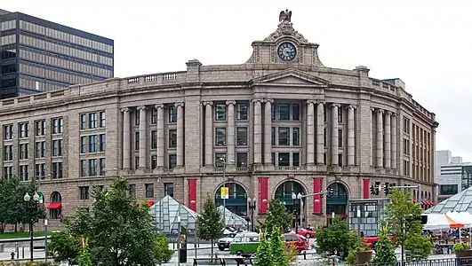 South Station is the busiest MBTA Commuter Rail station and the terminal for the eight southside lines.
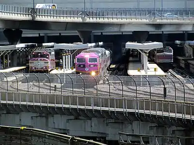 North Station is the second-busiest station and the terminal for the four northside lines.
%252C_June_2017.JPG.webp) Route 128 station, on the busy Northeast Corridor, is used by Providence/Stoughton Line trains (shown) as well as Amtrak trains.
Route 128 station, on the busy Northeast Corridor, is used by Providence/Stoughton Line trains (shown) as well as Amtrak trains.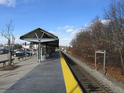 Campello station, a typical accessible station with a full-length high-level platform
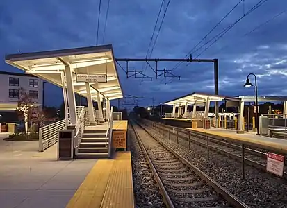 Accessible mini-high platforms at Mansfield station
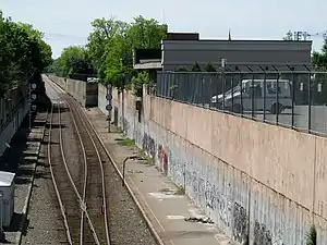
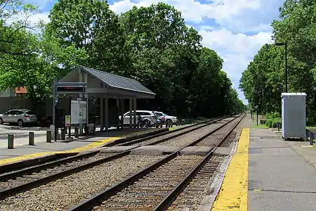 Islington station, a typical non-accessible station with low-level platforms
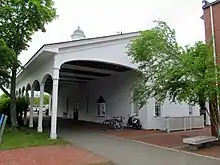
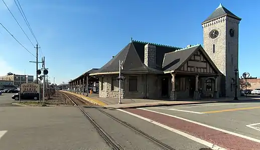 Stoughton station is one of a number of stations on the system with preserved historic depot buildings.
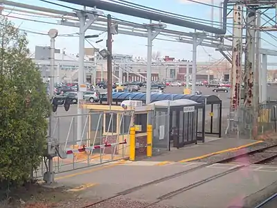 River Works station, the only non-public station on the system, is for use only by employees of a General Electric plant.
Future stations
Under construction
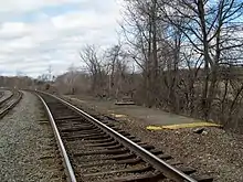
%252C_August_2023.jpg.webp)
Six stations are under construction as part of the South Coast Rail project.
| Station | Line | City | Planned opening | Refs |
|---|---|---|---|---|
| Middleborough | Middleborough | mid-2024 | [6] | |
| East Taunton | East Taunton | mid-2024 | [6] | |
| Church Street | New Bedford | mid-2024 | [6] | |
| New Bedford | New Bedford | mid-2024 | [6] | |
| Freetown | Freetown | mid-2024 | [6] | |
| Fall River | Fall River | mid-2024 | [6] |
Planned
Five additional stations are planned, but not funded, as part of the second phase of the South Coast Rail project. West Station is planned as part of the redevelopment of the former Beacon Park Yard, while South Salem is municipally planned.
| Station | Line | City | Refs |
|---|---|---|---|
| Battleship Cove | Fall River | [7] | |
| Easton Village | North Easton | [7] | |
| North Easton | North Easton/Stoughton | [7] | |
| Raynham Place | Raynham | [7] | |
| South Salem | Salem | [8] | |
| Taunton | Taunton | [7] | |
| West Station | Boston | [9] |
Former stations
Stations closed without MBTA subsidy
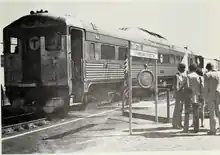
.jpg.webp)
The MBTA was formed in August 1964 to subsidize suburban commuter rail services. Subsidies for Boston and Maine Railroad (B&M) lines north of Boston began in 1965; subsidies for New York Central Railroad and New Haven Railroad lines west and south of Boston began later.[10] If a railroad was given ICC permission to discontinue a service, the MBTA would subsidize operation within its funding district (within about 15–25 miles [24–40 km] of Boston), while municipalities outside the district could contract with the MBTA to fund continued service.
A number of out-of-district stations (and several in-district stations) were closed in January 1965; most reopened that June, or over the next decades. However, several minor stations were never reopened. In June 1967, the B&M discontinued never-subsidized Boston–Dover and Boston–Concord round trips - the last remains of B&M interstate service.[10] Several out-of-district stations were also closed in April 1966 when the MBTA began subsidizing several New Haven Railroad lines.[10]
This listing includes only stations closed when MBTA or local subsidies began, or on services that were never subsidized. Stations that later reopened are not listed.
| Station | Line | City | Date closed[10] |
|---|---|---|---|
| Blackstone | Blackstone Line | Blackstone | April 24, 1966 |
| Medway | West Medway Branch | Medway | April 24, 1966 |
| West Medway | West Medway Branch | Medway | April 24, 1966 |
| Ordway | Central Mass Branch | Hudson | January 18, 1965 |
| Gleasondale | Central Mass Branch | Hudson | January 18, 1965 |
| Hudson | Central Mass Branch | Hudson | January 18, 1965 |
| Riverview | Fitchburg Line | Waltham | January 18, 1965 |
| Walnut Hill | Lowell Line | Woburn | January 18, 1965 |
| Silver Lake | Lowell Line | Wilmington | January 18, 1965 |
| East Billerica | Lowell Line | Billerica | January 18, 1965 |
| North Chelmsford | Boston–Concord | Chelmsford | June 30, 1967 |
| Wakefield Junction | Reading Line | Wakefield | January 18, 1965 |
| Salem Street | Boston–Dover | Wilmington | June 30, 1967 |
| Atkinson | Boston–Dover | Atkinson, NH | June 30, 1967 |
| Plaistow | Boston–Dover | Plaistow, NH | June 30, 1967 |
| Newton Junction | Boston–Dover | Newton, NH | June 30, 1967 |
| Powwow River | Boston–Dover | East Kingston, NH | June 30, 1967 |
| East Kingston | Boston–Dover | East Kingston, NH | June 30, 1967 |
| Exeter | Boston–Dover | Exeter, NH | June 30, 1967 |
| Newfields | Boston–Dover | Newfields, NH | June 30, 1967 |
| Newmarket | Boston–Dover | Newmarket, NH | June 30, 1967 |
| Durham | Boston–Dover | Durham, NH | June 30, 1967 |
| Dover | Boston–Dover | Dover, NH | June 30, 1967 |
| Hampton | Portsmouth Line | Hampton, NH | January 4, 1965 |
| North Hampton | Portsmouth Line | North Hampton, NH | January 4, 1965 |
| Portsmouth | Portsmouth Line | Portsmouth, NH | January 4, 1965 |
Stations dropped after the start of MBTA subsidies
The following stations had MBTA-subsidized service at one point, but are no longer served by the MBTA. Most were closed between 1967 and 1981, as four limited-service lines and a number of low-ridership stations were dropped. Three additional low-ridership stations were dropped in the 1980s and 1990s.[10]
| Station | Line | City | Date closed[10][11] |
|---|---|---|---|
| Mount Hope | Boston/Roslindale | November 3, 1979 | |
| East Foxboro | Foxborough | November 1977 | |
| East Dedham | Dedham | April 21, 1967 | |
| Stone Haven | Dedham | April 21, 1967 | |
| Dedham | Dedham | April 21, 1967 | |
| Charles River | Dover | April 21, 1967 | |
| Dover | Dover | April 21, 1967 | |
| Farm Street | Medfield | April 21, 1967 | |
| Medfield | Medfield | April 21, 1967 | |
| Clicquot | Millis | April 21, 1967 | |
| Millis | Millis | April 21, 1967 | |
| Riverside | Newton | October 28, 1977 | |
| Waltham North | Waltham | November 26, 1971 | |
| Waltham Highlands | Waltham | November 26, 1971 | |
| Weston | Weston | November 26, 1971 | |
| Cherry Brook | Weston | November 26, 1971 | |
| Tower Hill | Wayland | November 26, 1971 | |
| Wayland | Wayland | November 26, 1971 | |
| East Sudbury | Sudbury | November 26, 1971 | |
| South Sudbury | Sudbury | November 26, 1971 | |
| Clematis Brook | Waltham | June 1978 | |
| Beaver Brook | Waltham | June 1978 | |
| West Acton | Acton | March 1, 1975 | |
| Littleton | Littleton | March 1, 1975 | |
| Gardner | Gardner | December 31, 1986 | |
| Lake Street | Arlington | January 10, 1977 | |
| Arlington | Arlington | January 10, 1977 | |
| East Lexington | Lexington | January 10, 1977 | |
| Pierce's Bridge | Lexington | January 10, 1977 | |
| Munroe | Lexington | January 10, 1977 | |
| Lexington | Lexington | January 10, 1977 | |
| North Lexington | Lexington | January 10, 1977 | |
| Bedford | Bedford | January 10, 1977 | |
| Tufts University | Medford | October 1979 | |
| Cross Street | Woburn | January 30, 1981 | |
| Woburn | Woburn | January 30, 1981 | |
| Winchester Highlands | Winchester | June 1978 | |
| Lechmere Warehouse | Woburn | 1996 | |
| Nashua | Nashua, NH | March 1, 1981 | |
| Merrimack | Merrimack, NH | March 1, 1981 | |
| Manchester | Manchester, NH | March 1, 1981 | |
| Concord | Concord, NH | March 1, 1981 | |
| Shawsheen | Andover | April 27, 1980 | |
| North Andover | North Andover | November 1974 | |
| Harbor | Gloucester | January 7, 1985 |
Relocated stations
Most stations reconstructed (or closed and reopened) during the MBTA era have been rebuilt on or adjacent to the site of the old station. However, several stations have been substantially relocated.
| Station | Line | City | Date closed[10] | Notes |
|---|---|---|---|---|
| Pawtucket-Central Falls | Pawtucket, RI | February 20, 1981 | Pawtucket/Central Falls station opened 0.5 miles (0.80 km) southwest in 2023. | |
| Providence | Providence, RI | February 20, 1981 | Amtrak service moved to Providence station (on a new alignment 0.25 miles (0.40 km) north) in 1986; MBTA service to Providence resumed in 1988 using the new station. | |
| Lawrence | Lawrence | December 6, 2005 | Moved 0.4 miles (0.6 km) east | |
| Salem | Salem | August 10, 1987 | Moved 0.5 miles (0.8 km) north | |
| Newburyport | Newburyport | April 2, 1976 | MBTA service resumed in 1998 using a station 1.0 mile (1.6 km) south. | |
| Chelsea | Chelsea | November 15, 2021 | Moved 0.4 miles (0.64 km) west | |
References
- ↑ "Transit Ridership Report: Fourth Quarter 2022" (PDF). American Public Transportation Association. March 1, 2023. p. 5.
- ↑ "Ridership and Service Statistics" (PDF) (14th ed.). Massachusetts Bay Transportation Authority. 2014.
- ↑ "Commuter Rail Safety and Resiliency Program". Massachusetts Bay Transportation Authority. Archived from the original on November 2, 2022.
- ↑ "Commuter Rail Fare Zones" (PDF). Massachusetts Bay Transportation Authority. March 23, 2021.
- ↑ Central Transportation Planning Staff (2019). "2018 Commuter Rail Counts". Massachusetts Bay Transportation Authority.
- 1 2 3 4 5 6 Medeiros, Dan (September 29, 2023). "South Coast Rail passenger service is being delayed. Here's why, explained in 60 seconds". The Herald News. Archived from the original on September 30, 2023.
- 1 2 3 4 5 "South Coast Rail Full Build (Stoughton Electric)". Massachusetts Department of Transportation.
- ↑ Copeland, Dave (March 19, 2020). "City Officials Plan South Salem MBTA Commuter Rail Stop". Salem Patch. Retrieved June 7, 2021.
- ↑ Vaccaro, Adam (December 2, 2017). "Transit station delayed for big Mass. Pike project". Boston Globe.
- 1 2 3 4 5 6 7 Belcher, Jonathan. "Changes to Transit Service in the MBTA district" (PDF). Boston Street Railway Association.
- ↑ Humphrey, Thomas J.; Clark, Norton D. (1985). Boston's Commuter Rail: The First 150 Years. Boston Street Railway Association. ISBN 9780685412947.