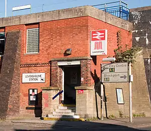
Levenshulme | |
|---|---|
 Front entrance to Levenshulme Railway Station | |
| General information | |
| Location | Levenshulme, Manchester England |
| Grid reference | SJ872941 |
| Managed by | Northern Trains |
| Transit authority | Transport for Greater Manchester |
| Platforms | 2 |
| Other information | |
| Station code | LVM |
| Classification | DfT category E |
| History | |
| Opened | ??? As Levenshulme and Burnage |
| Key dates | |
| 1 July 1910 | Station name changed to Levenshulme[1] |
| Passengers | |
| 2018/19 | |
| 2019/20 | |
| 2020/21 | |
| 2021/22 | |
| 2022/23 | |
| Location | |
| Notes | |
Passenger statistics from the Office of Rail and Road | |
Levenshulme railway station is in Levenshulme, Manchester, England. The station is 3.1 miles (5 km) south east of Manchester Piccadilly towards Stockport.
Four tracks go through the station, with the centre tracks used by fast trains and the outer by stopping trains.
Services
.jpg.webp)
As of December 2022, there are four trains per hour from Levenshulme in each direction during off-peak weekday hours and all day Saturdays.[2] All northbound services run to Manchester Piccadilly. Southbound, 1 train per hour runs to each of Alderley Edge, Crewe, Hazel Grove and Buxton.
On Sundays, the service is reduced to 1 train per hour between Manchester Piccadilly and Buxton.
| Preceding station | Following station | |||
|---|---|---|---|---|
| Northern Trains Monday to Saturday | ||||
| Northern Trains |
Signage
As well as English, the platform signs give the station name in Irish and Urdu, reflecting the immigrant communities from Ireland and Pakistan which live in the area.[3]
References
- ↑ "Minute No. 6359". Minutes of Meeting of the Superintendents' Conference (Report). London: Railway Clearing House. 2 July 1910. (Unpublished).
- ↑ Table 84 & 86 National Rail timetable, December 2022
- ↑ Railway Codes, 18 June 2019
Further reading
External links
- Train times and station information for Levenshulme railway station from National Rail
- Voices - Friends of Levenshulme station BBC Where I Live Manchester website
Manchester Lines South | |||||||||||||||||||||||||||||||||||||||||||||||||||||||||||||||||||||||||||||||||||||||||||||||||||||||||||||||||||||||||||||||||||||||||||||||||||||||||||||||||||||||||||||||||||||||||||||||||||||||||||||||||||||||||||||
|---|---|---|---|---|---|---|---|---|---|---|---|---|---|---|---|---|---|---|---|---|---|---|---|---|---|---|---|---|---|---|---|---|---|---|---|---|---|---|---|---|---|---|---|---|---|---|---|---|---|---|---|---|---|---|---|---|---|---|---|---|---|---|---|---|---|---|---|---|---|---|---|---|---|---|---|---|---|---|---|---|---|---|---|---|---|---|---|---|---|---|---|---|---|---|---|---|---|---|---|---|---|---|---|---|---|---|---|---|---|---|---|---|---|---|---|---|---|---|---|---|---|---|---|---|---|---|---|---|---|---|---|---|---|---|---|---|---|---|---|---|---|---|---|---|---|---|---|---|---|---|---|---|---|---|---|---|---|---|---|---|---|---|---|---|---|---|---|---|---|---|---|---|---|---|---|---|---|---|---|---|---|---|---|---|---|---|---|---|---|---|---|---|---|---|---|---|---|---|---|---|---|---|---|---|---|---|---|---|---|---|---|---|---|---|---|---|---|---|---|---|---|
| |||||||||||||||||||||||||||||||||||||||||||||||||||||||||||||||||||||||||||||||||||||||||||||||||||||||||||||||||||||||||||||||||||||||||||||||||||||||||||||||||||||||||||||||||||||||||||||||||||||||||||||||||||||||||||||
53°26′40″N 2°11′34″W / 53.44444°N 2.19278°W