Les Mayons | |
|---|---|
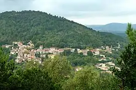 A general view of Les Mayons | |
.svg.png.webp) Coat of arms | |
Location of Les Mayons | |
 Les Mayons  Les Mayons | |
| Coordinates: 43°18′50″N 6°21′31″E / 43.3139°N 6.3586°E | |
| Country | France |
| Region | Provence-Alpes-Côte d'Azur |
| Department | Var |
| Arrondissement | Brignoles |
| Canton | Le Luc |
| Intercommunality | Cœur du Var |
| Government | |
| • Mayor (2020–2026) | Michel Mondani[1] |
| Area 1 | 28.86 km2 (11.14 sq mi) |
| Population | 629 |
| • Density | 22/km2 (56/sq mi) |
| Time zone | UTC+01:00 (CET) |
| • Summer (DST) | UTC+02:00 (CEST) |
| INSEE/Postal code | 83075 /83340 |
| Elevation | 79–742 m (259–2,434 ft) (avg. 194 m or 636 ft) |
| 1 French Land Register data, which excludes lakes, ponds, glaciers > 1 km2 (0.386 sq mi or 247 acres) and river estuaries. | |
Les Mayons (French pronunciation: [le majɔ̃]; Occitan: Lei Maions) is a commune in the Var department in the Provence-Alpes-Côte d'Azur region in southeastern France.
It lies approximately 30 km from St Tropez and 10 km from Le Luc.
See also
References
- ↑ "Répertoire national des élus: les maires" (in French). data.gouv.fr, Plateforme ouverte des données publiques françaises. 13 September 2022.
- ↑ "Populations légales 2021". The National Institute of Statistics and Economic Studies. 28 December 2023.
Wikimedia Commons has media related to Les Mayons.
This article is issued from Wikipedia. The text is licensed under Creative Commons - Attribution - Sharealike. Additional terms may apply for the media files.