| Lampman Hill | |
|---|---|
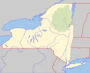 Lampman Hill Location of Lampman Hill within New York  Lampman Hill Lampman Hill (the United States) | |
| Highest point | |
| Elevation | 262 feet (80 m) |
| Coordinates | 42°20′27″N 73°47′41″W / 42.3409182°N 73.7948471°W[1] |
| Geography | |
| Location | SE of Coxsackie, New York, U.S. |
| Topo map | USGS Hudson North |
Lampman Hill is a mountain in Greene County, New York. It is located in the Catskill Mountains southeast of Coxsackie. High Rocks is located north-northwest, and Flint Mine Hill is located west-southwest of Lampman Hill.
References
This article is issued from Wikipedia. The text is licensed under Creative Commons - Attribution - Sharealike. Additional terms may apply for the media files.