Kuchyňa | |
|---|---|
Municipality | |
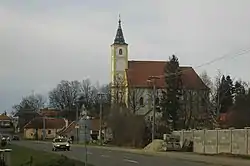 Saint Michael's church, Kuchyňa | |
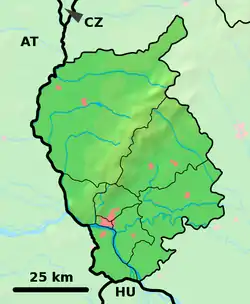 Kuchyňa Location of Kuchyňa in the Bratislava Region  Kuchyňa Kuchyňa (Slovakia) | |
| Coordinates: 48°24′N 17°10′E / 48.400°N 17.167°E | |
| Country | Slovakia |
| Region | Bratislava |
| District | Malacky |
| Area | |
| • Total | 45.13[1] km2 (17.42[1] sq mi) |
| Elevation | 253[2] m (830[2] ft) |
| Population (2021) | |
| • Total | 1,788[3] |
| Postal code | 900 52[2] |
| Area code | +421 34[2] |
| Car plate | MA |
| Website | obeckuchyna.sk |
Kuchyňa (Hungarian: Konyha, lit. 'Kitchen') is a municipality in the Malacky District in the Bratislava Region of western Slovakia close to the town of Malacky, north-west of Slovakia's capital Bratislava. Nearby castle ruins of Kuchyňa Castle bear the name of the municipality.
The Kuchyňa airbase, often used by the US Air Force for training purposes, is located approximately 18 kilometers east of the city of Malacky.
See also
References
- 1 2 "Hustota obyvateľstva - obce [om7014rr_ukaz: Rozloha (Štvorcový meter)]". www.statistics.sk (in Slovak). Statistical Office of the Slovak Republic. 2022-03-31. Retrieved 2022-03-31.
- 1 2 3 4 "Základná charakteristika". www.statistics.sk (in Slovak). Statistical Office of the Slovak Republic. 2015-04-17. Retrieved 2022-03-31.
- ↑ "Počet obyvateľov podľa pohlavia - obce (ročne)". www.statistics.sk (in Slovak). Statistical Office of the Slovak Republic. 2022-03-31. Retrieved 2022-03-31.
External links
![]() Media related to Kuchyňa at Wikimedia Commons
Media related to Kuchyňa at Wikimedia Commons
- Official page
- https://web.archive.org/web/20070513023228/http://www.statistics.sk/mosmis/eng/run.html
This article is issued from Wikipedia. The text is licensed under Creative Commons - Attribution - Sharealike. Additional terms may apply for the media files.