| Kompsatos | |
|---|---|
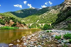 The river with the Polyanthos Bridge | |
| Native name | Κομψάτος (Greek) |
| Location | |
| Country | Greece |
| Region | Western Thrace |
| Physical characteristics | |
| Source | |
| • location | Rhodope Mountains |
| • coordinates | 41°20′53″N 24°59′5″E / 41.34806°N 24.98472°E |
| Mouth | |
• location | Lake Vistonida |
• coordinates | 41°3′31″N 25°7′9″E / 41.05861°N 25.11917°E |
| Length | 68 km (42 mi) |
| Basin size | 596 km2 (230 sq mi) |
The Kompsatos (Greek: Κομψάτος, Bulgarian: Сушица, Sushitsa), also called the Kouroú (Κουρο, Kurú) is a river flowing in Western Thrace, Greece. Its length is 68 kilometers. Its drainage basin is 596 km2 (230 sq mi).[1] The river originates from the Rhodope Mountains and flows into Lake Vistonida.[2][3]
References
- ↑ "Preliminary Flood Risk Assessment" (in Greek). Ministry of Environment, Energy and Climate Change. p. 91. Archived from the original on 15 February 2020.
- ↑ Avramea, Anna (1994). Thrace. Idea Advertising-Marketing SA. p. 355. ISBN 9608560918.
- ↑ Gerakēs, P. A. (1992). Conservation and Management of Greek Wetlands: Proceedings of a Workshop on Greek Wetlands, Thessaloniki, Greece, 17-21 April, 1989. The IUCN Wetlands Programme, 3. The IUCN conservation library. IUCN. p. 333. ISBN 283170104X.
This article is issued from Wikipedia. The text is licensed under Creative Commons - Attribution - Sharealike. Additional terms may apply for the media files.