Kojatín | |
|---|---|
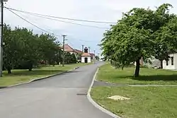 Main street | |
 Kojatín Location in the Czech Republic | |
| Coordinates: 49°14′34″N 16°0′37″E / 49.24278°N 16.01028°E | |
| Country | |
| Region | Vysočina |
| District | Třebíč |
| First mentioned | 1104 |
| Area | |
| • Total | 4.48 km2 (1.73 sq mi) |
| Elevation | 470 m (1,540 ft) |
| Population (2023-01-01)[1] | |
| • Total | 96 |
| • Density | 21/km2 (55/sq mi) |
| Time zone | UTC+1 (CET) |
| • Summer (DST) | UTC+2 (CEST) |
| Postal code | 675 03 |
| Website | www |
Kojatín is a municipality and village in Třebíč District in the Vysočina Region of the Czech Republic. It has about 100 inhabitants.
Kojatín lies approximately 11 kilometres (7 mi) east of Třebíč, 36 km (22 mi) south-east of Jihlava, and 149 km (93 mi) south-east of Prague.
References
Wikimedia Commons has media related to Kojatín.
This article is issued from Wikipedia. The text is licensed under Creative Commons - Attribution - Sharealike. Additional terms may apply for the media files.