 | |||||||||||
| General information | |||||||||||
| Location | Kinning Park, Glasgow Scotland | ||||||||||
| Coordinates | 55°51′03″N 4°17′17″W / 55.85083°N 4.28806°W | ||||||||||
| Operated by | SPT | ||||||||||
| Platforms | 2 | ||||||||||
| Construction | |||||||||||
| Structure type | underground | ||||||||||
| Accessible | No | ||||||||||
| Other information | |||||||||||
| Fare zone | G | ||||||||||
| History | |||||||||||
| Opened | 14 December 1896 | ||||||||||
| Passengers | |||||||||||
| 2018 | 0.655 million annually[1] | ||||||||||
| Services | |||||||||||
| |||||||||||
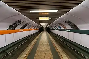
Kinning Park subway station serves the Kinning Park area of Glasgow, Scotland. However, to reach Kinning Park, a footbridge is provided across the M8.
It was opened in 1896 and comprehensively modernised in 1977–1980. The station retains its original island platform configuration.
Kinning Park station is the shallowest in the Subway system.
The station is lightly used and recorded only 240,000 boardings in the 12 months ending March 2005.
New ticket barriers came into operation on 10 July 2013.
Past passenger numbers
- 2004/05: 0.240 million annually
- 2011/12: 0.237 million annually[2]
References
- ↑ "Request for some usage statistics". Strathclyde Partnership for Transport. 11 January 2019. Archived from the original on 1 March 2019. Retrieved 28 February 2019 – via WhatDoTheyKnow.
- ↑ "Freedom of Information request: Subway station patronage - 1 April 2011 to 31 March 2012". Strathclyde Partnership for Transport. 18 December 2012. Archived from the original on 9 February 2019. Retrieved 9 February 2019 – via WhatDoTheyKnow.
This article is issued from Wikipedia. The text is licensed under Creative Commons - Attribution - Sharealike. Additional terms may apply for the media files.