| Kings Beach Caloundra, Queensland | |||||||||||||||
|---|---|---|---|---|---|---|---|---|---|---|---|---|---|---|---|
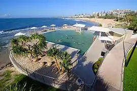
 Pool at Kings Beach | |||||||||||||||
 Kings Beach | |||||||||||||||
| Coordinates | 26°48′07″S 153°08′37″E / 26.8019°S 153.1436°E | ||||||||||||||
| Population | 2,788 (2016 census)[1] | ||||||||||||||
| • Density | 4,600/km2 (12,000/sq mi) | ||||||||||||||
| Postcode(s) | 4551 | ||||||||||||||
| Area | 0.6 km2 (0.2 sq mi) | ||||||||||||||
| Time zone | AEST (UTC+10:00) | ||||||||||||||
| Location |
| ||||||||||||||
| LGA(s) | Sunshine Coast Region | ||||||||||||||
| County | Canning | ||||||||||||||
| Parish | Bribie | ||||||||||||||
| State electorate(s) | Caloundra | ||||||||||||||
| Federal division(s) | Fisher | ||||||||||||||
| |||||||||||||||
Kings Beach is a coastal suburb of Caloundra in the Sunshine Coast Region, Queensland, Australia, located directly east of Caloundra CBD.[2] In the 2016 census, Kings Beach had a population of 2,788 people.[1]
Geography
The suburb faces the Coral Sea from its north-east to its south, with a sandy beach to the south and south-east and a rocky headland to the north and north-east. The suburb locality is quite hilly ranging from the beach at sea level to the north-west of the locality at over 40 metres (130 ft) and the headland is at 20 metres (66 ft).[3]
The suburb has medium density housing, both permanently occupied and for holiday accommodation. The commercial development is mostly along the beach front where there are also amenities for beach visitors (showers and toilets). There is parkland along the beach front and a walking path around the headland.[3]
History
Kings Beach was named after the King family, the first European residents in the area. After living at Moffat Head in James Moffat's home for a while, they moved to the Kings Beach area in 1893.[4]
St Andrew's Anglican Church was dedicated on Sunday 22 January 1939 by Archbishop William Wand. The construction of the church had been strongly encouraged by Wand who holidayed at Caloundra with his friend Queensland Governor Leslie Wilson. The Governor also attended the church's dedication.[5] On 10 December 1966 the foundation stone of the new church was laid Archbishop Philip Strong, who opened and dedicated the new church on 8 December 1967. The new church was consecrated in 1974.[6][7]
Within Kings Beach's boundaries is Wickham Head, a headland off which the hospital ship AHS Centaur is believed to have been sunk by Japanese submarines in 1943.[8]
In the 2016 census, Kings Beach had a population of 2,788 people.[1]
Heritage listings
Kings Beach has a number of heritage-listed sites, including:
- 6 Arthur Street and 3 Canberra Terrace: Caloundra Lighthouses[9]
- Ormonde Terrace: Kings Beach Bathing Pavilion[10]
Education
There are no schools in Kings Beach, but there are primary and secondary schools in neighbouring Caloundra.[3]
Amenities
St Andrew's Anglican Church is at 46 Upper Gay Terrace, Kings Beach (26°48′12″S 153°08′17″E / 26.8032°S 153.1381°E).[11]
References
- 1 2 3 Australian Bureau of Statistics (27 June 2017). "Kings Beach (SSC)". 2016 Census QuickStats. Retrieved 20 October 2018.
- ↑ "Kings Beach – suburb in Sunshine Coast Region (entry 48704)". Queensland Place Names. Queensland Government. Retrieved 27 January 2020.
- 1 2 3 "Queensland Globe". State of Queensland. Retrieved 25 May 2019.
- ↑ Caloundra – Local Beach Guide Archived 12 December 2006 at the Wayback Machine 19 December 2006
- ↑ "Dedication of Church at Caloundra". The Telegraph. Queensland, Australia. 23 January 1939. p. 3 (CITY FINAL LAST MINUTE NEWS). Retrieved 25 September 2020 – via National Library of Australia.
- ↑ "Year Book" (PDF). Anglican Archdiocese of Brisbane. 2019. p. 137. Archived (PDF) from the original on 15 September 2020. Retrieved 15 September 2020.
- ↑ "Parish profile" (PDF). The Anglican Parish of Caloundra-Glasshouse Country. p. 3. Retrieved 25 September 2020.
- ↑ Dunn, Peter (2006). "Sinking of the hospital ship "Centaur" by Japanese submarine I-177 on 14 May 1943 off the Queensland coast east of Brisbane". Retrieved 21 June 2011.
- ↑ "Caloundra Lighthouses (entry 602746)". Queensland Heritage Register. Queensland Heritage Council. Retrieved 14 July 2013.
- ↑ "Kings Beach Bathing Pavilion (entry 601513)". Queensland Heritage Register. Queensland Heritage Council. Retrieved 14 July 2013.
- ↑ "Contact Details". St Andrew's (Caloundra & Glasshouse Country). Retrieved 24 September 2020.
External links
- "Kings Beach". Queensland Places. Centre for the Government of Queensland, University of Queensland.