Karimun Regency
Kabupaten Karimun | |
|---|---|
 Seal | |
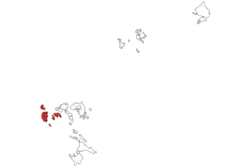
 Location within Riau Islands | |
| Coordinates: 1°3′0″N 103°22′0″E / 1.05000°N 103.36667°E | |
| Country | Indonesia |
| Province | Riau Islands |
| Regency seat | Tanjung Balai Karimun |
| Government | |
| • Regent | Aunur Rafiq |
| • Vice Regant | Anwar Hasyim |
| Area | |
| • Total | 1,524.00 km2 (588.42 sq mi) |
| Population (2023 estimate)[1] | |
| • Total | 268,713 |
| • Density | 180/km2 (460/sq mi) |
| Time zone | UTC+7 (Indonesia Western Time) |
| Area code | (+62) 777 |
| Website | karimunkab.go.id |
The Karimun Regency is located in the Riau Islands Province, Indonesia. Besides the central island of Great Karimun, the regency also includes the islands of Kundur and over 240 smaller islands. The district covers a land area of 1,524 km2 and a sea area of 6,460 km2, and its population was 212,561 at the 2010 census[2] and 253,457 at the 2020 census;[3] the official estimate as at mid 2022 was 266,177.[1]
Administrative districts
The regency was formerly divided into nine districts (kecamatan), but on 11 June 2012 a further three districts were added – Ungar (from part of Kundur District), Belat (from part of Kundur Utara District), and Meral Barat (out of the western part of Meral District). The twelve districts are tabulated below with their areas and populations at the 2010 [2] and 2020 censuses,[3] together with the official estimates as at mid 2022.[1] The table also includes the locations of the district administrative centres, the number of administrative villages (rural desa and urban kelurahan) and the number of islands within each district, and their postal codes. In 2022 two additional districts were created – Sugie Besar, cut out of Moro District, and Selat Gelam, cut out of Buru District – but no separate figures are yet available for these new districts.
Great Karimun Island (Pulau Karimunbesar) comprises the districts of Tebing, Meral, Meral Barat and Karimun (the former northern part of Karimun District, which forms Tanjung Balai town). Kundur Island is a group of islands comprising the districts of Kundur, Ungar, Kundur Barat, Kundur Utara, Belat, Buru and Selat Gelam (the former southern part of Karimun District – Parit desa and Tulang desa ).
| Name of District (kecamatan) | Area in km2 | Pop'n Census 2010 | Pop'n Census 2020 | Pop'n Estimate mid 2022 | Admin centre | No. of Villages | No. of islands | Post Code |
|---|---|---|---|---|---|---|---|---|
| Moro (a) | 447.92 | 17,512 | 18,640 | 19,141 | Moro | 12 (b) | 86 | 29663 |
| Durai (c) | 62.98 | 5,821 | 6,026 | 6,155 | Telaga Tujuh | 4 | 47 | 29665 |
| Kundur | 83.74 | 33,878 | 30,490 | 31,818 | Tanjung Batu Kota | 6 (d) | 24 | 29662 |
| Kundur Utara (North Kundur) | 245.65 | 17,066 | 12,653 | 13,383 | Tanjung Berlian Kota | 5 (e) | 23 | 29662 |
| Kundur Barat (West Kundur) | 189.82 | 16,146 | 18,854 | 19,711 | Sawang | 5 (e) | 12 | 29662 |
| Ungar | 55.53 | (f) | 5,660 | 6,069 | Sei Buluh | 4 (e) | 26 | 29669 |
| Belat | 109.34 | (g) | 6,346 | 6,830 | Sebele | 6 | 22 | 29660 |
| Karimun | 59.76 | 42,591 | 51,353 | 54,018 | Tanjung Balai Kota | 6 (h) | 24 | 29661 |
| Buru (i) | 73.40 | 8,967 | 9,770 | 10,078 | Buru | 4 (b) | 7 | 29664 |
| Meral | 57.85 | 44,627 | 48,964 | 52,015 | Meral Kota | 6 (h) | 4 | 29666 |
| Tebing | 76.35 | 25,943 | 29,721 | 30,957 | Tebing | 6 (j) | 2 | 29668 |
| Meral Barat (West Meral) | 61.55 | (k) | 14,980 | 16,002 | Darussalam | 4 (b) | 22 | 29667 |
| Totals | 1,524.00 | 212,561 | 253,457 | 266,177 | 71 | 256 |
Note: (a) a group of islands east of Kundur, situated to the southwest of Batam Island; the largest islands are Sugie, Citlim and Moro. In 2022 an extra district was cut out of Moro District; this Sugie Besar District incorporates 7 of the 10 desa formerly in Moro District.
(b) includes 2 kelurahan. (c) a group of islands situated to the southeast of Kundur Island. (d) includes 3 kelurahan. (e) includes 1 kelurahan. (f) the 2010 Census figure for the new Ungar District is included with that for Kundur District, from which the new district was cut out on 11 June 2012.
(g) the 2010 Census figure for the new Belat District is included with that for Kundur Utara District, from which the new district was cut out on 11 June 2012.
(h) Karimun District and Meral District each comprise 6 kelurahan (and no desa) (i) In 2022 an extra district was cut out of Buru District; this Selat Gelam District incorporates 3 of the 5 ;desa formerly in Buru District. (j) Tebing District comprises 5 kelurahan (plus 1 desa.)
(k) the 2010 Census figure for the new Meral Barat District is included with that for Meral District, from which the new district was cut out on 11 June 2012.
Demographics
Religion
Islam is the dominant religion in the regency, with 84.09% of the total population identifying as Muslim. Other religions are Buddhism, which forms 10.68% of the total population, Christianity, which forms 4.85% of the total population, Hinduism, which forms 0.01% of the total population, and Confucianism, which forms 0.37% of the total population.
References
External links
- Official website (in Indonesian)
See also
- Great Karimun, the main island in the regency
- Little Karimun
- Kundur Island

