Kalamb | |
|---|---|
Town | |
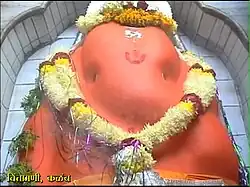
 Shree Chintamani of Kalamb | |
 Kalamb Location in Maharashtra, India  Kalamb Kalamb (India) | |
| Coordinates: 20°26′40″N 78°19′32″E / 20.44444°N 78.32556°E | |
| Country | |
| State | Maharashtra |
| District | Yavatmal |
| Founded by | Aurangzeb alamgir |
| Government | |
| • Type | Nagar panchayat |
| • Body | Nagar panchayat kalamb |
| Area | |
| • Total | 20 km2 (8 sq mi) |
| Population (2011) | |
| • Total | 25,000 |
| • Density | 1,300/km2 (3,200/sq mi) |
| Language | |
| • Official | Marathi |
| Time zone | UTC+5:30 (IST) |
| PIN | 445401 |
| Telephone code | 07201 |
| Vehicle registration | MH-29 |
| Lok Sabha constituency | Yavatmal-Washim |
| Vidhan Sabha constituency | Ralegaon |
Kalamb is a town in the Yavatmal district of Maharashtra state in India. It is famous for its temple devoted to the Hindu god Ganesha, and Muslim scholar Baba Basuri Wale.
Landmarks
Kalamb's temple is known as Shree Chintamani Temple, based on another name for Ganesh that emphasizes the belief that praying to him can remove worries ('Chinta' means worry in Sanskrit and in local Marathi language). It belongs to Vidarbha Ashtavinayak, one of the eight Ganapati kshetras in Vidarbha. It is one of the 21 kshetras of Ganesh throughout India. An annual fair of Shree Chintamani is held here.
Geography
The Chakravati River flows through Kalamb city. It has an average elevation of 283 metres.
History
The village was an important revenue assessment center under the Mughal Empire in early seventeenth century as the capital of a Sarkar (sub-unit of a Mughal Subah) of the same name, earlier spelled as 'Kalam'.[1]
Demographics
Kalamb is administrative center of a Taluka (sub-district) also called Kalamb. The Taluka had a population of about 103 thousand in 2011, and consisted of 143 villages.[2] It is part of the Vidarbha region. As of 2011, 86.78% of the population was Hindu, 8.89% was Buddhist, and 3.69% was Muslim, with all other religious minorities making up less than 1% of the population.[2]
Transportation
Kalamb is on the Yavatmal-Nagpur highway. The nearest railway station is Dhamangaon and Wardha which is on the Mumbai-Nagpur Expressway.
A New Kalamb Railway Station is being under Constructed on New Braud Gauge Wardha Yavatmal Nanded line.The Station is 3 km Away from Kalamb near Kamathwada.
References
- ↑ Schwartzberg, Joseph E. (1978). The Historic Atlas of South Asia. University of Chicago Press. p. 45., Plate VI.A.2
- 1 2 "Kalamb Taluka Population Yavatmal, Maharashtra, List of Villages & Towns in Kalamb Taluka". Censusindia2011.com. Retrieved 12 April 2023.
.svg.png.webp)