Königshain | |
|---|---|
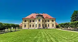 Königshain Castle | |
 Coat of arms | |
Location of Königshain within Görlitz district 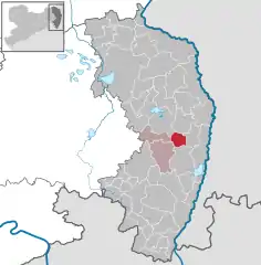 | |
 Königshain  Königshain | |
| Coordinates: 51°11′N 14°52′E / 51.183°N 14.867°E | |
| Country | Germany |
| State | Saxony |
| District | Görlitz |
| Municipal assoc. | Reichenbach |
| Government | |
| • Mayor (2022–29) | Maik Wobst[1] |
| Area | |
| • Total | 19.52 km2 (7.54 sq mi) |
| Elevation | 233 m (764 ft) |
| Population (2021-12-31)[2] | |
| • Total | 1,163 |
| • Density | 60/km2 (150/sq mi) |
| Time zone | UTC+01:00 (CET) |
| • Summer (DST) | UTC+02:00 (CEST) |
| Postal codes | 02829 |
| Dialling codes | 035826 |
| Vehicle registration | GR, LÖB, NOL, NY, WSW, ZI |
| Website | www.koenigshain.com |
Königshain (Upper Sorbian: Kralowski haj, pronounced [ˈkʁalɔfskʲi ˈhaj]) is a municipality in the district Görlitz, Saxony, Germany.
References
- ↑ Gewählte Bürgermeisterinnen und Bürgermeister im Freistaat Sachsen, Stand: 17. Juli 2022, Statistisches Landesamt des Freistaates Sachsen.
- ↑ "Bevölkerung des Freistaates Sachsen nach Gemeinden am 31. Dezember 2021" (XLS) (in German). Statistisches Landesamt des Freistaates Sachsen. 2022.
This article is issued from Wikipedia. The text is licensed under Creative Commons - Attribution - Sharealike. Additional terms may apply for the media files.