Jablůnka | |
|---|---|
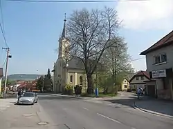 Evangelical church | |
 Flag  Coat of arms | |
 Jablůnka Location in the Czech Republic | |
| Coordinates: 49°23′0″N 17°57′0″E / 49.38333°N 17.95000°E | |
| Country | |
| Region | Zlín |
| District | Vsetín |
| First mentioned | 1505 |
| Area | |
| • Total | 8.21 km2 (3.17 sq mi) |
| Elevation | 324 m (1,063 ft) |
| Population (2023-01-01)[1] | |
| • Total | 2,062 |
| • Density | 250/km2 (650/sq mi) |
| Time zone | UTC+1 (CET) |
| • Summer (DST) | UTC+2 (CEST) |
| Postal code | 756 23 |
| Website | www |
Jablůnka is a municipality and village in Vsetín District in the Zlín Region of the Czech Republic. It has about 2,100 inhabitants.
Geography
Jablůnka is located about 6 kilometres (4 mi) north of Vsetín and 27 km (17 mi) northeast of Zlín. It lies in the Hostýn-Vsetín Mountains. The highest point is at 569 m (1,867 ft) above sea level. The municipality is situated on the right bank of the Vsetínská Bečva river.
References
External links
Wikimedia Commons has media related to Jablůnka.
This article is issued from Wikipedia. The text is licensed under Creative Commons - Attribution - Sharealike. Additional terms may apply for the media files.