Holedeč | |
|---|---|
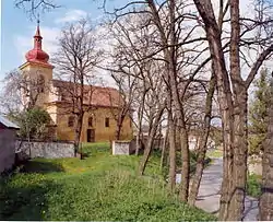 Church of Saint Bartholomew in Holedeček | |
 Flag  Coat of arms | |
 Holedeč Location in the Czech Republic | |
| Coordinates: 50°16′39″N 13°33′47″E / 50.27750°N 13.56306°E | |
| Country | |
| Region | Ústí nad Labem |
| District | Louny |
| First mentioned | 1318 |
| Area | |
| • Total | 18.56 km2 (7.17 sq mi) |
| Elevation | 219 m (719 ft) |
| Population (2023-01-01)[1] | |
| • Total | 630 |
| • Density | 34/km2 (88/sq mi) |
| Time zone | UTC+1 (CET) |
| • Summer (DST) | UTC+2 (CEST) |
| Postal code | 438 01 |
| Website | www |
Holedeč is a municipality and village in Louny District in the Ústí nad Labem Region of the Czech Republic. It has about 600 inhabitants.
Holedeč lies approximately 20 kilometres (12 mi) south-west of Louny, 56 km (35 mi) south-west of Ústí nad Labem, and 64 km (40 mi) west of Prague.
Administrative parts
Villages of Holedeček, Stránky and Veletice are administrative parts of Holedeč.
References
Wikimedia Commons has media related to Holedeč.
This article is issued from Wikipedia. The text is licensed under Creative Commons - Attribution - Sharealike. Additional terms may apply for the media files.