 | |
|---|---|
| Route information | |
| Length | 476.5 km[1] (296.1 mi) |
| Existed | 1972[2]–present |
| Major junctions | |
| From | Niigata-Chūō Junction in Niigata, Niigata |
| To | Maibara Junction in Maibara, Shiga |
| Location | |
| Country | Japan |
| Major cities | Nagaoka, Jōetsu, Uozu, Toyama, Kanazawa, Komatsu, Fukui, Sabae, Echizen, Tsuruga, Nagahama |
| Highway system | |
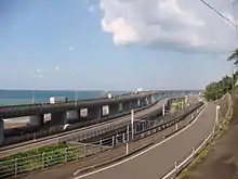
Left:Hokuriku Expressway
Center:National Route 8 and JR Hokuriku Main Line
Right: Niigata Prefectural Road Route 525
The Hokuriku Expressway (北陸自動車道, Hokuriku Jidōsha-dō), (abbreviated as Hokuriku Expwy (北陸道, Hokurikudō), is a 4-laned national expressway in Japan. It is owned and managed by East Nippon Expressway Company and Central Nippon Expressway Company.
Overview
The first section was opened in 1972 by Japan Highway Public Corporation and construction proceeded in stages until the entire route was completed in 1988.[3] On October 1, 2005, all national expressways were privatized[4] and management of the Hokuriku Expressway was divided between the East and Central Nippon Expressway Companies.[5]
The route serves the Hokuriku region on the north central coast of Honshū, Japan's largest island. For most of its length it parallels National Route 8 and the Hokuriku Main Line of West Japan Railway Company.
Although the route officially originates in Niigata and terminates at Maibara, exit numbers and kilometer markings originate from Maibara.
Features
Around Tsuruga Interchange, the south-bound lanes cross over the north-bound lanes and diverges drastically. The expressway rejoins normally at a point near Suizu Parking Area.
There are 14 tunnels between Kinomoto Interchange and Takefu Interchange (two of which are longer than 2,000 m (6,600 ft)), and 26 tunnels between Asahi Interchange and Jōetsu Interchange (eight of which are longer than 2,000 m (6,600 ft)).
List of interchanges and features
- IC - interchange, SIC - smart interchange, JCT - junction, SA - service area, PA - parking area, BS - bus stop, TN - tunnel, CB - snow chains
| No. | Name | Connections | Dist. from Maibara |
Bus Stop | Notes | Location | |
|---|---|---|---|---|---|---|---|
| 27-1 | Maibara JCT | 0.0 | Maibara | Shiga | |||
| 1 | Maibara IC | 0.6 | |||||
| PA | Kanda PA | 4.7 | X | Nagahama | |||
| 2 | Nagahama IC | Pref. Route 37 (Nakayama Higashi Kōsaka Route) | 9.6 | X | |||
| BS | Torahime Bus Stop | X | Closed | ||||
| 2-1/BS | Odanijō SIC Kohoku Bus Stop |
Pref. Route 263 (Yōno Torahime Nagahama Route) (South-bound) Pref. Route 265 (Gōno Kohoku Route) (North-bound) |
16.4 | X | Bus Stop closed | ||
| BS | Takatsuki Bus Stop | X | Closed | ||||
| 3 | Kinomoto IC | 23.4 | X | ||||
| SA | Shizugatake SA | 25.6 | |||||
| BS/CB | Yogo Bus Stop Yogo Chain Base |
X | Bus Stop closed | ||||
| BS/CB | Yogo-kita Bus Stop Yogo-kita Chain Base |
X | Bus Stop closed | ||||
| PA | Tone PA | 38.5 | X | Tsuruga | Fukui | ||
| 3-1 | Tsuruga JCT | 45.4 | |||||
| 4 | Tsuruga IC | 46.6 | ○ | ||||
| BS/CB | Tajiri (South-bound) Akihara (North-bound) |
X | Bus Stop closed | ||||
| PA | Suizu PA | 57.9 | X | ||||
| 5 | Imajō IC | 68.2 | X | Minamiechizen | |||
| SA/ 5-1 | Nanjō SA/SIC | Pref. Route 203 (Ikeda Nanjō Route) | 71.4 72.1 |
X | North-bound South-bound | ||
| 6 | Takefu IC | Pref. Route 262 (Takefu Inter Higashi Route) Pref. Route 40 (Takefu Inter Route) |
80.6 | ○ | Echizen | ||
| 7 | Sabae IC | Pref. Route 105 (Sabae Imadate Route) Pref. Route 39 (Sabae Inter Route) |
86.2 | ○ | Sabae | ||
| PA | Kitasabae PA | 88.6 | |||||
| 8 | Fukui IC | 97.2 | ○ | Fukui | |||
| 9 | Fukui-kita IC/JCT | 103.6 | ○ | ||||
| 10 | Maruoka IC | Pref. Route 38 (Maruoka Inter Route) | 110.4 | ○ | Sakai | ||
| PA | Onagatani PA | 113.4 | |||||
| 11 | Kanazu IC | Pref. Route 37 (Kanazu Inter Route) Pref. Route 124 (Ushinoya Teishajō Route) |
120.9 | Awara | |||
| 12 | Kaga IC | Pref. Route 61 (Kaga Inter Route) | 128.2 | Kaga | Ishikawa | ||
| SA | Amagozen SA | 136.6 136.9 |
○ | South-bound North-bound | |||
| 13 | Katayamazu IC | Pref. Route 20 (Komatsu Kaga Route) | 140.7 | ||||
| PA/ 13-1 | Ataka PA/SIC | Pref. Route 20 (Komatsu Kaga Route) | 144.7 | SIC: Maibara-bound Open 06:00-22:00 |
Komatsu | ||
| 14 | Komatsu IC | Pref. Route 25 (Kanazawa Mikawa Komatsu Route) | 149.3 | ○ | |||
| 14-1 | Nomineagari SIC | 155.4 | Nomi | ||||
| 15 | Mikawa IC | Pref. Route 25 (Kanazawa Mikawa Komatsu Route) Pref. Route 58 (Tsurugi Mikawa Inter Route) |
160.3 | Hakusan | |||
| PA/ 15-1 | Tokumitsu PA/SIC | Pref. Route 25 (Kanazawa Mikawa Komatsu Route) | 164.6 | ○ | Highway Oasis | ||
| BS | Mattō Bus Stop | 169.6 | X | closed by replacement | |||
| 15-2 | Hakusan IC | Pref. Route 8 (Mattō Unoke Route) | 169.9 | ○ | incl. Mattō Bus Stop | ||
| 16 | Kanazawa-nishi IC | Pref. Route 197 (Jichūnishi Kanazawa Route) |
172.5 | Kanazawa | |||
| 17 | Kanazawa-higashi IC | 180.1 | |||||
| 17-1 | Kanazawa-morimoto IC | 183.4 | |||||
| PA | Fudōji PA | 184.7 | |||||
| 18 | Oyabe IC | Pref. Route 42 (Oyabe Fukumitsu Route) | 197.7 | Oyabe | Toyama | ||
| SA | Oyabegawa SA | 199.8 | |||||
| 19 | Oyabe-Tonami JCT | 203.1 | |||||
| Tonami | |||||||
| 20 | Tonami IC | 207.1 | |||||
| 20-1 | Takaoka-Tonami SIC | 212.9 | ○ | ||||
| PA | Takaoka PA | 216.1 | Takaoka | ||||
| 21 | Kosugi IC | 221.5 | Imizu | ||||
| PA | Kureha PA | 224.5 | |||||
| 21-1 | Toyama-nishi IC | Pref. Route 41 (Shinminato Hiraoka Route) | 226.6 | Toyama | |||
| 22 | Toyama IC | 234.1 | |||||
| 22-1/ PA | Nagaresugi PA/SIC | Pref. Route 56 (Toyama Kanjō Route) | 240.9 | ||||
| 23 | Tateyama IC | Pref. Route 3 (Toyama Tateyama Uozu Route) | 246.4 | Tateyama | |||
| Kamiichi SIC | Pref. Route 148 (Kamiichi Mizuhashi Route) | 250.6 | Opens in December 2020 | Kamiichi | |||
| 24 | Namerikawa IC | Pref. Route 51 (Minowa Namerikawa Inter Route) | 254.5 | ○ | Namerikawa | ||
| SA | Arisoumi SA | 258.2 | Maibara-bound | ||||
| 261.6 | Niigata-bound | Uozu | |||||
| 25 | Uozu IC | Pref. Route 52 (Ishigaki Uozu Inter Route) | 263.8 | ||||
| 26 | Kurobe IC | Pref. Route 53 (Wakaguri Ikuji Route) | 273.4 | ○ | Kurobe | ||
| 26-1/ PA | Nyūzen PA/SIC | Pref. Route 63 (Nyūzen Unazuki Route) | 277.9 | Nyūzen | |||
| 27 | Asahi IC | 282.1 | Asahi | ||||
| PA | Etchūsakai PA | 288.4 | |||||
| 28 | Oyashirazu IC | 299.3 | Itoigawa | Niigata | |||
| 29 | Itoigawa IC | 311.9 | |||||
| PA | Rendaiji PA | 313.5 | |||||
| BS | Hayakawa Bus Stop | 318.0 | ○ | ||||
| 30 | Nou IC | Pref. Route 246 (Nishitobiyama Nō Route) Pref. Route 88 (Nō Inter Route) |
326.5 | ○ | |||
| 31/SA | Nadachi Tanihama IC/ SA |
Pref. Route 87 (Nadachi Tanihama Inter Route) | 341.6 | ○ | Jōetsu | ||
| 31-1 | Jōetsu JCT | 351.4 | |||||
| BS | Kida Bus Stop | 353.4 | ○ | ||||
| 32 | Jōetsu IC | 355.8 | |||||
| BS | Kubiki Bus Stop | 360.7 | ○ | ||||
| 32-1/ PA | Ōgata PA/SIC | Pref. Route 77 (Jōetsu Kubiki Ōgata Route) | 365.3 | SIC: Open 06:00-22:00 | |||
| BS | Katamachi Bus Stop | 367.9 | ○ | ||||
| 33 | Kakizaki IC | 373.8 | ○ | ||||
| 34/SA | Yoneyama IC/ SA |
385.2 | SA: Niigata-bound | Kashiwazaki | |||
| SA | Yoneyama SA | 387.2 | Maibara-bound | ||||
| BS | Kamigata Bus Stop | 393.5 | ○ | ||||
| 35 | Kashiwazaki IC | 397.1 | |||||
| BS | Sochi Bus Stop | 402.8 | ○ | ||||
| PA | Kariwa PA | 405.8 | Kariwa | ||||
| 36 | Nishiyama IC | Pref. Route 23 (Kashiwazaki Takahama Horinouchi Route) Pref. Route 393 (Raihai Nagaoka Route) |
407.8 | ○ | Kashiwazaki | ||
| PA | Ōzumi PA | 414.9 | ○ | Nagaoka | |||
| 37 | Nagaoka JCT | 421.6 | |||||
| BS | Nagaoka-kita Bus Stop | 423.9 | ○ | ||||
| 38 | Nakanoshima-Mitsuke IC | 432.1 | |||||
| 38-1/ PA | Sakae PA/SIC | 441.5 | ○ | Sanjō | |||
| 39 | Sanjō-Tsubame IC | 447.4 | ○ | Tsubame | |||
| 40 | Maki-Katahigashi IC | Pref. Route 9 (Nagaoka Tochio Maki Route) |
457.7 | ○ | Nishikan-ku, Niigata | ||
| 40-1/ PA | Kurosaki PA/SIC | Pref. Route 44 (Niigata Tsubame Route) Pref. Route 46 (Niigata Chūō Kanjō Route) |
467.1 | SIC: Open 06:00-22:00 | Nishi-ku, Niigata | ||
| BS | Toppara Bus Stop | 471.0 | ○ | ||||
| 41 | Niigata-nishi IC | 473.0 | |||||
| 42 | Niigata-Chūō JCT | 476.5 | Kōnan-ku, Niigata | ||||
| Through to | |||||||
References
- ↑ Ministry of Land, Infrastructure and Transport, Kinki Regional Development Bureau. "Road Timetable" (in Japanese). Retrieved 2008-04-16.
{{cite web}}: CS1 maint: multiple names: authors list (link) - ↑ "Expressway Opening Dates" (in Japanese). Retrieved 2008-04-16.
- ↑ Ministry of Land, Infrastructure and Transport, Hokuriku Regional Development Bureau. "Oyashirazu Pia Park Profile" (in Japanese). Retrieved 2008-04-16.
{{cite web}}: CS1 maint: multiple names: authors list (link) - ↑ Mizutani, Fumitoshi; Uranishi, Shuji (2006). Privatization of the Japan Highway Public Corporation: Policy Assessment (PDF). 46th Congress for the European Regional Science Association. Volos, Greece. Retrieved 2008-04-11.
- ↑ "NEXCO-Central Business Outline" (PDF). Retrieved 2008-04-13.
External links
| National Expressways | |
|---|---|
| Toll Roads | |