 | ||||
|---|---|---|---|---|
| כביש 89 | ||||
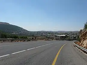
 Highway 89 at the eastern entrance to Hurfeish | ||||
| Route information | ||||
| Length | 58 km (36 mi) | |||
| Major junctions | ||||
| West end | Nahariya Junction | |||
| East end | Elifelet Interchange | |||
| Location | ||||
| Country | Israel | |||
| Highway system | ||||
| ||||
Highway 89 is a major east–west highway in the Upper Galilee and Western Galilee in northern Israel. It begins in the west in Nahariya and continues east to Ma'alot-Tarshiha, Safed, Hatzor HaGlilit and Rosh Pina, crossing the entire Galilee. It is 58 km long
The route begins in the west at Nahariya junction with Highway 4 and continues east past several moshavim, kibbutzim and villages until it reaches Ma'alot-Tarshiha. Afterward, the road continues to Meron mountain, where it turns south toward Safed and passes south of the city. It continues east toward its eastern terminus, a junction with Highway 90 at Elifelet
Junctions & Interchanges
| Km | Name | Type | Location | Intersecting routes |
|---|---|---|---|---|
| Nahariya Junction | Nahariya | |||
| — | Nahariya | HaGilead St. | ||
| — | Nahariya | HaNegev and HaGolan Streets | ||
| — | Nahariya | Yehiam Rd. | ||
| — | Nahariya | HaZeitim Rd. | ||
| (Entrance to Ben Ami) | Ben Ami, |
21st Battalion St. | ||
| Kabri Junction | Kabri | |||
| — | HaShayara Spring, Mateh Asher regional school |
Local road | ||
| Ga'aton Junction | Road 8833 | |||
| — | Armor Hill | Local road | ||
| (Entrance to Neve Ziv) | Neve Ziv | Local road | ||
| — | Mi'ilya | Local road | ||
| — | Mi'ilya | Local road | ||
| — | Me'ona | Road 8835 | ||
| — | Ma'alot-Tarshiha | Chaim Herzog Blvd. | ||
| — | Ma'alot-Tarshiha | Road 8835 | ||
| — | Ma'alot-Tarshiha | 43 Immigrants Blvd. | ||
| Yefe Nof Interchange | Ma'alot-Tarshiha | 43 Immigrants Blvd. | ||
| Tefen Junction | Ma'alot-Tarshiha | |||
| Hosen Junction | Hosen | |||
| (Entrance to Tzuriel) | Tzuriel | Local road | ||
| Elkosh Junction | Elkosh | Road 8944 | ||
| — | Hurfeish | Local road | ||
| Sultan Basha al-Atrash Square | Hurfeish | Local road | ||
| — | Hurfeish | Local road | ||
| — | Hurfeish | Local road | ||
| — | Hurfeish | Local road | ||
| — | Hurfeish | Local road | ||
| — | East of Hurfeish | Local road | ||
| — | Near Mount Meron | Local road | ||
| (Entrance to Sasa) | Sasa | Local road | ||
| — | Sasa | |||
| Hiram Junction | ||||
| (Entrance to Tziv'on) | Tziv'on | Local road | ||
| — | Jish | Local road | ||
| — | Jish | Local road | ||
| — | Jish | Local road | ||
| (Entrance to Kfar Hoshen) | Kfar Hoshen | Local road | ||
| (Entrance to Bar Yohai and Or HaGanuz) | Bar Yohai | Local road | ||
| Meron Junction | Meron | |||
| Ein Zeitim Junction | South of Ein Zeitim | |||
| — | Safed | Local road | ||
| (Entrance to Akbara) | Safed (Akbara neighborhood) | Local road | ||
| Elifelet Interchange | Elifelet |
See also
This article is issued from Wikipedia. The text is licensed under Creative Commons - Attribution - Sharealike. Additional terms may apply for the media files.