Hiawatha Township | |
|---|---|
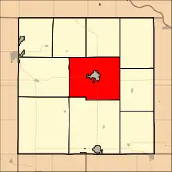 Location in Brown County | |
| Coordinates: 39°50′35″N 095°33′01″W / 39.84306°N 95.55028°W | |
| Country | United States |
| State | Kansas |
| County | Brown |
| Area | |
| • Total | 63.57 sq mi (164.64 km2) |
| • Land | 63.45 sq mi (164.34 km2) |
| • Water | 0.11 sq mi (0.29 km2) 0.18% |
| Elevation | 1,135 ft (346 m) |
| Population (2000) | |
| • Total | 739 |
| • Density | 11.6/sq mi (4.5/km2) |
| GNIS feature ID | 0472777 |
Hiawatha Township is a township in Brown County, Kansas, USA. As of the 2000 census, its population was 739.
Hiawatha Township was formed in 1872.[1]
Geography
Hiawatha Township covers an area of 63.57 square miles (164.6 km2) and contains one incorporated settlement, Hiawatha (the county seat). According to the USGS, it contains one cemetery, Mount Hope.
The stream of North Fork Wolf River runs through this township.
Transportation
Hiawatha Township contains two airports or landing strips: Davis Airfield and Hiawatha Municipal Airport.
References
External links
Municipalities and communities of Brown County, Kansas, United States | ||
|---|---|---|
| Cities | 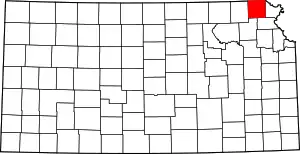 Map of Kansas highlighting Brown County | |
| Unincorporated communities | ||
| Indian reservations | ||
| Townships | ||
| Footnotes | †This community is designated a Census-Designated Place (CDP) by the United States Census Bureau. ‡This community also has portions in an adjacent county or counties. | |
This article is issued from Wikipedia. The text is licensed under Creative Commons - Attribution - Sharealike. Additional terms may apply for the media files.