Helperknapp | |
|---|---|
 | |
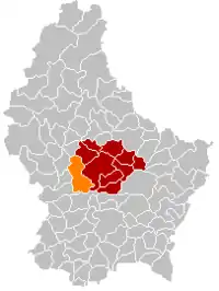 Map of Luxembourg with Helperknapp highlighted in orange, and the canton in dark red | |
| Coordinates: 49°43′2″N 6°0′38″E / 49.71722°N 6.01056°E | |
| Country | |
| Canton | Mersch |
| Area | |
| • Total | 37.61 km2 (14.52 sq mi) |
| • Rank | 16th of 102 |
| Highest elevation | 393 m (1,289 ft) |
| • Rank | 56th of 102 |
| Lowest elevation | 225 m (738 ft) |
| • Rank | 38th of 102 |
| Population (2023) | |
| • Total | 4,941 |
| • Rank | 39th of 102 |
| • Density | 130/km2 (340/sq mi) |
| • Rank | 60th of 102 |
| Time zone | UTC+1 (CET) |
| • Summer (DST) | UTC+2 (CEST) |
| LAU 2 | LU0000403 |
Helperknapp is a commune in central Luxembourg, in the canton of Mersch. It was established on 1 January 2018 from the amalgamation of the communes of Boevange-sur-Attert and Tuntange.
Populated places
The commune consists of the following villages:
|
|
History
In a two referendums held simultaneously in Boevange-sur-Attert and Tuntange on 25 May 2014, the citizens of both communes approved a municipal merger, with 69.51% and 64.09%, respectively, in favour. Based on the poll, legislators of the two communes voted in favor of the merger. Consequently, on January 1, 2018, Boevange-sur-Attert and Tüntingen were subsumed into the new municipality of Helperknapp. The name "Helperknapp" derives from the name of a hill of the same name located within the commune.[1]
Population
Twin towns — sister cities
Helperknapp is twinned with:[3]
 Zechin, Germany
References
- ↑ "Am 1. Januar in Luxemburgs Gemeinden: Fusionen werden Realität". Luxemburger Wort. 2017-12-31. Retrieved 2018-12-28.
- ↑ "Population par canton et commune". statistiques.public.lu. Retrieved 11 January 2022.
- ↑ "Zechin - Helperknapp". amt-golzow.de (in German). Amt Golzow. Retrieved 2019-09-17.
Places adjacent to Helperknapp | |
|---|---|
 | ||