| Hambury Tout | |
|---|---|
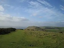 Hambury Tout seen from Bindon Hill on the eastern side of Lulworth Cove | |
| Highest point | |
| Elevation | 134 m (440 ft)[1] |
| Geography | |
| Location | Dorset, England |
| Parent range | Purbeck Hills |
| OS grid | SY815802 |
| Topo map | OS Landranger 194 |
Hambury Tout is a large chalk hill by the coast near Lulworth, Dorset, England.[2] It overlooks Lulworth Cove to the west. Hambury Tout is the site of an ancient burial mound.[3]
References
- ↑ Ordnance Survey Landranger 1:50,000 map series, No. 194.
- ↑ "Lulworth Cove - Discussion and Encyclopedia Article. Who is Lulworth Cove? What is Lulworth Cove? Where is Lulworth Cove? Definition of Lulworth Cove. Meaning of Lulworth Cove". Archived from the original on 27 July 2011. Retrieved 5 March 2010.
- ↑ Access Languages
50°37′19″N 2°15′42″W / 50.6220°N 2.2617°W
This article is issued from Wikipedia. The text is licensed under Creative Commons - Attribution - Sharealike. Additional terms may apply for the media files.