Hall, Montana | |
|---|---|
 Hall  Hall | |
| Coordinates: 46°35′12″N 113°11′49″W / 46.58667°N 113.19694°W | |
| Country | United States |
| State | Montana |
| County | Granite |
| Area | |
| • Total | 0.17 sq mi (0.43 km2) |
| • Land | 0.17 sq mi (0.43 km2) |
| • Water | 0.00 sq mi (0.00 km2) |
| Elevation | 4,206 ft (1,282 m) |
| Population (2020) | |
| • Total | 51 |
| • Density | 309.09/sq mi (119.35/km2) |
| Time zone | UTC-7 (Mountain (MST)) |
| • Summer (DST) | UTC-6 (MDT) |
| ZIP code | 59837 |
| Area code | 406 |
| GNIS feature ID | 2804295[2] |
Hall is an unincorporated community in Granite County, Montana, United States. Hall is located on Montana Highway 1, 6.2 miles (10.0 km) west-southwest of Drummond. The community has a post office with ZIP code 59837.[3][4]
Originally called Hall's Crossing, the Northern Pacific Railroad constructed a branch line across this land in 1877.[5]
Demographics
| Census | Pop. | Note | %± |
|---|---|---|---|
| 2020 | 51 | — | |
| U.S. Decennial Census[6] | |||
References
- ↑ "ArcGIS REST Services Directory". United States Census Bureau. Retrieved September 5, 2022.
- 1 2 "Hall". Geographic Names Information System. United States Geological Survey, United States Department of the Interior.
- ↑ United States Postal Service (2012). "USPS - Look Up a ZIP Code". Retrieved February 15, 2012.
- ↑ "Postmaster Finder - Post Offices by ZIP Code". United States Postal Service. Retrieved July 9, 2014.
- ↑ "Hall". Montana Place Names Companion. Montana Historical Society. Retrieved April 5, 2021.
- ↑ "Census of Population and Housing". Census.gov. Retrieved June 4, 2016.
Municipalities and communities of Granite County, Montana, United States | ||
|---|---|---|
| Towns | 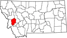 Granite County map | |
| CDPs | ||
| Unincorporated communities |
| |
| Ghost towns | ||
This article is issued from Wikipedia. The text is licensed under Creative Commons - Attribution - Sharealike. Additional terms may apply for the media files.