Hahake | |
|---|---|
District | |
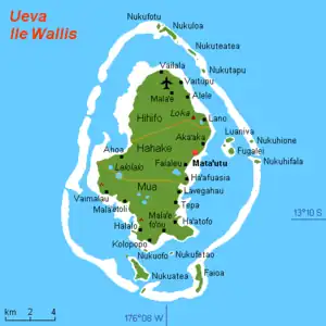 Map of Wallis Island showing the 3 districts: Hahake is located in the middle | |
| Coordinates: 13°17′S 176°11′W / 13.283°S 176.183°W | |
| Country | |
| Territory | |
| Island | Wallis |
| Chiefdom | Uvea |
| Capital | Mata Utu |
| Area | |
| • Total | 27.8 km2 (10.7 sq mi) |
| Population (2018) | |
| • Total | 3,415 |
| Time zone | UTC+12 |
| No. of municipalities | 6 |
Hakake (Uvean for "East") is one of the 5 districts of Wallis and Futuna, located in Wallis Island, in the Pacific Ocean. It is part of the Chiefdom of Uvea.
Geography
Located in the middle of the island, Hahake borders with the districts of Hihifo and Mua. Mata Utu (also spelled Mata-Utu and Matāʻutu) is the capital of the district, and of the Wallis and Futuna Territory as a whole.
The district is divided into 6 municipal villages:[1]
| Village | Population |
|---|---|
| Mata Utu | 1,029 |
| Liku | 605 |
| Falaleu | 572 |
| Aka'aka | 474 |
| Ahoa | 436 |
| Haafuasia | 299 |
See also
References
- ↑ "Population municipale des villages des îles Wallis et Futuna (recensement 2018)". INSEE. Retrieved 21 February 2020.
External links
Wikimedia Commons has media related to Hahake District.
- Map showing the location of Mata Utu
- Picture of the lagoon of Mata Utu (Archived 2009-10-31)
- Google (4 September 2013). "Hahake District" (Map). Google Maps. Google. Retrieved 4 September 2013.
Wallis and Futuna articles | |||
|---|---|---|---|
| Islands |  | ||
| Chiefdoms and districts | |||
| Geography | |||
| Politics | |||
| Economy | |||
| Culture | |||
| |||
This article is issued from Wikipedia. The text is licensed under Creative Commons - Attribution - Sharealike. Additional terms may apply for the media files.