| Gulf of Saint-Malo | |
|---|---|
 Gulf of Saint-Malo | |
| Location | English Channel |
| Coordinates | 49°02′07″N 2°07′54″W / 49.03528°N 2.13167°W |
| Type | Gulf |
| Basin countries | |
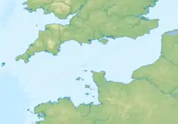
The Gulf of Saint-Malo is a part of the south-western English Channel between Brittany, Normandy, and the Channel Islands.
Formed by subsidence and flooding of a continental zone of about 8 500 km2, it extends from the Bréhat archipelago in the west to Guernsey and Alderney in the north and to the west coast of Cotentin (Normandy) in the east.
Geography
Islands
In addition to Bréhat and its archipelago, the Channel Islands Jersey and Guernsey (and the latter's dependencies Alderney and Sark), the Chausey archipelago is situated in the centre.
Towns
From west to north-east:
- Saint-Brieuc
- Dinard
- Saint-Malo
- Le Mont-Saint-Michel
- Granville
- Barneville-Carteret
- Les Pieux
- Saint-Hélier (capital of Jersey)
- Saint Peter Port (capital of Guernsey)
Rivers
Several rivers flow into the Gulf of Saint Malo: the Rance estuary is between Dinard et Saint-Malo ; the Sélune and the Sée form a common estuary in the Bay of Mont-Saint-Michel ; the Couesnon enters the sea in by Mont-Saint-Michel. The mouths of the Thar, the Sienne and the Gerfleur are on the Cotentin coast.
Environment
Notes
- 1 2 Dependency of the British Crown, not part of the United Kingdom but not a sovereign state.
References
- Archived 29 August 2016 at the Wayback Machine
49°00′N 02°30′W / 49.000°N 2.500°W