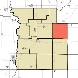
Greene Township | |
|---|---|
 Location in Parke County | |
| Coordinates: 39°49′11″N 87°04′06″W / 39.81972°N 87.06833°W | |
| Country | |
| State | |
| County | Parke |
| Government | |
| • Type | Indiana township |
| Area | |
| • Total | 35.65 sq mi (92.3 km2) |
| • Land | 35.55 sq mi (92.1 km2) |
| • Water | 0.09 sq mi (0.2 km2) 0.25% |
| Elevation | 676 ft (206 m) |
| Population (2010) | |
| • Total | 423 |
| • Density | 11.9/sq mi (4.6/km2) |
| Time zone | UTC-5 (Eastern (EST)) |
| • Summer (DST) | UTC-4 (EDT) |
| ZIP codes | 46175, 47872, 47989 |
| Area code | 765 |
| GNIS feature ID | 453350 |
Greene Township is one of thirteen townships in Parke County, Indiana, United States. As of the 2010 census, its population was 423 and it contained 191 housing units.[2]
History
The Portland Mills Bridge was listed on the National Register of Historic Places in 1978.[3]
Geography
According to the 2010 census, the township has a total area of 35.65 square miles (92.3 km2), of which 35.55 square miles (92.1 km2) (or 99.72%) is land and 0.09 square miles (0.23 km2) (or 0.25%) is water.[2]
Unincorporated towns
- Guion at 39°50′34″N 87°06′41″W / 39.842820°N 87.111400°W
- Milligan at 39°50′44″N 87°02′18″W / 39.845599°N 87.038344°W
- Parkeville at 39°49′01″N 87°05′04″W / 39.816987°N 87.084456°W
(This list is based on USGS data and may include former settlements.)
Cemeteries
The township contains these nine cemeteries: Bruin, Clodfelter, Jarvis, Lane, Mount Moriah, Philadelphia, Raccoon, Seybold and Spencer.
School districts
- North Central Parke Community School Corporation
Political districts
- State House District 44
- State Senate District 38
References
- "Greene Township, Parke County, Indiana". Geographic Names Information System. United States Geological Survey, United States Department of the Interior. Retrieved November 1, 2009.
- United States Census Bureau 2009 TIGER/Line Shapefiles
- IndianaMap
- ↑ "US Board on Geographic Names". United States Geological Survey. October 25, 2007. Retrieved May 9, 2017.
- 1 2 "Population, Housing Units, Area, and Density: 2010 - County -- County Subdivision and Place -- 2010 Census Summary File 1". United States Census. Archived from the original on February 12, 2020. Retrieved May 10, 2013.
- ↑ "National Register Information System". National Register of Historic Places. National Park Service. July 9, 2010.
External links
This article is issued from Wikipedia. The text is licensed under Creative Commons - Attribution - Sharealike. Additional terms may apply for the media files.