Grant County International Airport | |||||||||||||||||||||||||||
|---|---|---|---|---|---|---|---|---|---|---|---|---|---|---|---|---|---|---|---|---|---|---|---|---|---|---|---|
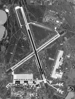
 USGS 1996 orthophoto | |||||||||||||||||||||||||||
| Summary | |||||||||||||||||||||||||||
| Airport type | Public | ||||||||||||||||||||||||||
| Owner | Port of Moses Lake | ||||||||||||||||||||||||||
| Serves | Grant County, Washington (Primarily Moses Lake) | ||||||||||||||||||||||||||
| Elevation AMSL | 1,189 ft / 362 m | ||||||||||||||||||||||||||
| Coordinates | 47°12′31″N 119°19′09″W / 47.20861°N 119.31917°W | ||||||||||||||||||||||||||
| Website | PortOfMosesLake.com | ||||||||||||||||||||||||||
| Map | |||||||||||||||||||||||||||
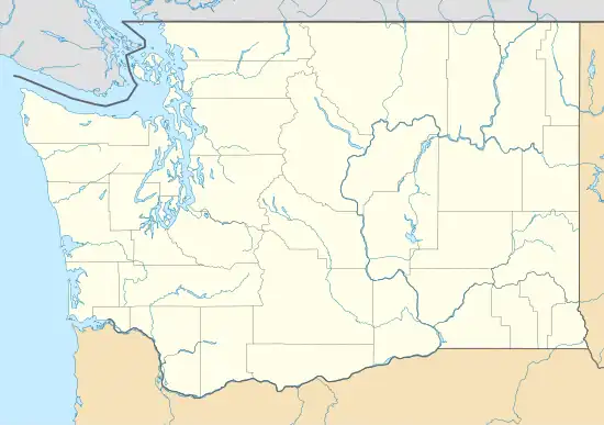
 MWH Location of airport in Washington  MWH MWH (the United States) | |||||||||||||||||||||||||||
| Runways | |||||||||||||||||||||||||||
| |||||||||||||||||||||||||||
| Statistics (2018) | |||||||||||||||||||||||||||
| |||||||||||||||||||||||||||
Grant County International Airport (IATA: MWH, ICAO: KMWH, FAA LID: MWH) is a public use airport in the northwest United States, located six miles (10 km) northwest of the central business district of Moses Lake in Grant County, Washington. Formerly a military facility, the airport is owned by the Port of Moses Lake,[1] and its 13,500-foot (4,110 m) runway is the 17th longest in the U.S.
According to Federal Aviation Administration records, the airport had 1,369 passenger boardings (enplanements) in calendar year 2008,[2] 2,920 enplanements in 2009, and 1,442 in 2010.[3] It is included in the National Plan of Integrated Airport Systems for 2011–2015, which categorized it as a general aviation airport.[4]
History
Opened as a training airfield during World War II, the facility was operated by the U.S. Air Force as Larson Air Force Base until 1966.[5][6]
On 24 June 1969, Japan Airlines Flight 90, a Convair 880, crashed on take-off from runway 32R at Grant County International Airport. The power was reduced on the number four engine during take-off, however, the aircraft continued to yaw to the right until the number four engine struck and slid off the runway. It burst into flames, killing three of the five crew members on board. The probable cause was a "delayed corrective action during a simulated critical-engine-out takeoff maneuver resulting in an excessive sideslip from which full recovery could not be effected."
In September 2019, Boeing stored 100 of its undelivered 737 MAX airplanes at the Moses Lake airport while it awaited clearance from the FAA and other aviation regulators to return the jet to commercial service.
Passenger air service to and from Moses Lake ended on 8 June 2010.[7]
Overview
With 4,650 acres (7.3 sq mi; 18.8 km2) and a 13,500-foot (4,110 m) main runway, it is one of the largest airports in the United States. Moses Lake is famous for good flying weather, as it is located on the east side of the Cascade Range, in the semi-arid desert of central Washington.
Grant County International Airport was an alternate landing site for the NASA Space Shuttle.[8]
Scheduled passenger flights on Big Sky Airlines to Boise and Portland were discontinued on September 1, 2006. The service was subsidized by the Essential Air Service program. United Express, operated by SkyWest Airlines offered nonstop flights to Seattle from June 2009 until June 2010. The airport currently has no commercial passenger air service.
The airport was used for heavy jet training by Japan Airlines (JAL) for over forty years, until the closing of their training offices in March 2009.[9][10][11][12][13][14][15] The airport also had been used for flight testing of the Mitsubishi SpaceJet.[16]
In November 1974, the airport hosted a new Supersonic Transport (SST) Concorde for a month during FAA certification testing.[17][18][19]
It is also utilized by the U.S. Air Force and Boeing as a testing facility. Most of the traffic at the airport is general and military aviation.
In 2011, the 92nd Air Refueling Wing at Fairchild AFB in Spokane temporarily moved its KC-135 R/T fleet and operations to Moses Lake while Fairchild's runway underwent reconstruction and other infrastructure improvements, to include an upgrade to the base's aviation fuel distribution system.[20][21]
The main campus for Big Bend Community College is also located on the grounds of the airport.
After the grounding of all Boeing 737 MAXs from March 2019, approximately 50 of the grounded airplanes were parked at the airport. This was originally seen as an economic opportunity for the airport,[22] but later caused concern as the number of planes stored kept increasing, to approximately 130 by October 2019.[23]
Facilities and aircraft

Grant Co. International Airport covers an area of 4,650 acres (1,880 ha) at an elevation of 1,189 feet (362 m) above sea level. It has five runways:[1]
- Runway 14L/32R is 13,503 by 200 feet (4,116 by 61 m), with an asphalt/concrete surface
- Runway 4/22 is 10,000 by 100 feet (3,048 by 30 m), with an asphalt/concrete surface
- Runway 9/27 is 3,500 by 90 feet (1,067 by 27 m), with a concrete surface
- Runway 18/36 is 3,327 by 75 feet (1,014 by 23 m), with an asphalt surface
- Runway 14R/32L is 2,936 by 75 feet (895 by 23 m), with a concrete surface
For the 12-month period ending December 31, 2018, the airport had 77,335 aircraft operations, an average of 212 per day: 61% general aviation, 15% military, 10% air carrier and 14% air taxi. At that time there were 49 fixed-wing aircraft and 2 gliders based at this airport: 84% single-engine, 12% multi-engine, and 4% glider.[1]
Cargo carriers
| Airlines | Destinations |
|---|---|
| Ameriflight | Burlington/Mount Vernon, Seattle–Boeing |
| FedEx Feeder | Spokane |
See also
References
- 1 2 3 4 FAA Airport Form 5010 for MWH PDF. Federal Aviation Administration. Effective April 5, 2012.
- ↑ "Enplanements for CY 2008" (PDF, 1.0 MB). faa.gov. Federal Aviation Administration. December 18, 2009.
- ↑ "Enplanements for CY 2010" (PDF, 189 KB). faa.gov. Federal Aviation Administration. October 4, 2011.
- ↑ "2011–2015 NPIAS Report, Appendix A" (PDF). faa.gov. Federal Aviation Administration. October 4, 2010. Archived from the original (PDF, 2.03 MB) on October 27, 2012.
- ↑ "Grant County airport". Spokesman-Review. (Spokane, Washington). (photo). September 16, 1966. p. 6.
- ↑ "Larson AFB".
- ↑ "I Fly Moses Lake". Archived from the original on July 26, 2010. Retrieved July 21, 2010.
- ↑ John Pike. "SPACE SHUTTLE EMERGENCY LANDING SITES".
- ↑ "Japan Airlines: fuel too pricey for Moses Lake". KOMO TV (Associated Press). November 20, 2008. Archived from the original on August 4, 2008. Retrieved October 22, 2009.
- ↑ "Japan Air Lines welcomed". Spokane Daily Chronicle. November 22, 1968. p. 5.
- ↑ Geranios, Nicholas K. (December 26, 1988). "Baseless existence". Spokane Chronicle. (Washington). Associated Press. p. A3.
- ↑ Lynch, Lynne (November 10, 2008). "JAL marks 40th anniversary". Columbia Basin Herald. Retrieved June 21, 2013.
- ↑ Crowell, Todd (February 4, 1980). "An honorable match". Spokesman-Review. (Spokane, Washington). p. 9.
- ↑ "Japan Air Lines trains 747 pilots at U.S. facility". Pittsburgh Press. UPI. August 10, 1982. p. C-10.
- ↑ Hansen, Dan (November 23, 2008). "JAL ends Moses Lake stay". Seattle Times. (Spokesman-Review). Archived from the original on June 24, 2013. Retrieved June 21, 2013.
- ↑ "Report: Mitsubishi to close Washington operations, halt SpaceJet flight tests". May 23, 2020.
- ↑ "Concorde will undergo testing in Washington". Bend Bulletin. (Oregon). Associated Press. September 25, 1974. p. 15.
- ↑ "Supersonic jet dazzles Inland Empire". Spokane Daily Chronicle. (Washington). (photo). November 8, 1974. p. 3.
- ↑ Cowles, Cheney (November 8, 1974). "SST streaks in for basin tests". Spokane Daily Chronicle. (Washington). p. 6.
- ↑ Wasson, David (January 20, 2011). "Work relocates Fairchild tankers". Spokesman-Review. (Spokane, Washington). Retrieved June 21, 2013.
- ↑ King, Scott (January 24, 2011). "Fairchild relocates KC-135 flying OPS". United States Air Force. 92nd Air Refueling Wing Public Affairs. Archived from the original on April 17, 2012. Retrieved June 21, 2013.
- ↑ "Boeing 737s grounding could mean positives for Moses Lake". August 23, 2019.
- ↑ "As 737s increase at Moses Lake airport, concern about storage grows". October 15, 2019.
Other sources
- Essential Air Service documents (Docket OST-1998-3344) from the U.S. Department of Transportation:
- Order 2001-6-22 (June 28, 2001): selecting Big Sky Airlines, to provide essential air service at Ephrata/Moses Lake, Washington, for a two-year period at an annual subsidy of $479,702.
- Order 2004-12-18 (December 30, 2004): selecting Big Sky Transportation Company, Inc., to continue providing essential air service (EAS) at Ephrata/Moses Lake, Washington, for a new two-year period. This order establishes a subsidy of $1,698,922 per year for service consisting of twelve nonstop round trips to Portland and six nonstop round trip to Boise each week.
- Order 2006-6-8 (June 12, 2006): directing interested persons to show cause why the department should not terminate the subsidy eligibility of Ephrata/Moses Lake, Washington, under the essential air service (EAS) program and allow Big Sky Transportation Company, Inc., d/b/a Big Sky Airlines (Big Sky) to suspend service there as of August 1, 2006.
- Order 2006-8-16 (August 22, 2006): terminating the subsidy eligibility of Ephrata/Moses Lake, Washington, under the essential air service (EAS) program and allowing Big Sky Transportation Company, Inc., d.b.a. Big Sky Airlines to suspend service, if it chooses.
External links
- Grant County International Airport at Port of Moses Lake website
- Grant County International Airport at WSDOT Aviation
- Aerial image as of July 1996 from USGS The National Map
- FAA Airport Diagram (PDF), effective December 28, 2023
- FAA Terminal Procedures for MWH, effective December 28, 2023
- Resources for this airport:
- AirNav airport information for KMWH
- ASN accident history for MWH
- FlightAware airport information and live flight tracker
- NOAA/NWS weather observations: current, past three days
- SkyVector aeronautical chart for KMWH
- FAA current MWH delay information
- Larson Air Force Base – Grant County International Airport at HistoryLink