Goode Township | |
|---|---|
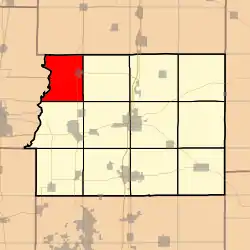 Location in Franklin County | |
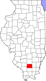 Franklin County's location in Illinois | |
| Coordinates: 38°04′50″N 89°05′05″W / 38.08056°N 89.08472°W | |
| Country | United States |
| State | Illinois |
| County | Franklin |
| Established | November 4, 1884 |
| Area | |
| • Total | 28.22 sq mi (73.1 km2) |
| • Land | 27.93 sq mi (72.3 km2) |
| • Water | 0.29 sq mi (0.8 km2) 1.03% |
| Elevation | 433 ft (132 m) |
| Population (2010) | |
| • Estimate (2016)[1] | 2,653 |
| • Density | 97.2/sq mi (37.5/km2) |
| Time zone | UTC-6 (CST) |
| • Summer (DST) | UTC-5 (CDT) |
| ZIP codes | 62865, 62883, 62884 |
| FIPS code | 17-055-30406 |
Goode Township is one of twelve townships in Franklin County, Illinois, USA. As of the 2010 census, its population was 2,715 and it contained 1,268 housing units.[2]
Geography
According to the 2010 census, the township has a total area of 28.22 square miles (73.1 km2), of which 27.93 square miles (72.3 km2) (or 98.97%) is land and 0.29 square miles (0.75 km2) (or 1.03%) is water.[2]
Cities, towns, villages
- Sesser (vast majority)
Unincorporated towns
- Meyer
(This list is based on USGS data and may include former settlements.)
Cemeteries
The township contains these four cemeteries: Bear Point, Maple Hill, Mitchell and Youngblood.
Major highways
Demographics
| Census | Pop. | Note | %± |
|---|---|---|---|
| 2016 (est.) | 2,653 | [1] | |
| U.S. Decennial Census[3] | |||
School districts
- Sesser-Valier Community Unit School District 196
Political districts
- Illinois' 12th congressional district
- State House District 117
- State Senate District 59
References
- "Goode Township, Franklin County, Illinois". Geographic Names Information System. United States Geological Survey, United States Department of the Interior. Retrieved January 16, 2010.
- United States Census Bureau 2007 TIGER/Line Shapefiles
- United States National Atlas
- 1 2 "Population and Housing Unit Estimates". Retrieved June 9, 2017.
- 1 2 "Population, Housing Units, Area, and Density: 2010 - County -- County Subdivision and Place -- 2010 Census Summary File 1". United States Census. Archived from the original on February 12, 2020. Retrieved May 28, 2013.
- ↑ "Census of Population and Housing". Census.gov. Retrieved June 4, 2016.
External links
Places adjacent to Goode Township, Franklin County, Illinois | |
|---|---|
Municipalities and communities of Franklin County, Illinois, United States | ||
|---|---|---|
| Cities | Map of Illinois highlighting Franklin County | |
| Villages | ||
| Townships | ||
| CDP | ||
| Other unincorporated communities | ||
| Footnotes | ‡This populated place also has portions in an adjacent county or counties | |
This article is issued from Wikipedia. The text is licensed under Creative Commons - Attribution - Sharealike. Additional terms may apply for the media files.