| The Glamis Manse Stone | |
|---|---|
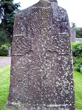
 The front of the Glamis Manse Stone with its intricately carved cross. | |
| Material | Old Red Sandstone |
| Height | 2.76 metres (9 ft 1 in) |
| Symbols |
|
| Created | Ninth Century CE |
| Discovered | 1811 |
| Place | Glamis, Angus, Scotland |
| Classification | Type II cross slab |
| Culture | Picto-Scottish |
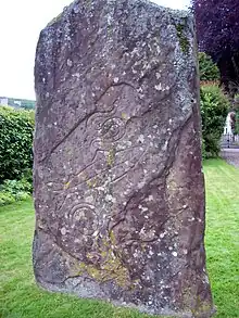
The Glamis Manse Stone, also known as Glamis 2, is a Class II Pictish stone at the village of Glamis, Angus, Scotland. Dating from the 9th century, it is located outside the Manse, close to the parish church.[1] It is inscribed on one side with a Celtic cross and on the other with a variety of Pictish symbols. It is a scheduled monument.[2]
Location
The cross slab is situated at the northeast edge of Glamis village in the grounds of the Manse, close to St Fergus church (grid reference NO38584686).[3]
Description
The stone is a cross-slab 2.76 metres (9 ft 1 in) high, 1.5 metres (4 ft 11 in) wide and 24 centimetres (9.4 in) thick.[4] The slab is pedimented and carved on the cross face in relief, and the rear face bears incised symbols. It falls into John Romilly Allen and Joseph Anderson's classification system as a class II stone.[5][6]
The cross face bears a Celtic cross carved in relief with ogee armpits. It has an incised ring and the shaft and roundel are decorated with knotwork interlace designs, with the arms and portion above the roundel holding zoomorphic interlaces. The cross is surrounded by incised symbols and figural representations. In the lower left-hand quadrant is depiction of two bearded, long-haired men apparently fighting with axes. Above them is what appears to be a cauldron with human legs dangling out of it. The lower right-hand quadrant holds what appears to be either a deer or a hound's head, similar to symbols found on the Monifieth 2 stone, above a triple disc symbol. The top right quadrant holds a centaur holding a pair of axes. The top left quadrant holds what has been interpreted as a lion.[4]
The rear of the slab holds three incised symbols: a serpent above a fish, with a mirror at the bottom.
Historian Lloyd Laing has noted some peculiarities of the layout of the cross face. Firstly, the arms are not perfectly perpendicular to the shaft, being rotated slightly (2.5° anticlockwise). Secondly, the axis of the interlace of the cross roundel is skewed from the axis of the shaft by some 13°.[4]
Relationship with other stones

The Glamis manse stone belongs to the Aberlemno School of Pictish sculpture as extended by Laing from Ross Trench Jellicoe's original proposed list. In addition to the Glamis manse stone, stones in the Aberlemno School include Aberlemno 2 (the Kirkyard Stone), Aberlemno 3, Menmuir 1, Kirriemuir 1, Monifieth 2, Eassie, Rossie Priory, and Glamis 1 (Hunter's Hill).[4][7]
See also
- Hunter's Hill Stone (Glamis 1)
Notes
- ↑ Ritchie 1997, p.30.
- ↑ Historic Environment Scotland. "Glamis 2, cross slab 15m S of 10 Kirkwynd (SM152)". Retrieved 26 February 2019.
- ↑ "Site details for Glamis 2 stone", Royal Commission on the Ancient and Historical Monuments of Scotland, Canmore Database, retrieved 2 December 2010
- 1 2 3 4 Laing, Lloyd (2001), "The date and context of the Glamis, Angus, carved Pictish stones" (PDF), Proceedings of the Society of Antiquaries of Scotland, 131: 223–239, archived from the original (PDF) on 18 December 2010, retrieved 29 November 2010
- ↑ Allen, J. Romilly; Anderson, J. (1903), Early Christian Monuments of Scotland, vol. 1, Balgavies, Angus: Pinkfoot Press (1993 facsimile), pp. 221–223
- ↑ Allen, J. Romilly (1890), "Preliminary list of sculptured stones older than A.D. 1100, with symbols and Celtic ornament, in Scotland" (PDF), Proceedings of the Society of Antiquaries of Scotland, 24: 510–525, retrieved 29 November 2010
- ↑ Trench-Jellicoe, Ross (1999), "A missing figure on slab fragment no 2 from Monifieth, Angus, the a'Chill Cross, Canna, and some implications of the development of a variant form of the Virgin's hairsyle and dress in early medieval Scotland" (PDF), Proceedings of the Society of Antiquaries of Scotland, 129: 597–647, archived from the original (PDF) on 25 August 2009, retrieved 29 November 2010
References
- Ritchie, Anna (1997). Meigle Museum Pictish Carved Stones: The Official Souvenir Guide. Historic Scotland. ISBN 1-900168-27-8. OCLC 51913539.