Gerstungen | |
|---|---|
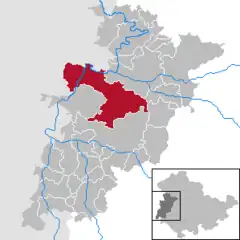
Location of Gerstungen within Wartburgkreis district  | |
 Gerstungen  Gerstungen | |
| Coordinates: 50°57′45″N 10°3′35″E / 50.96250°N 10.05972°E | |
| Country | Germany |
| State | Thuringia |
| District | Wartburgkreis |
| Government | |
| • Mayor (2022–28) | Tim Rommert[1] |
| Area | |
| • Total | 149.98 km2 (57.91 sq mi) |
| Elevation | 205 m (673 ft) |
| Population (2022-12-31)[2] | |
| • Total | 9,011 |
| • Density | 60/km2 (160/sq mi) |
| Time zone | UTC+01:00 (CET) |
| • Summer (DST) | UTC+02:00 (CEST) |
| Postal codes | 99834 |
| Dialling codes | 036922 |
| Vehicle registration | WAK |
| Website | www.gerstungen.de |
Gerstungen is a municipality in the Wartburgkreis district of Thuringia, Germany. It is 42 kilometers southwest of the geographic center of Germany, located in Niederdorla. In July 2018 the former municipalities of Marksuhl and Wolfsburg-Unkeroda were merged into Gerstungen.
History

Between 1945 and 1990, Gerstungen station served as East German inner German border crossing on the Thuringian Railway. The crossing was open for trains travelling between the Soviet Zone of occupation in Germany (till 1949, thereafter the East German Democratic Republic, or West Berlin and the American zone of occupation (till 1949) and thereafter the West German Federal Republic of Germany. The traffic was subject to the Interzonal traffic regulations, that between West Germany and West Berlin followed the special regulations of the Transit Agreement (1972).

References
- ↑ Gewählte Bürgermeister - aktuelle Landesübersicht, Freistaat Thüringen, accessed 10 November 2022.
- ↑ "Bevölkerung der Gemeinden, erfüllenden Gemeinden und Verwaltungsgemeinschaften in Thüringen Gebietsstand: 31.12.2022" (in German). Thüringer Landesamt für Statistik. June 2023.
