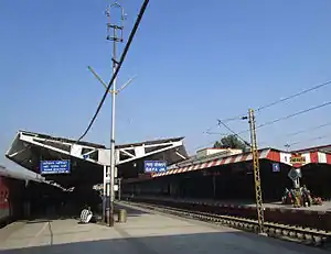
Gaya Junction | |
|---|---|
 Gaya railway junction platform no. 2&3 | |
| General information | |
| Location | Gaya, Gaya district, Bihar India |
| Coordinates | 24°48′12″N 84°59′58″E / 24.80333°N 84.99944°E |
| Elevation | 117 metres (384 ft) |
| Owned by | Indian Railways |
| Operated by | East Central Railway zone |
| Line(s) | Grand Chord Howrah–Gaya–Delhi line Howrah–Prayagraj–Mumbai line Asansol–Gaya section Gaya–Pandit Deen Dayal Upadhyaya Junction section Patna–Gaya line Gaya–Kiul line |
| Platforms | 9 |
| Tracks | 14 |
| Construction | |
| Parking | Available |
| Other information | |
| Status | Functional |
| Station code | GAYA |
| Zone(s) | East Central Railway zone |
| Division(s) | Pandit Deen Dayal Upadhyaya |
| History | |
| Opened | 1879 |
| Electrified | Yes |
| Previous names | East Indian Railway Company Eastern Railway zone |
| Location | |
 Gaya Junction Location in Bihar | |
| Interactive map | |
Gaya Junction railway station is a junction station serving the city of Gaya, the headquarters of Gaya district and Magadh Division in the Indian state of Bihar. Gaya is in the Pandit Deen Dayal Upadhyaya railway division of the East Central Railway zone. Grand Chord rail-line that connects Howrah and New Delhi passes through Gaya. It lies between Pandit Deen Dayal Upadhyaya Junction on the Delhi side and Dhanbad Junction on the Howrah side. It is located at 24°48′13″N 84°59′57″E / 24.80361°N 84.99917°E.[1] It has an elevation of 117 metres (384 ft). Gaya is connected with most of the states through rail network. Very few trains do-not stop here- sealdah duranto, bhubaneswar duranto, jharkhand sampark kranti and Odisha sampark kranti. There are also two other broad-gauge train lines from Gaya, one to Patna and the other to Kiul Junction. The city has two major railway stations: Gaya Junction & Manpur Junction. Gaya is well connected with Patna, Jehanabad, Biharsharif, Rajgir, Islampur, Nawada, Dehri on sone through daily passenger and express train services.
History
Several years before the Grand Chord was built, a connection from the Howrah–Delhi main line to Gaya was developed in 1900 and the South Bihar Railway Company (operated by EIR) had laid a line from Lakhisarai to Gaya in 1879.[2] The Grand Chord was opened on 6 December 1906.[3]
- New developments
In February 2012, the Indian Railways had planned to set up a Railway Station Development Corporation (RSDC) that will work on improving the major railway stations including Gaya Junction by building and developing Restaurants, shopping areas and food plaza for commercial business and improving passenger amenities.[4]
Facilities
There are 9 platforms in the Gaya Junction which are from platform 1 to 7 and 1A & 1B. There are 1 Pilgrim Platform also, where the pilgrim train stop. The platforms are interconnected with foot overbridges (FOB). It has three foot overbridge, the station houses all the major facilities like waiting rooms, computerized reservation facility, food plaza, dormitory, retiring rooms, cafeteria, bookshop, etc.[5] Existing facilities are being revamped for developing it as model station.
Trains
Gaya Junction's location on the Delhi–Kolkata Grand chord route, makes it served by numerous express and superfast trains from all over the country. Gaya Junction is the second most important railway station in Bihar after Patna and second largest in terms of platforms after Patna Jn. It is a junction and is connected to all the major cities such as New Delhi, Kolkata, Mumbai and Chennai through important broad-gauge routes (direct trains). Now it is also directly connected to Guwahati (N-E India). There is a direct train
- Mahabodhi Express from New Delhi to Gaya daily.
- Gaya–Anand Vihar Garib Rath Express has been added from Gaya to Anand Vihar Terminal (Delhi),which runs weekly.
- Ekatmata Express from Lucknow.
- Howrah–Gaya Express from Howrah Railway Station.
There are direct trains from Gaya to important stations in India like Delhi, Kolkata, Dhanbad, Chennai, Kamakhya–Guwahati, Ranchi, Patna ,Parasnath(Shikharji), Bokaro, Varanasi, Lucknow, Kota, Kanpur, Allahabad, Agra, Bareilly, Mathura, Jabalpur, Bhopal, Indore, Nagpur, Mumbai, Pune, Puri, Ahmedabad, Jodhpur, Amritsar, Dehradun, Kalka, Jammu, Gwalior, Dehradun, Ranchi, Jamshedpur (Tatanagar), Bhuvaneshwar, etc. Several electrified local passenger trains also run from Gaya to neighbouring destinations at regular intervals.[6][7] Gaya Patna daily bond passenger train also plays a very essential role in the development of Bihar. The train starts from Gaya Junction to Patna Junction via Bela, Chakand, Jehanabad, Makhdoompur.
References
- ↑ "Gaya Junction". Wikimapia. Retrieved 1 December 2011.
- ↑ Saxena, R.P. "Indian Railway History timeline". Archived from the original on 29 February 2012. Retrieved 20 November 2011.
- ↑ "As the traffic continued to grow even beyond the capacity of the". Symphony of Progress – The Saga of Eastern Railway. Retrieved 20 November 2011.
- ↑ Verma, Kumod (11 February 2012). "Railways to set up body to develop stations". The Times of India. Archived from the original on 9 December 2012. Retrieved 27 April 2012.
- ↑ "Alphabetically List of Locations (Irrespective Of States) Where Computerized Reservation Facilities Are Available". Indian Railways. Archived from the original on 3 July 2013. Retrieved 18 April 2012.
- ↑ "Trains at Gaya". India Rail Info. Retrieved 1 April 2012.
- ↑ "Gaya Junction Railway Station Details". indiantrains.org. Archived from the original on 8 April 2014. Retrieved 1 April 2012.