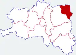
Foping County
佛坪县 | |
|---|---|
 Location in Hanzhong | |
.png.webp) Hanzhong in Shaanxi | |
| Country | People's Republic of China |
| Province | Shaanxi |
| Prefecture-level city | Hanzhong |
| Area | |
| • Total | 1,279 km2 (494 sq mi) |
| Population (2018) | |
| • Total | 32,584[1] |
| Time zone | UTC+8 (China standard time) |
| Postal code | 723400 |
| Licence plates | 陕F |
| Website | www |
Foping (Chinese: 佛坪; pinyin: Fópíng) is a county under the administration and in the northeast corner of Hanzhong City, in the south of Shaanxi province, China.
The county was first established in 1824.[2]
It has been called the 'home of dogwood', having over 100,000 Mu (ca. 162 sq km.) of dogwood forests.[3] The Qinling panda was first discovered in Foping.[4][5]
Administrative divisions
As 2019, Foping County is divided to 1 subdistrict and 6 towns.[6]
- Subdistricts
- Yuanjiazhuang Subdistrict (袁家庄街道)
- Towns
- Chenjiaba (陈家坝镇)
- Daheba (大河坝镇)
- Xichahe (西岔河镇)
- Yueba (岳坝镇)
- Changjiaoba (长角坝镇)
- Shidunhe (石墩河镇)
Climate
| Climate data for Foping (2001–2020 normals, extremes 1981–2010) | |||||||||||||
|---|---|---|---|---|---|---|---|---|---|---|---|---|---|
| Month | Jan | Feb | Mar | Apr | May | Jun | Jul | Aug | Sep | Oct | Nov | Dec | Year |
| Record high °C (°F) | 17.7 (63.9) |
22.7 (72.9) |
30.2 (86.4) |
31.5 (88.7) |
34.9 (94.8) |
37.0 (98.6) |
38.7 (101.7) |
37.2 (99.0) |
36.8 (98.2) |
28.3 (82.9) |
24.6 (76.3) |
19.0 (66.2) |
38.7 (101.7) |
| Mean daily maximum °C (°F) | 7.7 (45.9) |
10.2 (50.4) |
16.1 (61.0) |
21.7 (71.1) |
24.5 (76.1) |
28.0 (82.4) |
29.7 (85.5) |
29.0 (84.2) |
23.4 (74.1) |
18.7 (65.7) |
13.6 (56.5) |
8.7 (47.7) |
19.3 (66.7) |
| Daily mean °C (°F) | 1.8 (35.2) |
4.3 (39.7) |
9.3 (48.7) |
14.2 (57.6) |
17.6 (63.7) |
21.4 (70.5) |
23.6 (74.5) |
22.9 (73.2) |
18.3 (64.9) |
13.2 (55.8) |
7.8 (46.0) |
2.9 (37.2) |
13.1 (55.6) |
| Mean daily minimum °C (°F) | −2.2 (28.0) |
0.4 (32.7) |
4.5 (40.1) |
8.9 (48.0) |
12.7 (54.9) |
16.6 (61.9) |
19.5 (67.1) |
19.1 (66.4) |
15.1 (59.2) |
10.0 (50.0) |
4.1 (39.4) |
−0.9 (30.4) |
9.0 (48.2) |
| Record low °C (°F) | −9.7 (14.5) |
−7.9 (17.8) |
−6.8 (19.8) |
−2.9 (26.8) |
3.3 (37.9) |
8.3 (46.9) |
11.2 (52.2) |
10.4 (50.7) |
6.1 (43.0) |
−5.5 (22.1) |
−8.0 (17.6) |
−14.4 (6.1) |
−14.4 (6.1) |
| Average precipitation mm (inches) | 3.7 (0.15) |
12.8 (0.50) |
23.9 (0.94) |
57.4 (2.26) |
95.8 (3.77) |
114.6 (4.51) |
198.9 (7.83) |
178.5 (7.03) |
156.3 (6.15) |
74.3 (2.93) |
29.0 (1.14) |
5.0 (0.20) |
950.2 (37.41) |
| Average precipitation days (≥ 0.1 mm) | 4.1 | 6.4 | 8.8 | 10.2 | 12.9 | 12.2 | 15.7 | 14.3 | 14.1 | 13.5 | 8.0 | 4.0 | 124.2 |
| Average snowy days | 5.2 | 3.9 | 1.1 | 0.2 | 0 | 0 | 0 | 0 | 0 | 0 | 1.1 | 2.6 | 14.1 |
| Average relative humidity (%) | 64 | 66 | 63 | 66 | 73 | 76 | 80 | 81 | 84 | 83 | 77 | 66 | 73 |
| Mean monthly sunshine hours | 100.2 | 90.3 | 131.2 | 155.0 | 152.6 | 154.5 | 164.2 | 161.9 | 101.2 | 99.0 | 94.6 | 97.7 | 1,502.4 |
| Percent possible sunshine | 32 | 29 | 35 | 40 | 35 | 36 | 38 | 40 | 28 | 28 | 31 | 32 | 34 |
| Source: China Meteorological Administration[7][8] | |||||||||||||
References
- ↑ "China Population www.ceicdata.com". ceicdata. Retrieved 4 January 2021.
- ↑ "历史沿革 - 历史沿革 - 佛坪县人民政府". www.foping.gov.cn. Retrieved 14 January 2023.
- ↑ ""中国山茱萸之乡"佛坪县10万多亩山茱萸成熟,进入采摘季_陕西省人民政府". www.shaanxi.gov.cn. Retrieved 14 January 2023.
- ↑ 陕西省志 (in Chinese). 1990.
- ↑ 闫云霞 (1 December 2015). 在水一方 (in Chinese). Beijing Book Co. Inc. ISBN 978-7-227-06258-5.
- ↑ "统计用区划代码 www.stats.gov.cn" (in Chinese). XZQH. Retrieved 2 January 2021.
- ↑ 中国气象数据网 – WeatherBk Data (in Simplified Chinese). China Meteorological Administration. Retrieved 26 August 2023.
- ↑ 中国气象数据网 (in Simplified Chinese). China Meteorological Administration. Retrieved 26 August 2023.
33°34′N 107°59′E / 33.567°N 107.983°E
This article is issued from Wikipedia. The text is licensed under Creative Commons - Attribution - Sharealike. Additional terms may apply for the media files.