 | ||||
|---|---|---|---|---|
| Europese weg E31 | ||||
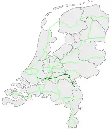 European routes in the Netherlands with E 31 in dark green | ||||
| Route information | ||||
| Maintained by Rijkswaterstaat[1] | ||||
| Major junctions | ||||
| West end | ||||
| East end | ||||
| Location | ||||
| Country | Kingdom of the Netherlands | |||
| Constituent country | Netherlands | |||
| Provinces | South Holland, Gelderland, North Brabant, Limburg | |||
| Highway system | ||||
| ||||
European route E 31 (E 31) is a north–south European route, running from Ridderkerk in the Netherlands to Hockenheim in Germany.
The highway is maintained by Rijkswaterstaat.[1]
Route description
History
Exit list
| Province | Municipality | km[2] | mi | Exit | Name | Destinations | Notes | |
|---|---|---|---|---|---|---|---|---|
| South Holland | Ridderkerk | 70.0 | 43.5 | — | Ridderkerk Interchange | West end of A15 overlap | ||
| Hendrik-Ido-Ambacht | 71.5 | 44.4 | 21 | Hendrik-Ido-Ambacht | ||||
| 75.4 | 46.9 | 22 | Alblasserdam | |||||
| Papendrecht | 77.9 | 48.4 | 23 | Papendrecht | ||||
| Sliedrecht | 80.3 | 49.9 | 24 | Sliedrecht-West | Parallelweg / Ouverture | |||
| 84.6 | 52.6 | 25 | Sliedrecht-Oost | Rivierdijk / Peulenlaan / Buitendams | ||||
| Hardinxveld-Giessendam | 87.6 | 54.4 | 26 | Hardinxveld-Giessendam | Nieuweweg | |||
| Gorinchem | 94.7 | 58.8 | 27 | Gorinchem | ||||
| 94.4 | 58.7 | — | Gorinchem Interchange | |||||
| Giessenlanden | 99.5 | 61.8 | 28 | Arkel | Spijksesteeg | |||
| Gelderland | Lingewaal | 105.3 | 65.4 | 29 | Leerdam | |||
| Geldermalsen | 114.3 | 71.0 | — | Deil Interchange | ||||
| 118.7 | 73.8 | 30a | Meteren | Eastbound exit and entrance only | ||||
| 121.1 | 75.2 | 30 | Geldermalsen | |||||
| Tiel | 123.8 | 76.9 | 31 | Wadenoijen | Lingedijk | |||
| 126.9 | 78.9 | 32 | Tiel-West | |||||
| 130.4 | 81.0 | 33 | Tiel | |||||
| Neder-Betuwe | 134.3 | 83.5 | 34 | Echteld | ||||
| 141.0 | 87.6 | 35 | Ochten | |||||
| 145.5 | 90.4 | 36 | Dodewaard | Dodewaardsestraat | ||||
| Overbetuwe | 151.5 | 94.1 | 37 | Andelst | ||||
| 154.7– 154.9 | 96.1– 96.3 | — | Valburg Interchange | East end of A15 overlap; north end of A50 overlap | ||||
| Beuningen | 148.0– 114.5 | 92.0– 71.1 | — | Ewijk Interchange | South end of A50 overlap; north end of A73 overlap | |||
| 112.4 | 69.8 | 1 | Beuningen | |||||
| Nijmegen | 109.9 | 68.3 | — | Neerbosch Interchange | Neerboscheweg | |||
| 102.5 | 63.7 | 1a | Wijchen | |||||
| 99.5 | 61.8 | 2 | Nijmegen-Dukenburg | |||||
| Heumen | 95.0 | 59.0 | 3 | Malden | ||||
| North Brabant | Cuijk | 90.4 | 56.2 | 4 | Cuijk | |||
| 85.3 | 53.0 | 5 | Haps | |||||
| Boxmeer | 81.8– 1.6 | 50.8– 0.99 | — | Rijkevoort Interchange | South end of A73 overlap; west end of A77 overlap | |||
| 4.4 | 2.7 | 1 | Boxmeer | |||||
| Limburg (Netherlands) | Gennep | 7.6 | 4.7 | 2 | Gennep | |||
| 11.1 | 6.9 | — | — | Continuation into Germany; east end of A77 overlap | ||||
1.000 mi = 1.609 km; 1.000 km = 0.621 mi
| ||||||||
See also
References
- 1 2 "Wegbeheerders". Rijkswaterstaat. Retrieved 23 January 2017.
- ↑ "Stichting Incident Management Nederland". Retrieved 18 January 2017.
External links
 Media related to European route E31 in the Netherlands at Wikimedia Commons
This article is issued from Wikipedia. The text is licensed under Creative Commons - Attribution - Sharealike. Additional terms may apply for the media files.