| Etmilyn Western Australia | |||||||||||||||
|---|---|---|---|---|---|---|---|---|---|---|---|---|---|---|---|
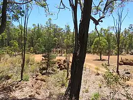
 Plavins Pit, a 1960s Bauxite mining site in the locality | |||||||||||||||
| Coordinates | 32°46′S 116°08′E / 32.77°S 116.14°E | ||||||||||||||
| Population | 0 (SAL 2016)[1][2] | ||||||||||||||
| Postcode(s) | 6213 | ||||||||||||||
| Area | 35.5 km2 (13.7 sq mi) | ||||||||||||||
| Location | |||||||||||||||
| LGA(s) | Shire of Murray | ||||||||||||||
| State electorate(s) | Murray-Wellington | ||||||||||||||
| Federal division(s) | Canning | ||||||||||||||
| |||||||||||||||
Etmilyn is a rural locality of the Shire of Murray in the Peel Region of Western Australia, located within the Dwellingup State Forest.[3][4]
History
The Shire of Murray and the locality of Etmilyn are located on the traditional land of the Pindjarup people of the Noongar nation.[5] The Pindjarup language is now considered extinct but the Noongar people remain present in the region.[6]
Etmilyn was once a watering stop of the Pinjarra to Narrogin railway until it closed in 1958. The line to Etmilyn was eventually restored as part of the Hotham Valley Railway and continuous to operate today.[7]
References
- ↑ Australian Bureau of Statistics (27 June 2017). "Etmilyn (suburb and locality)". Australian Census 2016.
- ↑ Australian Bureau of Statistics (27 June 2017). "Etmilyn (suburb and locality)". Australian Census 2016 QuickStats. Retrieved 28 June 2022.
- ↑ "SLIP Map". maps.slip.wa.gov.au. Landgate. Retrieved 2 August 2023.
- ↑ "NationalMap". nationalmap.gov.au. Geoscience Australia. Retrieved 2 August 2023.
- ↑ "Pindjarup". www.boodjar.sis.uwa.edu.au. University of Western Australia. Retrieved 31 July 2023.
- ↑ "Pindjarup (WA)". www.samuseum.sa.gov.au. South Australian Museum. Retrieved 31 July 2023.
- ↑ "History of the Dwellingup - Etmilyn Line". www.hothamvalleyrailway.com.au. Hotham Valley Railway. Retrieved 2 August 2023.
This article is issued from Wikipedia. The text is licensed under Creative Commons - Attribution - Sharealike. Additional terms may apply for the media files.